Weather Fun!

Richard

Final Approach
Joined
Feb 27, 2005
Messages
9,076
Location
West Coast Resistance
Display Name

Display name:
Ack...city life
Explain how and why the demarcation formed.

Picture is visible moisture satellite image taken 10OCT 2009 1930Z.
 

Attachments

  • 20091010_1930_US_vis.jpg
    20091010_1930_US_vis.jpg
    387.2 KB · Views: 69
it would be my WAG that the demarcation line on the CA coast is probably fog that is forming over the very moist pacific ocean and not forming over the not so moist land.
 
Yes, and extending up towards Canada.

You mean right where the Rocky Mountain range runs?

RockyMountainsLocatorMap.png
 
lol

Well, I meant this as a sort of game. I knew it, I just wanted to present it for other pilots. Especially since it seems so many pilots avoid learning about the weather.

F'rinstance, when looking at a sat image how many would think of the underlying terrain, not necessarily mountainous terrain either.

We can always learn more.
 
Last edited:
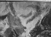
Classic low centered over the great lakes with a trailing cold front, dry slot behind the moisture trail in from the gulf due to the lack of dewpoint activity in the slot, drawing gulf moisture up and to the northeast along and ahead of the front. Absolutely coastal fog off the west coast, and of course, the impact of the mountains creating lift and drying out the airmass from the west and downslope channeling the focus of the frontal activity to the east. Bet if you looked at the TAFS, FA's and WIND charts for the regions, you could see this phenomenon by looking at those data
Can winter be far behind?
 
I hear ya! Cancelling a baseball playoff game for snow???? sheesh /// How about that domed stadium in the Mile High?
 
Back
Top