alaskaflyer
Final Approach
- Joined
- Feb 18, 2006
- Messages
- 7,544
- Location
- Smith Valley, Nevada
- Display Name
Display name:
Alaskaflyer
I recently downloaded my GPS tracks from my recent flights for use in Google Earth. Tonight I realized that the track log from my entire flight up from Kalispell, MT to Fairbanks was in there too. So I manufactured it into a single track for Google Earth, atttached below. If you have GE, and Firefox, it will be pretty easy to open. If you use IE and Google Earth, keep opening windows until you get to the .kml file, then double click, it will open GE automatically. The flight took place in two trips, the first in October then the rest of the way after Thanksgiving last year. Enjoy.
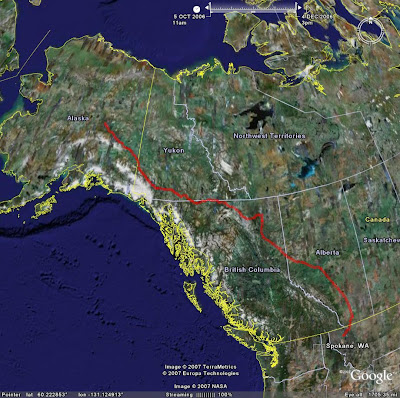
The track reflects altitude too, so if you tilt down and zoom in you will see my track hanging in the air.
Oh, and the track is pretty accurate. Look at my touchdown spot at the end of active log 8 That is a standard Canadian pattern by the way.
Hint if the entire track isn't showing you may have to spread the time slider in the window to redefine the time range to reflect the whole trip. Here's how.
The track reflects altitude too, so if you tilt down and zoom in you will see my track hanging in the air.
Oh, and the track is pretty accurate. Look at my touchdown spot at the end of active log 8
That is a standard Canadian pattern by the way.Hint if the entire track isn't showing you may have to spread the time slider in the window to redefine the time range to reflect the whole trip. Here's how.
Attachments
Last edited: