Tough weather

gismo

Touchdown! Greaser!
Joined
Feb 28, 2005
Messages
12,675
Location
Minneapolis
Display Name

Display name:
iGismo
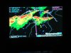
Yesterday I started on my way to Venice Florida (south of Tampa/Sarasota) with a planned overnight stop in Bowling Green KY (BWG), and the wx along the route wasn't very good. After I threaded my way through a big line of TRW in southern IL and northern KY a jucy storm blew into BWG when I was about 30 miles out. Given that it was night and the entire area was full of developing storms I elected to land at a nearby airport until the wx at BWG cleared. 20 minutes later we were back in the air for an uneventful short hop to BWG. Then this morning we got underway to complete the trip and had to penetrate three lines (actually did an end run around the first). This is the first trip among TRW for me since I added XM wx to the cockpit and it was a great help although I was surprised at how poorly the NEXRAD depiction of precip correlated with my onboard radar. There were several times when the NEXRAD indicated level 3 precip (RED) and the onboard display showed nothing or level 1 as well as times when the opposite was true. Even with that inaccuracy, the NEXRAD was very useful in planning my path so as to minimize the need to fly close to storms and I would have been far less comfortable making the trips without it. But given the discrepancies I'd sure hate to try this without onboard radar as the gaps were about the same size as the error in location.
 
Given that you were back in the air within 20 minutes would you have rather requested a hold somewhere clear of the line?
 
Lance, what altitude/altitude range were you flying for these legs?
 
I had been at 9000 or 11000 prior to arriving in the area, but by the time I'd gotten past the first line in the attached picture, I was down to 5000 in preparation for landing at BWG. I made it around the closest area of precip but by then the cell near the "160 NM" label had moved right on top of BWG. I could have gone into a hold, but as you can see there was serious wx all around and the whole area was rather unstable so I wasn't sure that I'd have room to hold without a cell popping too close to me. The delay we needed was close to half an hour (20 mins on the ground plus 10 enroute to BWG from the airport I dropped in on) so it was also less costly to land than to hold. Usually when a hold is needed to wait for an improvement in the wx there aren't a bunch of VFR airports in the vicinity.
 

Attachments

  • DSCF2367 (640 x 480).jpg
    DSCF2367 (640 x 480).jpg
    54.4 KB · Views: 33
Lance, that was what I was thinking WRT a hold. It's better to just land rather than hold in a large unstable air mass with cells popping up all quadrants.
Thanks fors your reply.
 
Thanks for that report. These are the types of reports I really get into.
 
Have a great trip Lance.

I've generally had the same thing occur as to intensity with the NEXRAD, much lower than what the display shows. Assuming 30 is yeller and 40 plus is red (reflexitivity); the NEXRAD pretty consistantly shows more intense than my on-board radar.

Dave
 
Dave Siciliano said:
Have a great trip Lance.

I've generally had the same thing occur as to intensity with the NEXRAD, much lower than what the display shows. Assuming 30 is yeller and 40 plus is red (reflexitivity); the NEXRAD pretty consistantly shows more intense than my on-board radar.

Dave

I assume you realize that due to STC (sensitivity time correction, not Supplemental Type Cert) limitations, most GA Radars show precip beyond about 30 nm at a lower intensity than reality. In this case the NEXRAD was pretty accurate around BWG, but further south on the next day I saw some big errors. The innacurracy of the NEXRAD images seemed to be more location than rain rate.
 
lancefisher said:
I assume you realize that due to STC (sensitivity time correction, not Supplemental Type Cert) limitations, most GA Radars show precip beyond about 30 nm at a lower intensity than reality. In this case the NEXRAD was pretty accurate around BWG, but further south on the next day I saw some big errors. The innacurracy of the NEXRAD images seemed to be more location than rain rate.

Lance, my assessment is that there is some error, most apparent where rain is building or dissipating rapidly. In those cases, you really have to use a mix of information, though with some practice in interpertation and study of the storm movements, you can get fairly decent results from Nexrad. I don't bet the store on it, though... I use it in conjunction with a stormscope (no room for radar on the plane).

One source of potential error is the way that the NEXRAD images are stitched together between sites. I've spent a bit of time down here studying the returns from 2-3 sites during storms. They do not correlate 100% when you isolate each site separately (you can do that using the NWS sites... WxWorx/XM only provides the composite view). For example, I'll see a difference between the results from Del Rio vs New Braunfels sites when looking at a storm cell in the Uvalde area. I assume the algorithm that creates the composite adds the reflections in a way that accounts for the errors.

It would be interesting to delve more into the details on how this is done.
 
wsuffa said:
I assume the algorithm that creates the composite adds the reflections in a way that accounts for the errors.
It would be interesting to delve more into the details on how this is done.

One factor is that NEXRAD coverage doesn't extend to the ground due to the Earth's curvature and the lowest angle that the antenna points. The further you are away from the site the higher the bottom of the scan. I'd expect this to result in a less intense echo though and most of what I've seen errored on the high side of precip. But much of the error is likely due to the latency between the data collection (radar sweep) and the display in your cockpit.
 
TMetzinger said:
And of course the NEXRAD is delayed....

Which is what I meant by:

But much of the error is likely due to the latency between the data collection (radar sweep) and the display in your cockpit.

:p
 
lancefisher said:
Which is what I meant by:

But much of the error is likely due to the latency between the data collection (radar sweep) and the display in your cockpit.

:p

Yeaaaaaaaaahhhhbbbuuuutttt. It's nice to have that NEXRAD when your primary radar goes out. That happened twice to me. Wish the Lears I fly now had that as a back up. We are looking into EFB solutions that have that feature for this simple reason.
 
Brent Bradford said:
Yeaaaaaaaaahhhhbbbuuuutttt. It's nice to have that NEXRAD when your primary radar goes out. That happened twice to me. Wish the Lears I fly now had that as a back up. We are looking into EFB solutions that have that feature for this simple reason.

Absolutely (I now have both, hence the comparision). My point was that you need to give TRW a wider berth with XM-NEXAD than with onboard radar and that may well mean you can't cross a line of weather as safely as you could with onboard radar if all you have is NEXRAD. That said NEXRAD allows for a much better picture of what's ahead including a fairly good idea of what will be there when you arrive.
 
check out freightdogtales.blogspot.com i think thats the right URL. he has some pretty good info on how to get the most out of your on board radar. plus tons of other great stories
 
jdwatson said:
XM-NEXRAD has to beat Mark-IV Eyeball. :)
Only if you're in cloud. If you can see ahead, nothing beats the ol' eyeballs for short range storm avoidance.
 
Back
Top