The Go/No go and freezing rain?

dell30rb

Final Approach
Joined
May 18, 2011
Messages
7,147
Location
Raleigh NC
Display Name

Display name:
Ren
Here's a new one for me.

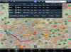
Planning a trip from Raleigh, NC to Nashville, TN this afternoon. Leaving so I'll have plenty of time to get there before dark. Weather on the other side of the mountains was not looking so good, thought I was going to have to scrap the trip because I'd have difficulty getting down under the clouds past the mountains.

But wait! The mountain range is not all that large. I can go around them, and it only adds 35nm to the trip! Last night this was looking good, no ceilings under 4500 forecast anywhere along the route and only patchy rain showers on the last 50nm of my trip.

Wake up this morning to find the weather still looking good, except the last 50nm is worse. the TAF for BNA (20mi north of my destination) is showing light rain from 2-5pm still VFR ceilings and visibility. My concern here is freezing rain at altitude. The winds aloft forecast has the temp at 4C on the ground, -2C at 3000 feet, and -1C at 6000 feet. So there is probably freezing rain in there somewhere correct?

There is an airmet for icing from 9000 down to 2000 feet. CLP icing forecast shows a trace of ice is forecast at 3000 feet for about the last 10 mi of the trip.

Airplane is a C152 with xm wx and IFR stuff incl a new OAT gauge. I was thinking i'd just stay under the freezing air and out of any rain showers, but now with "light rain" instead of showers in the forecast it looks like I may not be able to avoid all moisture, or freezing temps.

Does not look like i'm going anywhere! Waiting for the taf's to come out to see if tomorrow is a possibility.
 

Attachments

  • foreflight.png
    foreflight.png
    1.3 MB · Views: 39
I'm sure others will chime in, but I'm a NO.
 
Last edited:
Yeah based on present forecasts I have decided not to go this weekend at all. Even if I could get up there tomorrow morning, it is going to be rough coming home sunday after this front passes. Not a pleasant trip, rescheduling!

I posted this mostly cause I was interested in hearing some input on the freezing rain situation, and if others think I have analyzed the situation correctly based on the info. I am close to obtaining my instrument rating so understanding icing is of interest to me now :)
 
I was going to post something untill the "smart folks" requirement showed up:)
 
I was going to post something untill the "smart folks" requirement showed up:)

Wasn't meant to be smart a$$ or anything. I just realize that there are other on the board much smarter than I am on this stuff. :wink2:
 
TSA, just making a joke off of your joke. I had nothing to add. But your requirements did eliminate me:rofl:
 
I think you're making a good call to stay home. All that's needed for ice is visible moisture and cold temps, and rain at the surface may be SLD higher up even though you're not in the cloud bases yet.
 
I haven't looked at the forecasts but freezing rain in the forecast is a no-go for me in a de-iced Baron. If you can determine that it's possible to fly below the clouds and avoid the rain visually through the area where freezing rain is predicted then you might consider going as long as you're willing to land short of your destination should it become impossible to stay visual and avoid the rain. Freezing rain can turn almost any airplane, especially one with nothing but a heated pitot for deice into something with all the aerodynamics of a bowling ball in just a few minutes.
 
No forecast for freezing rain, just an interpretation by me that there may be some! I'd land short and get a car but I can just go another weekend
 
Id go, you have no idea if those conditions will even create ice or freezing rain. Just make sure you have an out, which it sounds like you do. VFR conditions exist, and if IFR altitude restrictions don't really exist (like high MEA) then even if you do encounter some ice you can get out of it.
 
I am no expert (low time pilot, here), and I throw this out there for comment and correction from those more knowledgeable:

When I read the original post, I thought to myself that the data didn't show a temperature inversion, so not likely to have freezing rain. Maybe icing if in the clouds, and maybe precipitation that could be in the form of snow that melts when it falls into the lower warmer air. But no moisture dropping into levels of freezing, resulting in super-cooled water ready to freeze on contact. Am I close?

Scottd, wow. Great information. Seems you got to the same place I did, but did I get there for the wrong reasons? Thanks.
 
I pulled up this sounding and it does look like there is only one freezing level at about 2,000 feet.

20120210-mnwibeiga7gssqt9xybpwwh247.png
 
PPC - low time, non-expert IFR pilot here too, and I had exactly the same thoughts. Thanks, Scott, for the useful lesson!
 
Thinking to what I'm learning un class, snow usually indicates liitle icing in the lowest layer of clouds but is no guarantee against it in higher layers. Is that right?

Sent from my ADR6300 using Tapatalk
 
Thanks, Scott. What I'm really taking away from this is that without looking at the Skew-Ts (or the CIP/FIP products), you can be surprised.

And that the "standard" products (and the rules of thumb that go with them) are inadequate.
 
Thanks, Scott. What I'm really taking away from this is that without looking at the Skew-Ts (or the CIP/FIP products), you can be surprised.

And that the "standard" products (and the rules of thumb that go with them) are inadequate.
No matter what the forecasts say, you need to have at least one, preferably two escape routes to fall back on should the ice be worse than the predictions. Without deice (and even with it in a situation like that) reversing course is the best option but that option may only exist for a very short time.
 
I know the taf's are just that, terminal forecasts. However looking at several along the route can help paint the big picture. Generally I look at area forecasts first, and then a couple of taf's along the way to see if anything deviates substantially from the area forecasts.

In this case the ceilings turned out to be pretty low and the clouds were producing snow. Staying home was a good call.

I did get CIP and Fip mixed up.

Thanks for the replies!
 
Oh and the winds aloft forecast I was looking at with temps is whatever fore flight puts out. They do list a temp for 3000 feet.. Not sure where they get that data
 
Scott, thanks for the info. I have a question. There is a service called Weather Tap that I use for my weather. One of their products is "forcast icing potential". Are you familiar with this and if so what do you think about it? I am not sure how they arrive at it. I would appreciate any oppinion you have on it. I can send you my pass word by PM if you are not familiar with it and would like to look at it. Again thanks for your information!
Ronnie

I think that is the FIP

http://aviationweather.gov/adds/icing/description/page_no/3
 
Scott, I looked at your e-tip and that is the product that Weather Tap is useing. Like stated in your e-tip they are now calibrated probability both the forcast and current. My question is how good are they? I fly a turbo prop and I use these quite a bit. Just looking for a qualified oppinion.
 
I've flown through freezing rain. Not recommended. Full power on the Arrow and I could barely hold altitude. And just try landing when your windscreen looks like one of them frosted bathroom windows.
 
Scott, I don't know any active instructors that would be of much use since the 172's they fly are not flown in a lot of ice. I do appreciate the info.
 
Oh and the winds aloft forecast I was looking at with temps is whatever fore flight puts out. They do list a temp for 3000 feet.. Not sure where they get that data

Anyone have a clue on this?
 
Back
Top