Student Question re Flight Plan with Multiple Altitudes

eetrojan

Pattern Altitude
Joined
Jan 19, 2012
Messages
1,531
Location
Orange County, CA
Display Name

Display name:
eetrojan
Hi all.

I’m a student. Nearly done… :)

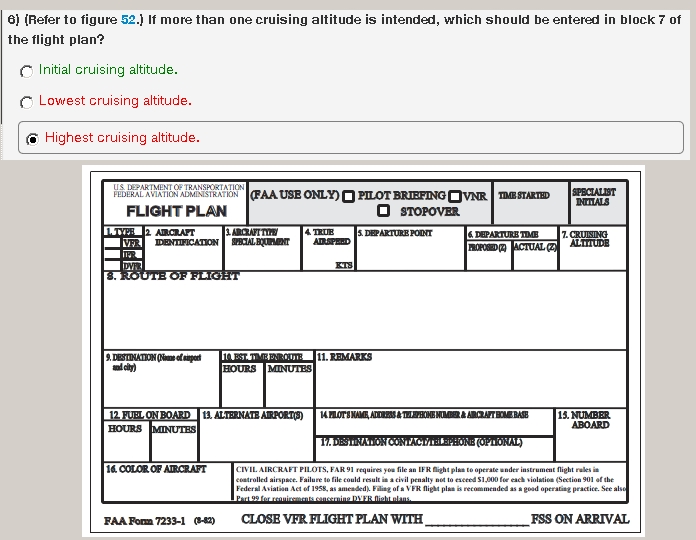
When preparing and filing a VFR flight plan with multiple altitudes between airports (e.g. 3,000 ft MSL for first leg, followed by 8,500 ft. MSL for second leg to destination), my school teaches me to file my box 7 “cruising altitude” with the highest VFR altitude (e.g. 8,500 in my example). The reason given is that should I need to put her down along the way, the higher altitude will correctly causes searchers to expand their search zone based on my glide range. That makes good sense to me, but I want to dig around a bit more.

My memory is that IFR flight plans are filed with the “initial” cruising altitude rather than the highest altitude. True?

I’m aware of 91.153 re the information required for a “VFR flight plan,” but it doesn’t address multiple altitudes and simply identifies “cruising altitude” as part of the required info. I’m also aware of AIM 5-1-1(f) which references “Flight altitude(s)” in the plural. However the official FAA flight plan form seeks only one altitude and, in my limited experience in phone filing a plan with WX-BRIEF, they seem to want only one altitude.

I was hoping to find more info on this topic. Is there a FAR, AIM, FAA, or some other official or semi-official sources that I can read on how to handle multiple altitudes in one flight?

Thanks!
 
Why is 3000' your initial altitude? (I'm suspecting you'll be under a shelf of overlying airspace) Why would you consider this as your "cruise altitude" when you plan on climbing further? If my suspicion is correct, 8500' is your "cruise altitude" but you have an initial "restricted altitude" leg you have to get through first.
 
Why is 3000' your initial altitude? (I'm suspecting you'll be under a shelf of overlying airspace) Why would you consider this as your "cruise altitude" when you plan on climbing further? If my suspicion is correct, 8500' is your "cruise altitude" but you have an initial "restricted altitude" leg you have to get through first.

Exactly right. On the first leg, I plan to climb to and then cruise at 3,000 feet to be over some deltas and under a bravo shelf, and on the second leg, I plan to climb and then cruise at 8,500 feet to get above a charlie and ultimately get through a mountain pass that crests around 4,600 feet and has surrounding peaks at around 9,000. The leg at 3,000 ft is about 45 nm long, and the leg at 8,500 ft is about 80 nm long.

I could rationalize "cruise altitude" as my initial altitude of 3,000 (what I remember learning for my written test some time ago), or my highest altitude of 8,500, or perhaps as the altitude of my longest leg (but that seems unworkable from flight to flight).

Just looking for some reading material...
 
Last edited:
Exactly right. On the first leg, I plan to climb to and then cruise at 3,000 feet to be over some deltas and under a bravo shelf, and on the second leg, I plan to climb and then cruise at 8,500 feet to get above a charlie and ultimately get through a mountain pass that crests around 4,600 feet and has surrounding peaks at around 9,000. The leg at 3,000 ft is about 45 nm long, and the leg at 8,500 ft is about 80 nm long.

I could rationalize "cruise altitude" as my initial altitude of 3,000 (what I remember learning for my written test some time ago), or my highest altitude of 8,500, or perhaps as the altitude of my longest leg (but that seems unworkable from flight to flight).

Just looking for some reading material...

Your cruising altitude is the one you select for reasons of your own. The other altitudes are restricted altitudes you transition through.
 
File the altitude you are actually planning on cruising at after you get through the restrictive airspace. That way the controllers know what your final alt is.
 
File the altitude you are actually planning on cruising at after you get through the restrictive airspace. That way the controllers know what your final alt is.

On a VFR flight plan? No controllers are going to see it. But yes, I agree that that's the altitude you should file for SAR purposes.
 
The AIM addresses this issue.
7. Block 7. Enter the requested en route altitude or flight level.
NOTE-
Enter only the initial requested altitude in this block. When more than one IFR altitude or flight level is desired along the route of flight, it is best to make a subsequent request direct to the controller.
Of course, for VFR flight plans, it doesn't really matter what you put in this block, since if you don't show up at your destination, they won't be searching for you anywhere but on the ground below your proposed route of flight.
 
The AIM addresses this issue.
Of course, for VFR flight plans, it doesn't really matter what you put in this block, since if you don't show up at your destination, they won't be searching for you anywhere but on the ground below your proposed route of flight.

Ron Levy said:
7. Block 7. Enter the requested en route altitude or flight level.
NOTE-
Enter only the initial requested altitude in this block. When more than one IFR altitude or flight level is desired along the route of flight, it is best to make a subsequent request direct to the controller.

Thanks Ron. That helps. The corresponding AIM section re VFR Flight Plans (AIM 5-1-4), simply says "Enter the appropriate VFR altitude (to assist the briefer in providing weather and wind information).

I think my hesitation to use my final, highest, VFR cruising altitude of 8500, and want to go with my initial altitude of 3000, is because I memorized "Initial Cruising Altitude " as THE correct answer when I prepared for the written test based on this sample question:

Initial_Cruising_Altitude.jpg
 
I have heard that the cruising altitude on a VFR flight plan gives searchers an idea of how far you might have glided from your filed route in case of an engine failure. How useful that is in practice, I don't know.
 
... the higher altitude will correctly causes searchers to expand their search zone based on my glide range ...
If you want to get found, use flight following and stay high enough to have radar service if at all possible. Forget the flight school's nonsense.

Do the math: A 100nm flight at 8,500 means you could theoretically glide into an area of something like the state of Delaware. Not too helpful in planning a search. As Ron said, the search will be below your proposed route of flight. So if you're gonna glide, maintain your heading until you get to the point of picking a landing area. But being on radar is better. Calling the controller and and advising him/her of the situation is better yet.
 
If you want to get found, carry a 406 G/PLB
I do, but for it to be effective you have to be able to activate it after you land. So I'd still argue that being on radar and talking to ATC should be first priority.
 
If you want to get found, carry a 406 G/PLB
Or just start hollering on 121.5 with your location and intentions. Lots of people will be listening, including many with CVR's so the information is retrievable even if they don't have a pencil handy.
 
I do, but for it to be effective you have to be able to activate it after you land. So I'd still argue that being on radar and talking to ATC should be first priority.

No, you can activate it on the way down, no worries. I like being on radar and talking too, not long ago that happened to a guy and they sent SAR way in the wrong direction.
 
Or be sure you have your cell phone with you. They will find you.
In Maryland, maybe. There are many areas of the US where cell coverage at ground level is spotty, poor or zero. I have been on two major searches where we had in-air cell phone data but it was incomplete and in the end no help.

That said, I do carry my phone and leave it on (don't tell the FCC) but it is radar and ATC that I'm betting on.

Leaving it on in flight unless you have it plugged in may not be the best option either since it runs the batteries to hell quickly.
 
Use the system,flight following and radar. That's what our taxes help support. Always nice to have someone to talk to ,on a long cross country.
 
Use the system,flight following and radar. That's what our taxes help support. Always nice to have someone to talk to ,on a long cross country.

I'd rather not give them a justification for instituting per-use user fees, so I just monitor the frequency, and if it's a long flight, I also file a flight plan.
 
I'd rather not give them a justification for instituting per-use user fees, so I just monitor the frequency, and if it's a long flight, I also file a flight plan.
:confused::crazy: Talking to ATC on FF will not be the determinant on whether we get user fees or not. ATC would rather be talking to you than not, especially where you are.
 
Thanks Ron. That helps. The corresponding AIM section re VFR Flight Plans (AIM 5-1-4), simply says "Enter the appropriate VFR altitude (to assist the briefer in providing weather and wind information).

I think my hesitation to use my final, highest, VFR cruising altitude of 8500, and want to go with my initial altitude of 3000, is because I memorized "Initial Cruising Altitude " as THE correct answer when I prepared for the written test based on this sample question:

Initial_Cruising_Altitude.jpg

Wouldn't be the first time the test questions didn't match the published information. ;)
 
:confused::crazy: Talking to ATC on FF will not be the determinant on whether we get user fees or not. ATC would rather be talking to you than not, especially where you are.

Agreed. At least they have an idea of what you're doing.
 
Leaving it on in flight unless you have it plugged in may not be the best option either since it runs the batteries to hell quickly.
I haven't had that problem but obviously YMMV and flight lengths vary.

The deal about leaving it on in flight is that the phone "checks in" with cell towers as it passes. This information can be obtained for SAR purposes and can help identify an airplane that is squawking 1200. If the time stamp on a check-in matches the time stamp on a VFR radar track with only one VFR airplane near that cell tower, then that track is effectively tagged with the missing airplane's tail number. This can then obviously be a big help in designing a search.
 
Agreed. At least they have an idea of what you're doing.

And can contact you quickly if something is going south. Once I was cruising north heading from Long Beach to SF when the controller came on with a very tense and shrill voice, "04Y IMMEDIATE DESCENT" I was shoving before ''...scent" came out as a King Air descended right through my flight path at rivet counting range.:eek:
 
Back
Top