SRR - Ruidoso NM

Pjsmith

Line Up and Wait
Joined
Oct 25, 2005
Messages
513
Location
Cary, Illinois
Display Name

Display name:
pjsmith
I'm toying with the idea of 'borrowing' my brother's house in Ruidoso over the holidays and flying out there from Chicago. I'm a flatlander and all of my mountain and near mountain experience is in/around the parts of the appalachians where peaks are no more than around 5k.

I've been reading about mountain flying and have taken the online course, as well as reading tons of pilot stories...I know, not as good as thorough training in the mountains...but again, I'm a flatlander.

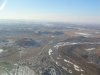
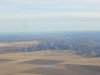
My question is this: after "flying" into SRR in flight sim and using topozone and google earth, it seems like this part of NM is actually east of the most mountainous of the mountains, and that elevations seem to be similar to what I am accustomed to out East.

Is my read of the landscape correct, or are my tools incomplete? Any reports and tips from pilots who have flown/do fly out of there would be really appreciated.

Patrick
 
Sort of.

KSRR is strange, in that it is located behind and between "mountains" (I quote because they're not very large).

When its windy, you'll get thrown around a bit. ITs really pretty there though...and a great atmosphere to the FBO too.
 
Go for it! You can get there without traversing any mountains.
There is the El Capitan range to the north, and Sierra Blanca peak about 10mi west. S.B. is associated with high ground that extends south and east. Approaching from the east, it won't be like you are going down narrow canyons and over ridges, far from it!
"elevations seem to be similar to what I am accustomed to out East." You will fly across gradually rising terrain in the last 1/4 of the trip, and crossing into NM the elevations are 4000-4500' depending on where you enter. Then passing the Pecos R. abeam Roswell the terrain climbs into your destination which is at 6811'asl. Usually in winter you will be fighting pretty good headwinds, plus you are going uphill so watch your fuel.
You didn't say what you are flying but Im certain its not the a/c depicted in your avatar. Assuming a light single, and a pilot of average experience, I would avoid anything but decent vfr in the winter for your first mountain experience here. Also watch those winds aloft, if it is 20kts at the peak of SB as it often can be in winter, you are in for a rough ride which gets worse and more dangerous as the wind increases.
Mornings are usually best. Avoid full loads. Lean properly on takeoff. Set a no-go point on the runway for your departure. Don't expect it to climb out sprightly on t-o, you may have 0 climb rate for a half a mile, don't force it. Use normal published indicated airspeeds for approach, landing, takeoff, climb; don't 'adjust' for the D.A. Call ahead for runway conditions, I have been surprised by black ice thataway before. And numerous other things you might have read about. Take cold wx clothing. Take winter survival kit.
Oh, do you have ground transport at srr? My main dislike of that airport is the distance from town and lack of efficient/inexpensive vehicles.
Have fun!
ibw55f.jpg
 
Last edited:
Nick, Dave, thanks for the information. I will be flying a Cherokee 180, VFR, much of the trip will be dependent on the weather. I have two stops planned en route, either of which can be a day or two layover or turn around.

Dave, I especially appreciate the advice on anemic performance!
 
Nick, Dave, thanks for the information. I will be flying a Cherokee 180, VFR, much of the trip will be dependent on the weather. I have two stops planned en route, either of which can be a day or two layover or turn around.

Dave, I especially appreciate the advice on anemic performance!

I've taken a Cherokee 180 in and out of there a few times. No worries about anemic performance with 180 horses behind the prop.
 
It's been decades since I've been there (raised in Tularosa, a few miles west on Hwy. 54), but if you're not comfortable with winds around Old Baldy (Sierra Blanca), head on down into the Tularosa Basin to Alamogordo (KALM). Lots of room to get around, and really flat. Of course, I've not ever flown there; just got a ride in an early C310 about 40+ years ago:rolleyes:, so I might be way out in left field.

Jim
 
If you take a 180 Cherokee into Ruidoso, don't load it with more than two people and a couple of suitcases until you have a lot more mountain flying experience.
 
If you take a 180 Cherokee into Ruidoso, don't load it with more than two people and a couple of suitcases until you have a lot more mountain flying experience.

As of right now, the trip is a go for this weekend (though I might be turning around in missouri, or kansas, or Oklahoma, or ....)

I'm confused, a little. Some of the comments indicate that this is not 'mountain' flying, and this post suggests that it is. Certainly I'll be in proximity to ranges such as Capitan and watching for their effects, particularly on landing. Would appreciate some feedback on that point.

In any case, and unfortunately, I have planned on a third person and a third suitcase. I'm a big guy, my pax are definitely not, but short of not going altogether, I'm taking two, at least as far as I go.


Have fun, PJ! I look forward to reading the trip report, and hopefully seeing some pictures!

What kind of plane are you flying? I think somebody already asked that, and I didn't see the answer...
 
Some of the comments indicate that this is not 'mountain' flying, and this post suggests that it is. .

You will be under the influence of higher elevations and the associated effects on performance but you probably won't be doing any canyon turns or landing on glaciers!

TW I see Cher180 noted.
 
You will be under the influence of higher elevations and the associated effects on performance but you probably won't be doing any canyon turns or landing on glaciers!

TW I see Cher180 noted.


Ah, yes indeed; post #5. Thx. Off to get my eyes checked... ;)
 
I'm confused, a little. Some of the comments indicate that this is not 'mountain' flying, and this post suggests that it is. Certainly I'll be in proximity to ranges such as Capitan and watching for their effects, particularly on landing. Would appreciate some feedback on that point.

The airport is 68xx' MSL. Although it is not "mountain" flying, it is definitely in the range of "density altitude" flying. On landing you will feel like you are going much faster (ground speed) than at sea level. On takeoff, it'll fell like you are taking off with the throttle significantly pulled back, and your takeoff run will feel like forever. Good advice from Ron.

Phil
 
Just got a digital video camera for my birthday, so I'll take some photos and maybe a passenger will get some video of my landings (only if they're good....funny how bad shots get accidentally deleted).

No, I'm not flying up any canyons, and I hope to be ok Vis a Vis winds, but still am hoping to get a few more pearls of advice on that point (Nick has some great stuff in his write-up).

Thanks Phil. Unfortunately, I don't have the option of only flying two up. But I do have the perf. charts down pat and have arranged the trip to have less than half tanks when we depart to tilt things in my favor.
 
Last edited:
In any case, and unfortunately, I have planned on a third person and a third suitcase. I'm a big guy, my pax are definitely not, but short of not going altogether, I'm taking two, at least as far as I go.
If you're not going to be at least 200 lb below max gross on departure from SRR (and you might want to use "tabs" fuel and make your first leg a shorter one to help achieve that), you may be very surprised by your plane's lack of performance. Having 8000 feet of runway is nice, but 8000 feet of runway at 7000 feet elevation ain't nothin' like 8000 feet of runway at sea level, or even 3000 feet elevation. The fact that it's rather cooler this time of year helps, but if you load up to max gross, your takeoff/climb performance is going to leave a lot to be desired. And if the wind isn't blowing right down 12/30, don't even think about using that shorter runway -- 1500 feet more runway can be make-or-break.
 
Well, we're back and in one piece! None of the few in-flight pictures came out well, so no photographic expose, unfortunately.

I gained some great experiential knowledge on this trip, among it:

- If you flight plan out 8.5 hours of flying time, make sure your spouse/S.O. understands this does not factor unforseen winds, or the three stops you have to make. Expectation management is the key here.

- I probably wouldn't fly into SRR at night if I had the choice (I didn't...against the headwinds, I lost my race with the sun). El Capitain and Sierra Blanca both produce some interesting turbulence, even with a 4 mile berth. I don't know if it is the same in the day time, but in the dark, with the knowledge that there are mountains out there, the winds add plenty of pucker.

- I learned that this board is invaluable, when my ammeter registered 0 and the digital vm showed 12.1....I would have landed in less than ideal wind conditions on the way back if I hadn't once read here about cycling the master to resolve this situation.

- I learned that you can't always consider 300 FPM to be an acceptable climb rate, even if the bird will do no better.

On the plus side,

- I learned that SRR is about the most professional setup I've encountered; When I radioed in 10 miles out, they offered to call a cab for me. When I landed, they were waiting at the end of the taxiway to lead me to the tie down area. They tied (chained) me down and took my pax in a heated truck over to the hangar, then came back and helped me load in the luggage and get the plane otherwise situated. Great people all around.

- I learned that I can, in fact, make a 1,000 mile trip in my Cherokee, though I don't know if I will ever do it again in one day.

- I learned that "against the wind both ways" isn't necessarily a cliche.

For me, it was a good experience, though a lot of flying.

My S.O. tired of the cherokee seats pretty quick, and the back seat passenger was freezing even as we were roasting up front (It's an older cherokee thing). The only upside is that, on return, the announcement was made that "we need a plane a little bigger and a little faster". MISSION ACCOMPLISHED! now I just need to find a way to finance that dream........
 
Congrats on your successful trip! Now about those photos...:)

Seriously, at your leisure, perhaps you could write up your landing and T/O experiences at SRR, including WX, if you remember the details. Might be useful to us later...

Glad to see you made it back in one piece! Now just who made that "announcement"?

Not much to tell, really. I was approaching SRR from the Northeast (see the chart that was posted above), which leads you past the tip of "El Capitan". I had planned on diverting a bit south and coming in almost directly from the east, but the 4 mile buffer I gave myself from El Capitan was not enough, we still had plenty of turbulence from that hill (I assume). Once I was, say, on about the 95 degree point to the field, things smoothed out quite a bit for me. The airfield elevation is 6800 feet and the mountains are 10,000 feet or a bit more, and really stand out. Winds, at the time, were from 280 at 7 knots. Therefore I landed on 240, the long, wide, runway. Conveniently, this was the direction I was mostly already heading.

No traffic that evening meant I was going to enter on a base leg, and this contributed to me being a little high coming into the pattern (some of this was also being shy about the terrain, I have to admit). I had been landing all day with a little extra speed due to two pax, bags and wind, and I didn't vary much from that plan, though I will say the plane settled out a lot quicker at that altitude than at previous stops. Hadn't thought about sink rate much at higher altitudes, but I guess it makes sense that you fall faster through thinner air. Next time I think I'll do it with less flap.

SRR has a nice, wide, long runway, so you have a lot of opportunity to save a crummy landing.

Taking off.... there was no wind so I departed on rw 6. My 180 did a fair job of accelerating to rotation (up from normal rotation) in the first half of the runway and I let her climb into ground effect where I stayed for another couple of hundred feet to get some speed. Even with that, the climb rate was sort of pathetic. Also, the terrain off the end of 06 rises a few hundred feet. Not right away, but it does, so as you're climbing it seems like you're not going anywhere. I'd say it was two or three minutes of that feeling.

edit: below are the few halfway decent snaps. K26 is the FBO at Carrolton muni airport...we intended to stop at the new MO8, which got great fuel price reviews on airnav, but the field hadn't been snow plowed from the snow the day before. So we lucked out with a quick diversion about 10 miles south, where we found this gem. Fuel was $3.60 self serve, the FBO building was unlocked, had heat on, a filtered drinking fountain and a bathroom for the pax, plus maps, charts, etc. Definitely a nice touch. The only land pic is from the front window of the house.. every morning deer came through the block for breakfast in each of the front yards. Locals find it annoying. I think it's kinda cool.
 

Attachments

  • FBO@k26carrolton.jpg
    FBO@k26carrolton.jpg
    500.8 KB · Views: 4
  • texasbuttes.jpg
    texasbuttes.jpg
    568.5 KB · Views: 6
  • Amarillocanyon.jpg
    Amarillocanyon.jpg
    448.9 KB · Views: 4
  • losingtherace.jpg
    losingtherace.jpg
    375.2 KB · Views: 5
  • breakfast.jpg
    breakfast.jpg
    583.2 KB · Views: 6
Last edited:
Back
Top