Skew-T: Am I interpreting this correctly

dell30rb

Final Approach
Joined
May 18, 2011
Messages
7,147
Location
Raleigh NC
Display Name

Display name:
Ren
Unfortunately a LabCorp PC12 crashed after departing burlington airport this morning, about 7 miles from the runway. Since it was a cold morning with low clouds and some precip, I decided to investigate and see if ice was a factor.

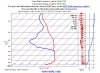
I pulled up the Skew-T for the approximate time of departure at a nearby airport.

What I am getting from this, is a temperature inversion up to about 5000 feet, stable air above that. The freezing level is around 12,000 feet and tops 13,500. Could have been a fair amount of ice in the tops.

Thoughts? Can anything else relevant to flight conditions be drawn from this?
 

Attachments

  • skewt.jpg
    skewt.jpg
    97.5 KB · Views: 121
I'm not an expert either, but I read the Skew-T the same way as you do: strong inversion to about 5000, freezing level somewhere around 12000. Tops are harder to pin down, but they were probably somewhere around 13,500 based on the divergence of the temp and the dp curves. Could have been a much higher layer above composed of glaciated clouds (if I'm reading the way the temp and dp curves parallel each other correctly).

I have no idea whether ice could have been a factor. It seems like the whole column would have been above freezing up to 12,000. Do you have metars from that time? Which Burlington was this? Vermont? The metar from KBTV at that time shows a lot colder surface temps, and generally doesn't seem to match.
 
I think you've read the skewT correctly. I have not found the historical METARs from Burlington for this morning. There has been snow/rain in New England all day. My daughter reported about 2inches of fluffy snow in Quincy Mass (BOS) this morning and then a change to rain. Granted she is some distance from the mountains of upstate VT.

I would suspect freezing rain down low, and possibly the aircraft was not adequately deiced before departure. Could have been a mechanical issue or frozen pitot/static system on departure.
 
I would suspect freezing rain down low, and possibly the aircraft was not adequately deiced before departure.
I'm not sure why you would say that based on the diagram since it appears that everything below about 12,000' was above freezing.
 
Historical METARS from KBTV:

http://aviationweather.gov/adds/met...rs=on&hoursStr=past+24+hours&submitmet=Submit

KBTV 161554Z 17008KT 1 1/2SM -SN BR FEW010 BKN030 OVC049 M01/M03 A2998 RMK AO2 PRESFR SLP158 VIS 1V2 SHSN OBSCG MTNS NE-SE P0001 T10111033
KBTV 161536Z 17006KT 2 1/2SM -SN BKN050 OVC060 M01/M04 A3000 RMK AO2 VIS 2V4 SHSN OBSCG MTNS NE-SE P0001
KBTV 161524Z 18006KT 3SM -SN SCT055 OVC070 M01/M04 A3001 RMK AO2 SNSH OBSCG MTNS NE-SE P0000
KBTV 161454Z 18006KT 8SM -SN OVC080 M01/M04 A3002 RMK AO2 SLP169 INTMT SHSN P0000 60000 T10111044 58020
KBTV 161354Z 19007KT 9SM OVC090 M01/M06 A3004 RMK AO2 SNB23E54 SLP179 P0000 T10111056
KBTV 161254Z 15003KT 10SM BKN055 OVC090 M01/M07 A3007 RMK AO2 SLP186 T10111067
KBTV 161154Z 00000KT 10SM FEW055 OVC090 M01/M07 A3008 RMK AO2 SLP189 T10111067 11011 21022 56022
KBTV 161054Z 00000KT 10SM OVC095 M02/M07 A3009 RMK AO2 SLP194 T10171072
KBTV 160954Z 00000KT 10SM BKN095 OVC120 M02/M07 A3011 RMK AO2 SLP200 T10171072

If the crash occurred around 10Z, it seems the ceilings were above 5000 and remained high for at least another 4 hours.

Based on the OP's description of conditions at the time as well as the Skew-T, I question whether it was KBTV. An inversion like that would have melted any snow falling through it. Also the saturated lower levels in the Skew-T don't match the 5C T-DP spread in the 10Z METAR.
 
KBTV has been below freezing all day long. Light snow , low vis and low clouds dominated the day.

Nevermind, upon further investigation, it was Burlington, NC.

My synopsis was from Vermont area. Pay no attention to me, these are not the droids you are looking for.
 
Last edited:
Conditions at: KGSO (GREENSBORO , NC, US) observed 1033*UTC*16 January 2013
Temperature: 4.0°C (39°F)
Dewpoint: 4.0°C (39°F) [RH*=*100%]
Pressure (altimeter): 30.01*inches*Hg (1016.3*mb)
Winds: from the ENE (60*degrees) at 8*MPH (7*knots; 3.6*m/s)
Visibility: 10 or more miles (16+ km)
Ceiling: 500 feet AGL
Clouds: broken clouds at 500 feet AGL
overcast cloud deck at 1500 feet AGL
Weather: no significant weather observed at this time
 
Yep, Burlington, NC. Sorry for being so vague.

Strange accident.
 
Maybe he just got spatially disoriented or accidentally kicked off the autopilot and spun it in . . .
 
Maybe he just got spatially disoriented or accidentally kicked off the autopilot and spun it in . . .

I'm thinking not, hopefully. I understand that the plane was one of Lab Corp's, a PC-12. When I was flying there for my commercial, they were flying Aztecs I believe. I don't know their business or pilots but KBUY seems to be one of their home bases. They do a lot of flying at all times and in all conditions. That suggests some proficiency.

Not that is saves anyone's life, but I'm guessing it will be something other than a non-professional getting in over his head. We'll see.

I was watching the weather around there all week for some potential proficiency work. That morning was foggy, low and wet with cloud layers everywhere. Possible ice was north of there. Interestingly, it was the kind of undulating occluded front that can be very hard to forecast day to day. It's been amazing how changeable actual conditions have been relative to each forecast cycle.
 
@ScottD --

This thread got me curious enough to find your "intro" video on the Skew-T diagrams on YouTube. Wanted to give you some "Well executed" praise for the quality of the information and presentation.
 
Okay, more questions.

How accurate is the SkewT at the surface?
TAF is showing mist and fog from 10PM

The skewT shows a 3.4C dewpoint spread on the ground from 9-10PM and a 2.6C spread from 10-11PM.

I'm planning to be on the ground at 9PM. I have a good alternate in case I get fogged out of my home base. I'll be in the nearby area practicing approaches. And checking the AWOS for the temp/dewpoint spread, and probably heading back if the spread reaches 3 degrees before 9pm
 
Last edited:
FSI=4Ts-2(T850+TDs)+W850 * FSI Likelihood of Radiation Fog
Ts is the surface temperature in oC. * >55 Low
T850 is the 850mb temperature in oC. * 31-55 Moderate
TDs is the surface dew-point in oC. * <31 High
W850 is the 850mb wind speed in knots. * * *

Fog Stability Index= 4 X 16.6-2(11.3+12.3)+27
FSI= 66.4-47.2+27
FSI= 46.2

At 9 PM= Moderate @ KGSO.
 
A lot to learn, isn't it?

That is for sure!

I am so happy that my 9 yr old son chose weather for a 4th grade class project. His favorite book of mine is Essentials of Meteorology by Ahrens. Just a fun hobby for me.
 
Back
Top