Sectional question

SupraPilot

Pre-takeoff checklist
Joined
Apr 9, 2006
Messages
113
Display Name

Display name:
180MPH
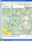
My question is referring to the numbers on the sectional that tell you the highest object in that area or box on the sectional...(forgot what they are called)..what I am wondering, is there anyway to tell what object it is that they are referring to...I notice its not in the same spot in each section so i thought maybe that was where the highest point is...

I know that you dont have to be 1000ft above that number ALL the time while flying through that area, and you just need enough distance laterally from whatever object it is, BUT to a pilot that is unfamiliar with that area, how would he/she know what and where that object was??

Ant
 
You just have to look in the quadrangle to find the highest object in it. Sometimes it is barely in the quadrangle, and sometimes it's smack in the center.

How do you know? Look carefully, sorry.
 
It's called the Maximum Elevation Figure. Also it is calculated as the maximum obstacle + possible vertical error (100) raised to the next 100'. If the obstacle is man made and more than 200' above the terrain then that's the number if not then add another 200'.

See the Aeronautical Chart User's guide: http://naco.faa.gov/index.asp?xml=naco/online/aero_guide for the details.

Ed is right to find it you have to search there's no special marking of which obstacle or terrain feature they used AFAIK.

Joe
 
As a general rule, it's highest obstacle rounded to the next 100 feet and 200 more added for the quadrangle elevation. This accounts for contours and obstacles under 200 feet not required to be reported. But, that number can still vary somewhat due to other obstacles. Read Page 2 from the following for greater detail.

http://www.naco.faa.gov/content/naco/online/pdf_files/7th_VFR_Intro.pdf

If you don't have a Chart User's Gude, get one. It's an important resource to have throughout training and beyond.

http://www.naco.faa.gov/index.asp?xml=naco/online/aero_guide
 
ok i thought that you just had to look, but i notice that MOST of the towers ect ect have thier height right next to them, and some dont...it seems some areas are so congested there is no way to see which one is the highest sinc ethey all dont have a number next to them...

does the rule about staying clear of high object change if you are in the vicinity of an airport?? i know that flying into some airports in my area there are VERY large towers very close to the airport...probably more then 1000 feet, but honestly..1000 ft isnt alot of distance when your flying

Ant
 
does the rule about staying clear of high object change if you are in the vicinity of an airport??
Sure. If you are in the process of taking off and landing, 91.119 says it's okay to run right into it. (Sorry. Couldn't resist.)
 
Sure. If you are in the process of taking off and landing, 91.119 says it's okay to run right into it. (Sorry. Couldn't resist.)
What Mark meant to say is that 91.119 has a big caveat up front that says, "Except when necessary for takeoff or landing..."
 
Sure. If you are in the process of taking off and landing, 91.119 says it's okay to run right into it. (Sorry. Couldn't resist.)
Dare I use you for a checkout should I come out there to rent while visting??? :D
 
The highest terrain in the grid is printed in a larger font than other terrain figures.

x 5,280

as opposed to

x 6,880
 
The highest terrain in the grid is printed in a larger font than other terrain figures.

x 5,280

as opposed to

x 6,880
I've never noticed that. And, I can't find the difference in my own area. All I have with me at the moment is off Skyvector.com.

The quadrangle where KGVL is located has an MEA of 28. The highest obstacle is the tower located just east of the WOMAC intersection. It's 2,654 MSL but the numbers are no larger nor bolder than the rest that I can tell.
 

Attachments

  • KGVL_Sect.jpg
    KGVL_Sect.jpg
    300.1 KB · Views: 25
The highest terrain in the grid is printed in a larger font than other terrain figures.

x 5,280

as opposed to

x 6,880
Thanks I never noticed or read that. It is a bit more subtle than your example though.

Joe
elevation.png
 
Some more trivia: an "x" signifies an unverified elev figure. A "." signifies a verified (surveyed) elev figure.

What is the significance of that to the pilot? Well, considering that the VFR charts continue to use the 1983 World Geodetic System, it can be assumed there may be a discrepancy between charted elev and actual elev.

This probably isn't anything to be concerned about except when flying in the big rock country.
 
I've never noticed that. And, I can't find the difference in my own area. All I have with me at the moment is off Skyvector.com.

The quadrangle where KGVL is located has an MEA of 28. The highest obstacle is the tower located just east of the WOMAC intersection. It's 2,654 MSL but the numbers are no larger nor bolder than the rest that I can tell.
You meant MEF, not MEA. I always thought the MEF was for terrain only and did not include man-made obstacles but after close study it appears your example does include obstacles. Another proof things are different down in Jawguh.

Look on the information cover page of your sectional. What does it say about HIGHEST TERRAIN elevation?
 
You meant MEF, not MEA. I always thought the MEF was for terrain only and did not include man-made obstacles but after close study it appears your example does include obstacles. Another proof things are different down in Jawjuh.

Look on the information cover page of your sectional. What does it say about HIGHEST TERRAIN elevation?
Oops, I'm so used to thinking "MEA" from Low Altitude charts, I automatically did it here.

This is what's at the margin of the Atlanta sectional:
"<snip> The MEF is based on information available concerning the highest known feature in each quadrangle, including terrain and obstructions (trees, towers, antennas, etc.)."

Beyond that, I got the data from the chart guide as referenced earlier. I think the general reference works well regarding the possibility of unreported structures under 200 feet. So, you really only have 200 feet clearance under the MEF.

But, using that number without being careful of its derivation can be dangerous if one is used to Low Altitude IFR charts. "Off Route Obstruction Clearance Altitudes" (OROCA) are derived from rounding up the highest obstacle to the next hundred feet then adding one-thousand feet in non-mountainous areas and two-thousand feet in mountainous areas. Because of the latter, the OROCA in my quadrangle is 7800 while the field elevation is only 1,275.
 
But OROCA on Lo Alt IFR Charts should not be confused with MEF on VFR Sectionals.

Or should it?
 
But OROCA on Lo Alt IFR Charts should not be confused with MEF on VFR Sectionals. Or should it?
OROCA on L-charts and MEF on Sectionals are two entirely different numbers computed in two entirely different manners for two entirely different purposes. Caveat aviator.
 
OROCA on L-charts and MEF on Sectionals are two entirely different numbers computed in two entirely different manners for two entirely different purposes. Caveat aviator.
Yes, quite true. What I'm getting at is a pilot not remaining clear or self-informed on how these numbers are derived. The scenario could be an instrument pilot who rarely flys under VFR. Time goes by and he grabs a sectional then makes a VFR flight.

He could automatically think he has a thousand feet clearance with the quadrangle numbers on the sectional. Add to that a slight altimeter error and he has no clearance at all above the highest obstacle in that quadrangle. Will it happen? Not that likely. Could it happen? Absolutely.

How many think they will never make an accidental gear-up landing in their flying career? It all comes back to vigilance in looking at what we're reading and how to interpret it.
 
Some more trivia: an "x" signifies an unverified elev figure. A "." signifies a verified (surveyed) elev figure.

What is the significance of that to the pilot? Well, considering that the VFR charts continue to use the 1983 World Geodetic System, it can be assumed there may be a discrepancy between charted elev and actual elev.

This probably isn't anything to be concerned about except when flying in the big rock country.

I think the latest version of the World Geodetic System is WGS84- expires in 2010?

In very simple terms, all WGS does is provide a surface of the earth that everyone agrees is at "0" altitude in the shape of a spheroid. Objects are measured in terms of altitude above this model earth.
 
I had a thought while reading this thread.... it is true that the number refers to the highest obstacle in the quadrangle, but finding that object doesn't seem too useful -- there might be 20 more just a little bit shorter, spread out all over the place.

The goal isn't to find the tallest obstacle, it is to find all the obstacles that could be a problem for the flight.

--david
You'll find the tallest but the MEF might be as much as 291' higher in real numbers. If your highest obstacle is 1765', they will round up to 1800' and add another 200' making the MEF 2000' or displayed as "20."
 
I had a thought while reading this thread.... it is true that the number refers to the highest obstacle in the quadrangle, but finding that object doesn't seem too useful -- there might be 20 more just a little bit shorter, spread out all over the place.

The goal isn't to find the tallest obstacle, it is to find all the obstacles that could be a problem for the flight.

--david
You're right about that. The goal is to know your bearing from the obstacle. As Cap'n Ron says, caveat avaitor. The MEF as well as the highest point as well as the colorations on the sectional chart all are useful in pointing out dangers. But those last are probably more useful in the land of the big rocks. Flying in the rocks means you might be in a grid that has an MEF of 113 but because of changes in terrain elevation you can safely navigate your route way below that. Situational awareness.

There in the midlands you may not have terrain issues but the towers are the dangers. Man, it's like everybody and their brother has their own tower. So, if you are above the MEF with the correct altimeter setting you SHOULD be okay. But if you are down that low you should be expecting something creeping into your 12 o'clock. Eyes outside after becoming acquainted with all available information.
 
And at least you can see the big rocks out west. Sometimes the towers are a real bear to pick out.
 
well i wanted to know if there was an easy way to spot the highest obstacle on the sectional becasue if i am flying a vfr flight and dont want to enter some busy airspace to get to an uncontrolled feild i would fly under it...but in some areas this would be illegal since i would be too close to high objects...especially if the airspace i dont want to enter goes down to 1500 ft and the highest object in that area is 1200 ft....i want to know where that object is ..but then again if you think about this..they probably wouldnt put an airport that close to a large object ..or vise versa..am i wrong??

Ant

How about fly a safe altitude, talk to ATC, and get airspace penetration permission?
 
I think the key is that if its tall enough, it'll be on the chart IN MOST CASES. Avoid the towers marked on the sectional, check for updates to the sectionals (mentioned by Ed in flashchat as a reminder)...

Don't be scared off by busy airspace. They exist because of us, not in spite of us. If you can make a flight more safely by talking to ATC, do it.

I also think perhaps speaking with a CFI about this kind of stuff would help immensely. And I'm not one to tout the importance of CFIs often.
 
Last edited:
Oh, as Nick mentioned, CHECK FOR UPDATES! That means BOTH NOTAMs and the back of the AF/D.
 
well i wanted to know if there was an easy way to spot the highest obstacle on the sectional
There isn't.

becasue if i am flying a vfr flight and dont want to enter some busy airspace to get to an uncontrolled feild i would fly under it...but in some areas this would be illegal since i would be too close to high objects...especially if the airspace i dont want to enter goes down to 1500 ft and the highest object in that area is 1200 ft....i want to know where that object is ..but then again if you think about this..they probably wouldnt put an airport that close to a large object ..or vise versa..am i wrong??
Ahhh...the rest of the story.

First, the FAA has restrictions on high objects placed close to an airport, but that doesn't necessarily help you, because you could be traversing significant amounts of space to get to the airport. My suggestion is to plan your flight thoroughly, draw the line on the chart, and study the route. Circle any high objects that would affect your flight, and stay at least 2000 feet horizontally away from them (that's not much -- less than half a mile). This will also help you stay out of the "busy airspace," since the areas where such airspace goes down to 1500 AGL are usually pretty close to where it goes down to the surface, and your study will help you stay where you want to be and out of the adjacent surface area.

In addition, check the sectional chart updates in the back of the A/FD for any additional objects that may have been erected since the chart was published up to six months ago, and pencil them onto the chart.

Finally, EdFred's point is a good one -- while there may be legitimate reasons not to poke your nose into Class B/C airspace, don't let personal discomfort with flying in such airspace be one of them. If the only reasons you're ducking under are that you aren't comfortable working with controllers or you aren't conversant with the regs governing such airspace, getting with a CFI and becoming proficient in Class B/C operations would be a good way to expand your capabilities.
 
Another suggestion is to get a TAC (Terminal Area Chart) if you're going to be flying near Class B airspace. It's really helpful to see routes, landmarks, traffic corridors & etc.
 
Does everyone in here honestly.. First off--get the sectional out. *Actually* look at the sectional. AND get the CURRENT AF/D out..and actually LOOK for updates before every flight? I really doubt it. I've never seen a pilot do that.
 
When they start building towers that are 4000' AGL, I'll start looking closer.
 
Does everyone in here honestly.. First off--get the sectional out. *Actually* look at the sectional. AND get the CURRENT AF/D out..and actually LOOK for updates before every flight? I really doubt it. I've never seen a pilot do that.
When I print approach plates off the web I'll check the updates. But, the same should also be done for published, printed plates. Updates are possible every 28 days even though printed publishing is on a 56 day schedule. Of course, there are also NOTAMs which may affect data in any published material.
 
When I print approach plates off the web I'll check the updates. But, the same should also be done for published, printed plates. Updates are possible every 28 days even though printed publishing is on a 56 day schedule. Of course, there are also NOTAMs which may affect data in any published material.

I think that non-instrument rated Jesse is talking about Sectional Charts, like the question in the thread referred to...
 
Does everyone in here honestly.. First off--get the sectional out. *Actually* look at the sectional. AND get the CURRENT AF/D out..and actually LOOK for updates before every flight? I really doubt it. I've never seen a pilot do that.

I guess I'm just plane weird. Although first off, I plan it on AOPA flight planner, then look at current charts, (both sectional and LAE), then print current plates, then look in the current green book.

Then there's weather to look at...
 
When they start building towers that are 4000' AGL, I'll start looking closer.
They don't have to be that high. We have a 1,765' AGL (~2800MSL) tower about eight miles southeast of GVL. It indeed reaches up enough to get your attention. The LOC 4 GVL calls for only 3700' in the area. Approach usually vectors you in at 3000. So, even on IFR it pays to know data on a sectional in a given area.
 
we got a couple 2000 AGL towers just south of here too. thanks to them weve got a nice stepdown on our ILS. I think Jesse is talking mostly about doing familiar XC flying. He almost always flies to the same destinations. My answer of prep depends on length and familiarity of the trip. If Im going to Boone from Ames, thats 10 miles and Ive been there a billion times. Im not going to draw the line or look in the AFD for that. I know the runways and frequencies. The same if I fly to Estherville for Pizza. Ive done that cross country with most of my students. I know the distances, checkpoints, frequencies, everything. Hell I even did it in my glider. But if I go to EdFred's or somewhere else strange then out comes the map. It only takes a few minutes to figure out your course and calculate WCA and GS, etc.
 
I guess I'm just plane weird. Although first off, I plan it on AOPA flight planner, then look at current charts, (both sectional and LAE), then print current plates, then look in the current green book.

Then there's weather to look at...

me too... I use the sectional to plot the course I'll be taking (even if using GPS Direct To), then review the AFD... I usually also look at AirNav, print off the Kneeboard format for the destination from AOPA's website...

Then use DUATS for checking weather, NOTAMs, TFR's, etc... before calling Flight Service...
 
There are some cross countries for me that simply do not justify planning on a sectional. I will usually have them with me but that's the extent of it. As long as I'm in VFR conditions there is simply no way I won't make it to my destination.

There are some cross countries that are in unfamiliar territory. These I will get a sectional out. I will usually draw a line. I will look at the course with my eyes and look for things that could be a problem. I'll generally glance in the AF/D. After that I'm in my car and driving to the airport. I always call flight service on the drive to the airport. In the airplane I track my location on the sectional by keeping my finger where I think I am.

I've done a fair amount of cross country with very equipped airplanes that have a Garmin 530, Stech 55, etc. I've also done cross country with nothing but a compass. Different airplanes, different cross countries, plus a number of other variables will determine how I plan.
 
Dont get me wrong, I do check the sectionals, but I don't go digging through the green book for additional towers. I'm rarely flying that low to the ground to worry about them. And if I am, the viz is good enough that picking out the towers is pretty easy.
 
Dont get me wrong, I do check the sectionals, but I don't go digging through the green book for additional towers. I'm rarely flying that low to the ground to worry about them. And if I am, the viz is good enough that picking out the towers is pretty easy.

The trouble is avoiding the barns...
 
Back
Top