sectional help

Jhernandez04

Line Up and Wait
Joined
Jul 13, 2012
Messages
955
Location
Arlington
Display Name

Display name:
TheHulk
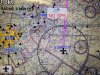
Please tell me what the black triangles are. Any other information is helpfully too.
 
You would have to live in an area of seriously bad weather to have those printed on a sectional.
 
Sorry guys they are on my Naviator app. I just don't understand a few things I tried to post a screen shot but it didn't work.
 
I figured a black triangle could only mean a few things....not sure though
 
Could be IFR reporting points. Check out a low en route sectional and see if the triangles are in the same places.
 
Sarcasm is not needed, nor did I ask for it.


Sorry.... I was just guessing... I have been flying 30 + years and so far, I have NEVER seen black triangles on any sectrional I have used.....

Let us know what it turns out to be..

That or maybe rename the thread title : Black triangles on my sectional app...
 
I took a pic with my phone and emailed it to myself.
 

Attachments

  • photo.JPG
    photo.JPG
    563.2 KB · Views: 118
Seems to be some kind of waypoints. Check you setting if you have them and see what is set to be displayed.
 
I clicked off intersections and they disappeared.
What are intersections in aviation terms?
 
Virtual navigation fixes. Basically just points in space that represent locations. Mostly used for IFR Navigation.
 
Definitely not official chart markings; part of the app.
I like the waypoint theory because they are apparently part of the same overlay that highlights ground-based navaids, many of which are available as standard GPS waypoints (I see a VORTAC and an NDB with black outlines; they are not black on sectionals).
Can't tell, though, if the black triangles jibe with any GPS or VOR-intersection waypoints, which are often marked (in blue) on sectionals. So maybe not. They actually look like they could be user-inputted waypoints...?
 
Sarcasm is not needed, nor did I ask for it.
Sarcasm was definitely due. This is not a printed sectional but a computer application. Any and all symbols are task related. You need to check with the guy who sold you the app or RTFM.
I hope your checklist reading is more thorough.
 
Those are listed in Naviator as IFR reporting points, enabled (as you said) by turning on the "intersections" layer. This layer is turned off by default, and as a primary student (which i assume you are) you should probably leave it off. Then again as a primary student you may want to stick with studying a paper sectional with a legend until you fix in your mind what one looks like. There are some things that a GPS enabled device won't do for you. Basic knowledge of sectional reading is one of these things.
 
Time to put down your mobile and pick up the FAR/AIM and your pilot's handbook.
Not being sarcastic, BTW... :)

Hey.. I didn't axe the original question.. I was just the one with the smart a$$ answer.
 
I clicked off intersections and they disappeared.
What are intersections in aviation terms?

Look at the black triangle located above the D of OLD. Note how it is located where two blue lines intersect. Those blue lines represent airways. One of those airways is a radial at 040 degrees from the VOR station located just north of KSAT. The other airway is a radial from some other VOR station. In this case, the waypoint is called an intersection because the two airways intersect there.

However, not every waypoint for IFR flight is an intersection of airways, as you can verify by noting that some of the black triangles on your chart do not lie on a blue airway.

Besides sectional charts, which are intended for VFR flight, there are also en route charts intended for IFR flight. For the region of interest for your chart, here is the enroute IFR chart, and here is the sectional VFR chart. Notice that on the IFR chart, intersections are indicated by black triangles (which unlike your example are not solid black triangles, but open ones).

Hope that helps.
 
Last edited:
Boys, at least he asked.
The only dumb question is the un-asked one.
However, this IS symptomatic of the iPAD approach to flying....Ben and Rottyd are correct. BACK to the books for you. You do own an AIM, yes?
 
Last edited:
You can download the FAAs chart users guide. It is a comprehensive guide to sectional and chart symbols.


Looking at the screen grab, I'd guess they are obstacles. There is also one oversized VORTAC.
 
It has me wondering about the quality of the software. In addition to the clunky overlay graphics, things don't seem to be placed quite right. This is the sign that they don't understand the cartographic principles quite right.
 
Back
Top