Sandel 3308 and Garmin 430

jnmeade

Cleared for Takeoff
Joined
Sep 25, 2005
Messages
1,221
Location
Eastern Iowa
Display Name

Display name:
Jim Meade
Curious if any of you have flown with these two instruments together. I'm curious as to how you've customized either display or if you have accepted the defaults? It would seem logical that they not be repetitive so I'm simply curious as to which data you prefer in which instrument?
 
Paging Dave Siciliano.

He has this combination in his P-Baron (actually, a 430 and a 530, along with the 3308).
 
Curious if any of you have flown with these two instruments together. I'm curious as to how you've customized either display or if you have accepted the defaults? It would seem logical that they not be repetitive so I'm simply curious as to which data you prefer in which instrument?

I've got both in my bonanza. It's always in gps auto mode. I keep the display set to just show my course line with very few map features enabled. It's a great little instrument but as a map - not so good. I fly with a tablet PC with current charts, plates, weather, etc. so the map feature on the 3308 isn't really needed. I like having the course deviation indicator on the bottom of the display - I'm not even sure if that can be turned off. You can play around with using the bearing pointers between gps and vor settings. It get get crowded with the course indicator, both bearing indicators and the map all turned on. I really like having it. I can't imagine going back to a mechanical HSI or DG.
 
I pretty much do the same as Dave above; although, I usually take it out of the GPS auto mode for an ILS approach. Otherwise, I use it to fly off the GPS to which it's connected and use the other GPS information on a CDI.
I have on occasion used a bearing pointer to keep track of a nav aid if it was important.

I normally keep the two GPS units in cross-feed mode so I just have to enter information into one, but have it feed into the other. Sometimes, on an ILS approach where I may be visual I take the units out of cross feed and set up the full approach on one (with way points) and just tune the localizer on the other in VLOC mode. That way, if approach turns me in early for a visual, where one unit goes into suspend mode because I don't overfly a way point, the other still has the localizer and GS for reference. I've had a couple occasions where I missed a way point and the units were in susp. mode when I really still wanted them for reference while being sure I was lining up with the runway properly even though in visual conditions. I didn't want to enter the approach on short final with limited visibility.

I also do the same thing when not sure I will get a visual v. an approach. Just don't want to miss a way point and have a unit (s) in suspend mode.

Best,

Dave
 
Do you both duplicate the info such as hdg, dtk, on both the 3308 and the Garmin? The stuff around the periphery of the 3308.
 
I think so. The auto-slew of course is on for nav direction; I can look at the date I have in the top of the 3308 to confirm, but heading for sure. I've attached a pic from a flight so you can see how we have it set up. If it's not clear on there, I can look at the plane and see if it's clearer.

I'm also attaching a pic showing what the Garmin displays were at the time.

Best,

Dave
 

Attachments

  • Picture 006.jpg
    Picture 006.jpg
    1.4 MB · Views: 48
  • Picture 005.jpg
    Picture 005.jpg
    1.5 MB · Views: 35
Last edited:
Do you both duplicate the info such as hdg, dtk, on both the 3308 and the Garmin? The stuff around the periphery of the 3308.

Jim,
I really don't have a good answer for you. I was flying for a bit with the data boxes turned off on the 430 and using the sandel but one of the data boxes I really like in the 430 is the vertical speed for decent planning so I keep the boxes turned on. I might switch it around. Are you planning on adding one or do you already have one? It's easy enough to configure so I'm sure you'll settle on something you like and then change it, and change it again. There's just too many buttons to not push them:yesnod:

I think so. The auto-slew of course is on for nav direction; I can look at the date I have in the top of the 3308 to confirm, but heading for sure. I've attached a pic from a flight so you can see how we have it set up. If it's not clear on there, I can look at the plane and see if it's clearer.

I'm also attaching a pic showing what the Garmin displays were at the time.

Best,

Dave

Dave,
Although our Sandel 3308 may look the same and although we both fly the Beechcrafts, there's numbers on your altimeter that I will never see:rolleyes:. What a capable aircraft!!!!
 
So far, I like the CDI on 430 #1 and the map on 430 #2. Much of the data off the CDI page is on the Sandel, but maybe not so easy to see. So, I could turn off all data on the map page and customize the data on the CDI page to not duplicate the Sandel. Of coures, the Sandel can be changed, as well. Looks like I'll have lots of fun playing with all this stuff.
 
Dave,
Although our Sandel 3308 may look the same and although we both fly the Beechcrafts, there's numbers on your altimeter that I will never see:rolleyes:. What a capable aircraft!!!!

I love the 58P. Best plane I can find for the longer cross country flights I make. I flew a TN A-36 for about five years that could perform many of the missions, but the K-Ice, pressurization and redundancy really has allowed me to fly in conditions I wouldn't have gone in with the A-36. Hope you get to fly one sometime if you haven't.

We had a bit of a tail wind on this day.

Best,

Dave
 
Dave,
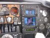
Did you ever explore all the various configuration so the 3308, or decide that with the Garmin you didn't need to? On one hand I'm intrigued by all the possibilities and on the other I wonder if I'd ever use them. Four, actually 5 map views, with A-B alternatives, all the various pointers, etc.
Do you ever fly the 70 deg arc or always the 360, and if you prefer one over the other, why? I end up flying the 360 because I kind of forget about the 70. Guess I ought to try it, but I have map view on the #2 430.
The 33008 is such an interesting instrument that I'm still exploring it, as you can tell.
I take it that a power failure means the instrument is dead, blank, unreadable?
Do you know if it still performs various functions with a bulb burn-out, even if you can't see it?
 
Jim: I pretty much used the Sandel as an HSI. I've never had a bulb burn out; only received the 100 hour warning and replaced it. In the Baron, a complete electronics failure is pretty low percentage. I've lost an alternator in flight. We can also have two electrical buses and an emergency power bus. Hopefully, I'd still have battery power for awhile. Even then, like Ron, I carry and ICOM hand held and Garmin 496 as back up to all that.
I played with the Sandel when I first got it and found with the GPS units, it just didn't add much. I have weather on the 496 and on-board RADAR on the 58P. Just didn't need the display in another place IMO. I have sent a needle to track a VOR on occasion, but find that the 530 with the VOR distance and bearing I really don't need that.

I sure could see it being helpful if I didn't have the other equipment that I do.

Best,

Dave
 
Dave,

I take it that a power failure means the instrument is dead, blank, unreadable?
Do you know if it still performs various functions with a bulb burn-out, even if you can't see it?

Yes, a power failure renders it inoperative. If the bulb fails, it still works but you can't see any of it. I had a bulb burnout so now I carry a spare in the plane in case it blows out when I'm away somewhere.
 
In cruise, I like the Sandel in 360 degree mode, showing nearby airports. If I should need to turn to one, this makes it real easy to see whether it's a left or right turn.

On takeoff, I like the 430 on nav page 4, which reports ground speed to cross-check against the ASI.
 
In cruise, I like the Sandel in 360 degree mode, showing nearby airports. If I should need to turn to one, this makes it real easy to see whether it's a left or right turn.

On takeoff, I like the 430 on nav page 4, which reports ground speed to cross-check against the ASI.

I see your point on the Sandel in cruise. What range do you like? I'm thinking I can run the map on my #2 430 at 35 miles and the Sandel at maybe 10.

The 430 Nav page 1, default page, also has GS as the lower left of the six data items. Is there something else you like about page 4?

One of my interests is maybe changing some of the user defined fields in nav page 1. For example, I could put Vertical speed required (VSR) there, perhaps in lieu of BRG, which is also on the Sandel.
 
Back
Top