Rocks 2 Departure, North Las Vegas

TangoWhiskey

Touchdown! Greaser!
Joined
Feb 23, 2005
Messages
14,210
Location
Midlothian, TX
Display Name

Display name:
3Green
While reading the Safety Pilot article starting on page 60 of the December '09 AOPA Pilot, a question arose. The article describes an incident from Nov 8 2007 in which two highly experienced CAP pilots flew their G1000 C182T into the side of Mount Potosi enroute to California from North Las Vegas on a clear VFR night.

The article's summary mentioned that "the Las Vegas Terminal Area Chart has a prophetically named VFR transition route, the Rocks 2 Departure, that keeps VFR aircraft safely away from terrain until they are clear of McCarran traffic and can climb to a safe altitude."

So off to SkyVector I went to look at the TAC. Snippets below, and my question is:

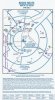
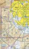
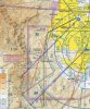
The ROCKS 2 DEPARTURE instructs pilots leaving VGT to proceed "direct to the Blue Diamond Gypsum Mine climbing at or below 6500'. Passing Blue Diamond Gypsum Mine proceed south to abeam Jean Airport, radar service is automatically terminated, squawk 1200, resume appropriate VFR altitudes remaining clear of the Class Bravo Airspace, frequency change approved." A note at the top of the procedure says to contact Las Vegas approach on 133.95, so that, along with the note that "radar service is automatically terminated, squawk 1200" certainly implies you'll be talking to Approach and be on a discreet squawk during this VFR departure route.

However, I can't help but notice that proceeding south of Blue Diamond Gypsum Mine at or below 6500' is going to take you inside the SW sector of class Bravo airspace, whose floor goes down to 5000. Definitely don't want to be BELOW 5000 there, due to the proximity of the 5695' MSL peak just south of OASYS intersection.

Flying this route, at 6500 southbound from the Mine, do I need to hear the magic words "cleared into Class Bravo" from the approach controller? I'd inquire, of course, to be sure... but technically, do you need to?

The note in the departure text to 'remain clear of Class Bravo Airspace' applies to the route after abeam Jeans Airport, proceeding on course.

attachment.php


attachment.php
 

Attachments

  • ScreenShot047.jpg
    ScreenShot047.jpg
    94.4 KB · Views: 157
  • ScreenShot046.jpg
    ScreenShot046.jpg
    128.3 KB · Views: 155
Flying this route, at 6500 southbound from the Mine, do I need to hear the magic words "cleared into Class Bravo" from the approach controller? I'd inquire, of course, to be sure... but technically, do you need to?
Yes you do. When departing from VGT you may get the clearance will still on the ground from ATC. It sounds like this

Cleared VFR to XYZ via the Rocks 2 departure, Climb and maintain 6500 cleared into class bravo, contact approach on 123.45, squawk 1234. Other times you may just get the clearance to leave VFR and then would have to get the bravo clearence from departure.
 
Well, this is certainly one instance where using "all available information" is important. If you were to just read and follow the textual description without comparing it to the chart, you'd get a Class Bravo bust on your record...
 
Well, this is certainly one instance where using "all available information" is important. If you were to just read and follow the textual description without comparing it to the chart, you'd get a Class Bravo bust on your record...
It's an interesting situation. It would be better if there was a note on the chart saying that the ROCKS TWO ROUTE requires a clearance issued by ATC, and is not a route to be flown on your own without a VFR Class B clearance. I've got a call in to the Las Vegas FSDO to ask about that.
 
Last edited:
It's an interesting situation. It would be better if there was a note on the chart saying that the ROCKS TWO ROUTE requires a clearance issued by ATC, and is not a route to be flown on your own without a VFR Class B clearance. I've got a call in to the Las Vegas FSDO to ask about that.

There is. It also says "VFR only" and "Remain outside Class Bravo airspace". Those last two make the clearance requirement rather meaningless.
 
There is. It also says "VFR only" and "Remain outside Class Bravo airspace". Those last two make the clearance requirement rather meaningless.

The procedure mentions staying outside Class Bravo airspace twice... once with direct mention of "10 miles from the Las Vegas VORTAC", which covers the early part of the procedure, then again after abeam Jean airport, when radar service is terminated.

The portion of the route in question has Class Bravo out to 15 miles from the Las Vegas VORTAC, and below the altitude you are told to fly in the procedure. Below Class B along that route is unsafe due to the afore-mentioned 5695' peak south of OASYS.

So I still think there's confusion in the instructions--that could be clarified by better wording. I agree that the clearance is required.

One more thing... I can fly inside Class Bravo while VFR, so the "VFR only" isn't restrictive, especially since the procedure dictates being in radar contact with Las Vegas Approach.
 
One more thing... the procedure starts with the words "After receiving clearance,...", so what Scott said above may very well be what happens... you may get cleared into Bravo, for the portion of the route in question at 6000', when you receive that departure clearance.
 
There is. It also says "VFR only" and "Remain outside Class Bravo airspace". Those last two make the clearance requirement rather meaningless.
Since it's not possible to remain outside Class B while following the procedure and adhering to 91.119, there is a disconnect which needs fixing.
 
Very rarely can you get cleared via the Rocks 2.. either northbound or southbound.

IFR Departures from McCarran on Rwy25R go west, then either turn left towards LAX, farther left for PHX or straight over Red Rocks then NW to OAL, SFO and SEA or turn NE for SLC, DEN, CHI and Points east.

And if they are landing on Rwy 1 or Rwy 7, the Rocks 2 southbound climb puts you face to face with arriving traffic.

You can request the Rocks 2 from VGT Tower prior to taxi, the clearance will be a squawk code and a heading, normally 210 to the SW and "remain clear of Class B, contact Approach on freq xxx.x.

In the original OP, the accident in question, both pilots were very experienced and one was very experienced with the LAS valley and the surrounding terrain. It's a mystery to everyone why they hit that mountain.
 
Since it's not possible to remain outside Class B while following the procedure and adhering to 91.119, there is a disconnect which needs fixing.

Most people do not follow the Rocks 2 departure because of terrain. They'll go SW to Red Rocks, clear the LAS 10nm Arc, turn south and start climbing, remaining clear of the Class B.

If they have enough "light" to see the hills, head towards Cottonwood pass and get above 9K MSL to clear the Class B, if you can, Clear the LAS220015 corner to the west, stop below 8KMSL and keep going south until clear of the 20nm arcn and then continue the climb, Mt Potosi will be behind you by then.

If you are not comfortable to the hills, again from Red Rocks, stay below 5K MSl, at Blue Diamond, head towards the "Ruins", pick up the high tension power line thru the valley towards Jean. 1/2 between Blue Diamond and the Ruins at 4500ftMSL you can get a visual on Jean. Clear each 15nm and 20nm arc and climb accordingly. Keep in mind if McCarran is landing Rwy 1, you will have big airliner traffic head on and above you.

Terrain clearance is a big issue, if you are not comfortable at night VFR in the valley or mountainous terrain, don't do it. If you are not "IFR Rated", VFR flight over the desert at night is not recommended.
 
One more thing... I can fly inside Class Bravo while VFR, so the "VFR only" isn't restrictive, especially since the procedure dictates being in radar contact with Las Vegas Approach.

VFR navigation checkpoints is the only way to Navigate the procedure, other than radar vectors from approach.

I was VFR from Jean to VGT at night last month. I called approach and asked for transition. I was denied Class B entrance, I asked for flight following as I went around the west side of Class B and was given a frequency change for flight following.

The new controller asked if I'd like to transition Class B via McCarran. Given a Squawk, proceed direct Henderson, Direct Approach end Rwy 25, Heading 270 outbound. Cleared Class B maintain 5000. At the approach end of 25 I was given direct VGT. The initial heading of 270 was to protect any arrivals to McCarran Rwy 19. Once I was there and no traffic.. cleared direct.
 
Since it's not possible to remain outside Class B while following the procedure and adhering to 91.119, there is a disconnect which needs fixing.

It is possible to remain outside Class B while following the procedure and adhering to 91.119.
 
The portion of the route in question has Class Bravo out to 15 miles from the Las Vegas VORTAC, and below the altitude you are told to fly in the procedure. Below Class B along that route is unsafe due to the afore-mentioned 5695' peak south of OASYS.

Why do you feel it's unsafe? The procedure does not require flight over that peak and there's 2300 feet between it and the Class B floor.
 
I'm wondering why/how this procedure comes into play at all.

Every time I've departed LAS or VGT, I was either IFR or cleared into the class B on course. Has this changed?
 
Why do you feel it's unsafe? The procedure does not require flight over that peak and there's 2300 feet between it and the Class B floor.

There's no lateral nav guidance for "purple arrows". As you said, it's a VFR procedure. That hill is not lighted at night. Good luck not hitting it when you're trying to stay below the 5000' Class B shelf.
 
I'm wondering why/how this procedure comes into play at all.

Every time I've departed LAS or VGT, I was either IFR or cleared into the class B on course. Has this changed?

I have had instances of departing VGT and attempting to go towards the SE, towards Kingman and PHX in a small SEL. I was denied Class B access on many occasions and forced to circumnavigate the Class B to the West and then South until I could proceed on course and avoid the Class B.

It all depends on the active runways at McCarran and the density of their traffic.
 
It is possible to remain outside Class B while following the procedure and adhering to 91.119.
Since the procedure goes right over terrain near a 5600-foot peak, and you have to stay below 5000 to stay out of the B-space, that's a rather disingenuous statement.
 
After speaking with both the Las Vegas FSDO and the Las Vegas TRACON Traffic Management Unit, it appears that there is a significant problem with the ROCKS TWO procedure, in that it forces traffic on that route straight into a 5000+ foot ridge below 5000 feet. Both the FSDO and TMU agree this is not as safe as it should be, especially at night. The procedure is also misleading in that it says to stay "at or below 6500 feet" at a point where you must remain below 5000 feet to stay clear of the B-space. Further effort will be required to resolve this issue, and that may become a part of an already-underway review of the B-space. I'll post more as I hear it.
 
Since the procedure goes right over terrain near a 5600-foot peak, and you have to stay below 5000 to stay out of the B-space, that's a rather disingenuous statement.

The procedure does not require flight directly over that peak and that peak is not below the 5000' Class B shelf.
 
After speaking with both the Las Vegas FSDO and the Las Vegas TRACON Traffic Management Unit, it appears that there is a significant problem with the ROCKS TWO procedure, in that it forces traffic on that route straight into a 5000+ foot ridge below 5000 feet. Both the FSDO and TMU agree this is not as safe as it should be, especially at night. The procedure is also misleading in that it says to stay "at or below 6500 feet" at a point where you must remain below 5000 feet to stay clear of the B-space. Further effort will be required to resolve this issue, and that may become a part of an already-underway review of the B-space. I'll post more as I hear it.

"At or below 6500 feet" applies to the segment between the Red Rock Retention Basin and the Blue Diamond Gypsum Mine.
 
Seems like flying about 2nm further west at 6500 solves all the issues.
 
Seems like flying about 2nm further west at 6500 solves all the issues.

If you make good a track of 180° from Red Rock Retention Basin you'll pass about 2 miles west of that peak and you won't fly under the 5000' Class B shelf.
 
If you make good a track of 180° from Red Rock Retention Basin you'll pass about 2 miles west of that peak and you won't fly under the 5000' Class B shelf.

Yep, flying magnetic south would do it.
 
Steve, my discomfort with the 5695' foot peak south of OASYS: As you said, the peak itself does not encroach on the 5000' floor of Class B, as it is under the 8000' shelf (barely). However, if I'm heading south from the Blue Diamond Gypsum Mine to abeam Jean, as described in the textual description on the TAC chart, my route (shown in green on the attached picture) would have me popping out from under the 5000' shelf awfully close (less than a 1/2 mile, marked with a red line) to that peak, and although it's under an 8000' shelf, my C172/C182 doesn't climb that fast.

You make a good point as an alternate route: flying 180 magnetic (not true) from the Red Rock Retention Basin would keep allow you to climb to 6500 without encroaching on Class B shelf. Assuming a good climb rate and holding your heading accurately, the 4920' terrain at Cottonwood pass would be cleared as well (of greater concern should be the even higher peak/ridge up by Blue Diamond), and one could turn south when > 15NM DME from the VORTAC and continue climbing up to < 8000', or even continue to hold the 180 heading and not hit terrain. I've highlighted that route on the map attached, in orange (headings taken off the VORTAC). One note: don't fly this after getting clearance to fly the Red Rock Two, or else you'll not be following the procedure--it dictates "direct to the Blue Diamond Gypsum Mine" after Red Rock Retention Basin, not heading 180.

In blue is the heading 210 the ATC transcript shows the fated pilots flew after departing VGT. Last radar return was at 7000' MSL.

attachment.php
 

Attachments

  • ScreenShot029_annotated.jpg
    ScreenShot029_annotated.jpg
    146.5 KB · Views: 56
Last edited:
You make a good point as an alternate route: flying 180 magnetic (not true) from the Red Rock Retention Basin would keep allow you to climb to 6500 without encroaching on Class B shelf.

Why is that an alternate route? If you were told by ATC to "fly heading one eight zero" you'd fly a magnetic heading of 180°, wouldn't you? The three digits of a course, bearing or heading are magnetic, the word "true" must be added if it's meant to apply. So why is "proceed south" assumed to be a true direction?

 
Last edited:
Why is that an alternate route? If you were told by ATC to "fly heading one eight zero" you'd fly a magnetic heading of 180°, wouldn't you? The three digits of a course, bearing or heading are magnetic, the word "true" must be added if it's meant to apply. So why is "proceed south" assumed to be a true direction?


I think the 'proceed south' instruction in the printed text of the departure procedure, after Blue Diamond, if that's what you are referring to, would tend to be interpreted as depicted by the accompanying graphic, which shows a true south, rightly or wrongly.

Good discussion.
 
After speaking with both the Las Vegas FSDO and the Las Vegas TRACON Traffic Management Unit, it appears that there is a significant problem with the ROCKS TWO procedure, in that it forces traffic on that route straight into a 5000+ foot ridge below 5000 feet. Both the FSDO and TMU agree this is not as safe as it should be, especially at night. The procedure is also misleading in that it says to stay "at or below 6500 feet" at a point where you must remain below 5000 feet to stay clear of the B-space. Further effort will be required to resolve this issue, and that may become a part of an already-underway review of the B-space. I'll post more as I hear it.

Ron,, "straight into a 5000+ ridge below 5000ft", that's why us locals dont' fly the Rocks 2.

Thanks for the call to FSDO. We have not heard anything out here on a Class B redesign other than for the air traffic impact study for a new airport south of Jean (Ivanpah). That airport has yet to be approved for funding.

Please keep us locals advised.
 
Last edited:
Steve, my discomfort with the 5695' foot peak south of OASYS: As you said, the peak itself does not encroach on the 5000' floor of Class B, as it is under the 8000' shelf (barely). However, if I'm heading south from the Blue Diamond Gypsum Mine to abeam Jean, as described in the textual description on the TAC chart, my route (shown in green on the attached picture) would have me popping out from under the 5000' shelf awfully close (less than a 1/2 mile, marked with a red line) to that peak, and although it's under an 8000' shelf, my C172/C182 doesn't climb that fast.

You make a good point as an alternate route: flying 180 magnetic (not true) from the Red Rock Retention Basin would keep allow you to climb to 6500 without encroaching on Class B shelf. Assuming a good climb rate and holding your heading accurately, the 4920' terrain at Cottonwood pass would be cleared as well (of greater concern should be the even higher peak/ridge up by Blue Diamond), and one could turn south when > 15NM DME from the VORTAC and continue climbing up to < 8000', or even continue to hold the 180 heading and not hit terrain. I've highlighted that route on the map attached, in orange (headings taken off the VORTAC). One note: don't fly this after getting clearance to fly the Red Rock Two, or else you'll not be following the procedure--it dictates "direct to the Blue Diamond Gypsum Mine" after Red Rock Retention Basin, not heading 180.

In blue is the heading 210 the ATC transcript shows the fated pilots flew after departing VGT. Last radar return was at 7000' MSL.

The "standard" routing from the VFR tower at VGT is "recommended heading 210, remain clear of Class B." Most pilots will take the initial 210 heading, remain north of the bank building, modified slightly to clear the 4000 corner at the LAS 280/008 and and climb accordingly.

If the OP pilots stayed below the Class B, they were late to start a climb coming out from under the 5000ft shelf west of LAS to clear the mountain.

As stated, they were very experienced pilots flying in known mountainous terrain. It is believed they were distracted by the G1000 system while programming a flight plan and did not have the MFD on the terrain map page.
 
Back
Top