hankrausch
Pre-takeoff checklist
- Joined
- Jul 15, 2008
- Messages
- 332
- Display Name
Display name:
GoodbyePOA
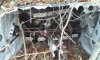
Hiking the AT today we came across this wreckage on the East side of the trail just below the ridge, near the Blackburn Trail Center on the WV-VA line. It was a low wing single engine with a fat chord and fixed gear, looked like a single central yoke, which still worked.
Anyone know anything about it?
It has to have been there at least 20 years.
Anyone know anything about it?
It has to have been there at least 20 years.
Attachments
Last edited:


![20141123_133019[1].jpg](/community/data/attachments/30/30174-07230d202bf6923dd17671bc313d8987.jpg)
![20141123_132332[1].jpg](/community/data/attachments/30/30175-77eaaaa3e0f8ab77063fa899e9f5bbcb.jpg)
![20141123_133509[1].jpg](/community/data/attachments/30/30176-9442f597d4b25d75b66964377d50f554.jpg)
![20141123_132810[1].jpg](/community/data/attachments/30/30177-a0238d9d242e3c0f6c6c67d72cdc95be.jpg)
 It has been a long time since I worked on a Cherokee down in the well, but the picture in my mind drops them down. The Beech's come from the floor.