Okay help me break down this one...
Let's try this step by step; apologies if I cover stuff you feel you already know well but I will try to emulate what might be a real life flight:
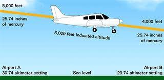
Assume the airport you plan to depart from is at sea level and happens to be in the area of high pressure described in your question.
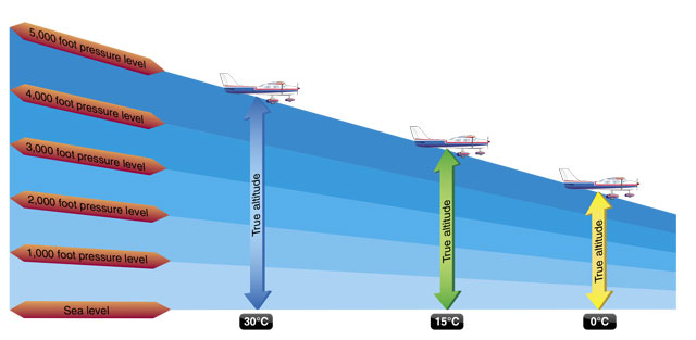
The altimeter senses the change in pressure as you climb higher and uses that to display a change in altitude. However the altimeter cannot distinguish between a high pressure air mass and a low pressure air mass;
it is calibrated to always indicate the same change in altitude for a given change in the pressure it senses. This is why the altitude shown by the altimeter is called
indicated altitude, because it can vary from the aircraft's true altitude
. High pressure air is more dense than lower pressure air, but the altimeter cannot tell the difference by itself. This is why the altimeter has an adjustable setting (the numbers in the Kollsman window) to allow the pilot to manually compensate for changes in local barometric pressure. On the ground, after you set the altimeter accurately for local barometric pressure, it will indicate the true altitude of the airport - in this case sea level or zero ft ASL.
Now imagine you take off and climb to a point directly above the airport where your altimeter is indicating 2000 ft ASL altitude. Your true altitude will also be close to 2000 ft ASL because you set the altimeter at the airport directly below just before you departed. If you now want to fly the airplane at a constant altitude along the coastline you will normally do this by referring to and maintaining a constant indicated 2000 ft ASL on your altimeter. As long as the local barometric pressure along your entire route remains the same as the departure airport (constant isobar) your true altitude will also stay constant, close to 2000 ft ASL.
Turning to the question, assume this same flight is made on a day when the local barometric pressure is not constant, but instead changes
"from an area of high pressure to an area of lower pressure". The lower pressure area is air with less density ("lighter"). Your altimeter has no way of knowing this, or adjusting for it by itself. If you do not adjust the altimeter setting, and you maintain a constant
indicated 2000 ft ASL on the altimeter, the airplane will be slowly descending, and your true altitude
will become less than 2000 ft (hence the "
From high to low, look out below" mnemonic). For the altimeter to read 2000 ft it needs the same air pressure as it had when the airplane was in the high pressure area directly above your departure airport, but as the airplane flies into the low pressure area you have to get closer to the ground to maintain that same air pressure in the less dense, "lighter" air.
The result is your true altitude above the sea level coastline you are following is becoming less than 2000 ft, even though the altimeter is still indicating 2000 ft ASL. So the answer is (B), the altimeter will indicate higher than the actual altitude above sea level.
") ).
).