You are using an out of date browser. It may not display this or other websites correctly.
You should upgrade or use an alternative browser.
You should upgrade or use an alternative browser.
Parallel Runways - Is distance between them published anywhere?
- Thread starter kontiki
- Start date
HPNPilot1200
En-Route
Not really. Try the measurement tool in Google Earth.
jpower
Cleared for Takeoff
Not really. Try the measurement tool in Google Earth.

Minimums are here: http://www.faa.gov/air_traffic/publications/atpubs/atc/atc0308.html#Tn850atc
To know what it actually is, Google Earth is probably your best bet.
oldShar
Cleared for Takeoff
How about the Airport Diagrams?
If not actual separation distances, the Diagrams provide the Lat/Long grid, so you can convert the grid to miles or feet and calculate separations (may have to use some trig if RNWYs aren't E-W or N-S, but shouldn't be a problem for pilots or some of the new fangled electronic gizmos to decipher)
If not actual separation distances, the Diagrams provide the Lat/Long grid, so you can convert the grid to miles or feet and calculate separations (may have to use some trig if RNWYs aren't E-W or N-S, but shouldn't be a problem for pilots or some of the new fangled electronic gizmos to decipher)
jpower
Cleared for Takeoff
...the Diagrams provide the Lat/Long grid, so you can convert the grid to miles or feet and calculate separations (may have to use some trig if RNWYs aren't E-W or N-S, but shouldn't be a problem for pilots or some of the new fangled electronic gizmos to decipher)
I have to say that Google Earth sounds a whole lot easier....
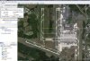
") . For example, at Dulles, centerline to centerline of 1L and 1C:
. For example, at Dulles, centerline to centerline of 1L and 1C:Attachments
MultiMediaWill
Pre-takeoff checklist
- Joined
- Oct 29, 2012
- Messages
- 246
- Display Name
Display name:
Will
Not really. Try the measurement tool in Google Earth.
How do you do this on google maps?
HPNPilot1200
En-Route
How do you do this on google maps?
I don't know if a way to do this in Google Maps. Only in Google Earth.
alfadog
Final Approach
How do you do this on google maps?
Doubt you can. You can get the lat/long of two points in Google Maps and use an online calculator to get the distance between two lat/long points.
Edit: You can use the "Draw a Line" function in Google Maps. You might have to be signed in. I am using Chrome but it worked fine for me at KTMB (3535 feet).
Last edited:
ZeroPapaGolf
Line Up and Wait
- Joined
- Jul 2, 2011
- Messages
- 647
- Display Name
Display name:
ZeroPapaGolf
You can do it in Google Maps by clicking My Places/Create Map/Draw Line

On airports where they're close enough to make simoultaneous operations interesting (like SFO) it's a note on the approach plate. IAD has like 6000 between 1C and 1R and as shown up there over 4000 between 1L and 1C.
MAKG1
Touchdown! Greaser!
- Joined
- Jun 19, 2012
- Messages
- 13,411
- Location
- California central coast
- Display Name
Display name:
MAKG
You guys are missing a REALLY important simplification.
You don't have a usable Google Earth while airborne. It only works with an active internet connection. You should have the A/FD.
Airport diagrams have two intrinsic easy-to-use rulers. One is that a nautical mile is equal to one minute of latitude. The other is that the runway length is labeled and to scale, fir all the runways.
kkoran
Pattern Altitude
Why do you need to know the distance between runways?Ref . Subject, I took a look in A f/d and in airport diagrams, if it's there, I missed it.
Ken Ibold
Final Approach
- Joined
- Feb 21, 2005
- Messages
- 5,888
- Location
- Jacksonville, Florida
- Display Name
Display name:
Ken Ibold
The airport's approved Airport Layout Plan is the definitive reference. However, getting your hands on one can sometimes be difficult. Some airports put them online; most do not.
jonnyjetprop
Cleared for Takeoff
I'd use the 10-9 jepp plate and measure the distance using the scale.