Ken Ibold
Final Approach
- Joined
- Feb 21, 2005
- Messages
- 5,888
- Location
- Jacksonville, Florida
- Display Name
Display name:
Ken Ibold
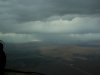
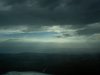
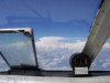
If not for the onboard Nexrad on my Garmin 496, I wouldn't have made it to OSH. Flying northwest out of Jax, eastern Georgia, the Carolinas and Va/W.Va were awash with storms that were predicted to be isolated, but popped up much earlier than forecast and in much greater number. However, it was early in the day, and they had not yet built up to Tstorms. The strikefinder was blank. The onboard Nexrad, however, was showing alarming amounts of red and even a purple spot scattered along my route of flight. Looking out the window, it was an ominous sight. The Nexrad picture, however, helped me pick my way around them. In days of yore, I would have hesitated to go around cells for fear of hitting a sucker hole, but with the radar pic you can see what's behind. Note I was in VMC for most of this leg, so I could reconcile the view out the window with the view on the screen.
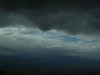
Made it up to OSH in "only" 6.5 hours. Did the OSH thing, and then it was time to come home. Departed ATW IFR and had to circle the airport to climb to 8000 before ATC would let me head on course past OSH. For this trip, I was heading west of Chicago instead of over Lake Michigan, because the nasty weather was piling up along my eastern route. South of Chicago, however, there was a repeat of the Carolinas situation, except this time a little more IMC. Still, I was able to make it around. The storms now were a little more mature and most were showing up on the strikefinder, enhancing my ability to spot them and verify the nexrad picture. Got to south Georgia, and found my path blocked by storms. ATC wanted to vector me between two, and had I not had the big picture I would have accepted the vector. However, I saw what he did not and opted for a run around the west that added significantly to my trip. A Bonanza flying behind me was not so fortunate, and ended up backtracking and eventually following me.
All told, 13.5 hours round trip, with about 8 in actual -- including the westbound leg over Lake Michigan. I used to be a little bit of a skeptic WRT Nexrad, due to lag times. But now I'm a believer.
")
 It is important to remember this is only one more tool in the toolbox when flying the flight until we develop the ability to move the weather as Diana wants. I can just see the fights developing to decide who gets to make the decision as to where the weather opens up.