Monday Flight

tonycondon

Gastons CRO (Chief Dinner Reservation Officer)
Joined
Mar 9, 2005
Messages
15,455
Location
Wichita, KS
Display Name

Display name:
Tony
AFter a great supper with the Lincoln folks Sunday the weather was pretty crummy for a night departure back to ames. clouds were a little cold to IFR it so student and I are sitting it out. We are looking at solid IMC for the trip home. Not exactly the training we had in mind when we left but it'll do. Heres the forecasts so far.

TAF:

Lincoln, NE:
KLNK 170524Z 170606 11009KT P6SM OVC100
TEMPO 0812 6SM -RA OVC025
FM1200 09010KT 5SM -RA BR OVC012
FM1400 08010KT 2SM -RA BR OVC006
TEMPO 1418 3/4SM RA BR OVC003
FM2100 06009KT 4SM -RA BR OVC007
FM0200 02006KT 2SM BR OVC005

Omaha, NE:
KOMA 170524Z 170606 13010KT P6SM OVC040
TEMPO 0812 5SM -RASN OVC015
FM1200 10010KT 4SM -RA BR OVC010
FM1400 10010KT 2SM -RA BR OVC006
TEMPO 1418 1SM RA BR OVC003
FM2100 07011KT 5SM -RA BR OVC008
FM0200 03006KT 3SM BR OVC008

Des Moines, IA (30 miles from home):
KDSM 170520Z 170606 10009KT 6SM -RA OVC040
FM0700 10009KT P6SM SCT040 OVC100
FM1100 11009KT P6SM OVC035
FM1400 11010KT 4SM -RASN BR OVC025
FM1600 10012KT 2SM -RA BR OVC012
FM2300 10008KT 1SM -DZ BR OVC008


Looks like it should be a low IFR departure but with good ceilings at destination.
Should be good enough weather to make a return ILS if needed at Lincoln or at Omaha

Heres the area forecast:
Nebraska:
S CNTRL/SERN...CIG BKN-SCT010 OVC040. CLDS LYRD FL350. VIS 3-5SM
-SN. BECMG 0508 CIG OVC010. VIS 3-5SM -RASN. OCNL -FZRAPL.
OTLK...IFR CIG RA PL SN.
Iowa:
WRN HLF...AGL SCT-BKN025 BKN080. CLDS LYRD FL350. OCNL VIS 4SM
-SN. BECMG 0609 CIG BKN-SCT015 OVC035. VIS 3-5SM -RASN BR.
OTLK...IFR CIG RA SN BR.
heres the prog chart for tomorrow at 1PM:

ll_18_4_cl_new.gif


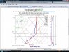
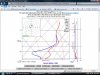
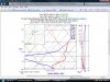
the sounding seem to show the same as far as freeing level, although currently the soundings only go to 1500Z they are showing
positive temps up to 7 or 8000. I cant figure out how to make a screenshot on Jesse's mac so i cant show the soundings.


anywho it will be interesting to see how the weather plays out. good lesson for my student to have to say no and spend the night.
 
interesting, the route at the moment is VFR but forecast to deteriorate over the next hour. The sounding for Lincoln at 9 AM looks like this:

attachment.php


temps above freezing! the Forecast Icing Potential is clear for the route below about 7000 feet which matches pretty well with the sounding.

the omaha sounding (actual sounding, not forecast) hasnt gotten up yet but the forecast sounding looks similar to lincolns. soundings at des moines and Ames look pretty much the same as Lincolns. looks like we should be able to go.
 

Attachments

  • untitled1.bmp
    1 MB · Views: 153
Sounds like a piece of cake. I got a chuckle about your mac comment. I'm like a monkey with a stick when it comes to running one of those things.

Be sure to follow up with your observations.
 
will do. lincoln is still saying 7000 BKN with temp of +3. I like that the actual ground temp is higher than what the sounding predicts. hopefully that will just shift the entire plot to the right a little. headed to the airport soon. Well be in N55350 if you want to track on flight aware.
 
landed about an hour ago. flight was good, we were able to stay right in the "nose" of the warmest air on the way over at 5000, dropping to 4000 closer to ames. I took good notes of temps/altitudes and cloud conditions along the way and will post those when I get a chance.
 
So how many hours of actual did your student end up getting?

Plus it looked like you got a pretty good tailwind.

Pete
 
yea we figured around 135 knots groundspeed. a little bit of actual. we went through a large area in between layers. i kept looking ahead thinking we were going to be in cloud soon but always ended up on top. mostly vis forward sucked but we could see down.
 
OK the run down.

Departure at Lincoln was into 4 miles Light rain and mist. 2400 Scattered with higher overcast. Temp 2, dewpoint 0 and altimeter 30.07 and "rapidly falling"

there was some moderate precip to the south that I wanted to get out ahead of. It didnt look super pretty on the radar, there was a sigmet for some stuff associated with it in Kansas, and it just didnt look like fun. Clearance delivery didnt have any icing PIREPS except for something over Omaha at 11,000. We climbed out and temps were pretty steady around 1/2 to 1 C in the climb up to cruise altitude of 5000 where temps were 2-3 C. We werent really in clouds, there was some scattered stuff under us and another layer above. Heres the sounding from departure and it pretty much mimics what we saw:

attachment.php


We picked up the victor airway out of Lincoln and headed towards Omaha. Eric did a nice job flying on instruments and we tracked well towards Omaha. Vis throughout the area was crummy, 3-5 miles and we were usually above scattered clouds. After the Platte River we were over solid undercast but still between layers. I recorded the temp over Omaha as 2 C at 5000, just barely on top of the undercast. Once we were east of omaha the clouds thinned back out and there were several holes but forward vis was still lousy. Here is the forecast sounding from Omaha about the time we were going over:

attachment.php


Our actual temp at that point was 2 C, it seems the soundings were just a bit cold.

As we got east of Omaha we started to get into some light rain. For pretty much the rest of the trip we were in some form of precip between a light mist and light to medum rain. Also started to get into some light turbulence as well. Up until Omaha it was dead smooth wtih not a single bump. Over Greenfield (West of Des Moines) I noted an OAT of 1 C and that was when we started getting vectors towards Ames from Des Moines approach. We were also given Pilots Discretion to descend to 4000. I held off descending as I wasnt exactly sure what position we were in the warm area and figured as long as I was in warm air I would stay there as long as I could. As we worked to the north the temp was dropping to an OAT of 0. Water was still running back on the strut and Des Moines said we would be out of the precip in a few miles. Eric and I discussed the plan that if we would start to pick up ice we would excercise our lower option and if that didnt give us warmer temps we would run back to the south (warmer air) with our tail between our legs and land at Des Moines. As with the rest of the trip clouds were thin and patchy but in the rain forward vis was basically nil but we could see down. A little further down I did start to see just a bit of rime on the leading edges so down we went to 4000 and the temps were back up to 2 C. We continued for Ames and were soon basically in the clear. Vis was about 10 miles but it was still pretty hazy. We took the vector for the ILS to 01 just so we would be sure of our position but were able to see the approach lights well outside the outer marker. The sounding in Des Moines for 1500Z shows pretty much exactly what we observed:

attachment.php


As we descended into ames the little ice we had melted off and temps stayed around 1 C until the ground. Automated weather was reporting 5 miles vis, temp 1 dew point -2 and 9000 overcast.

It was great to be home and the flight was a great learning experience for both me and my student. Its been a while since I had to spend the night somewhere due to weather and i think it was great to have a student along for the experience. Hopefully he will know how to say no when the time comes.
 

Attachments

  • 031708lnk.jpg
    031708lnk.jpg
    137 KB · Views: 117
  • 031708oma.jpg
    031708oma.jpg
    138.2 KB · Views: 114
  • 0317dsm.jpg
    0317dsm.jpg
    139.3 KB · Views: 116
Wow... I was picking up light rime in snow at 8 AGL this morning and I was going to wish you a safe drive home. Glad the flight worked out - what an excellent learning experience for your student! :yes: These threads are excellent learning experiences too, keep 'em coming!
 
Glad you had a good flight home Tony.

After chat last night I finally figured out how to copy the screenshot of the soundings. Here's a little experiment of mine. This is what the SkewT looked like when we landed at KAPA today. What do you think the conditions were? Bases, tops, icing?

Sounding.JPG
 
Last edited:
mari - id estimate cloudbase around 6000 MSL with clouds up to over 20,000. Icing probably up to around 15,000. any higher than that and i would suspect it would be too cold for ice. i have a feeling something different was happening?
 
mari - id estimate cloudbase around 6000 MSL with clouds up to over 20,000. Icing probably up to around 15,000. any higher than that and i would suspect it would be too cold for ice. i have a feeling something different was happening?
Actually, the bases were about 7000 MSL (the airport elevation is 5883), the tops were about 9000 MSL and it was more or less clear above. However in that 7000-9000 foot layer there was quite a bit of icing. I wouldn't have wanted to be there except in a FIKI airplane Here is a picture I took of the tip tank when we landed. Some of it has already melted off. I would say in certain places there was 1/2 to 3/4 inch and we were only in that layer for maybe 10 minutes while getting vectored for the approach.

TipTank.jpg


I don't think I have a good handle on reading these soundings. Like you I would have expected clouds up to about 20,000. It wasn't even like that 3 hours earlier when we took off and the storm hadn't moved as far to the east yet. At that time the tops were around 12,000 with no icing. Of course we didn't linger in the 7000-9000 MSL area and climbed through those altitudes in only a minute or two.
 
interesting mari. i love the picture btw. i guess its just like anything else where the soundings could just be plain wrong. they are forecasts anyway. did the other forecasts for the area jive with what you saw or with what the sounding said? hopefully scott will chime in here and tell us what we are missing...
 
did the other forecasts for the area jive with what you saw or with what the sounding said? hopefully scott will chime in here and tell us what we are missing...
Wish I had saved my weather, but as I remember, the area forecast had an AIRMET for moderate icing below FL180 and the freezing level was basically at the surface. That would jive with the sounding. I hope Scott chimes in too. :yes:
 
Is there some online document that tells you how to read those soundings? I am without clue.

David
 
Is there some online document that tells you how to read those soundings? I am without clue.
What I know I learned from this and also some of the other threads on this subject. Really I only know enough to be curious...

From what I can gather, if the red (temperature) and blue (dew point) lines are close together the humidity is high and you can expect clouds. You can also determine if the temperatures aloft are below freezing depending on whether or not the temperature line is to the right or the left of the diagonal 0 degree C line.
 
Last edited:
Ok, educate me, where do we find these skewT diagrams online?

Thanks, Mark
 
Just ask and ye shall receive. Course it costs a little green, but worth every buck.

http://chesavtraining.com/intro_to_skew-t.htm

I just ordered mine. I'm sure I'll recommend it as highly as everyone else does as soon as I get a chance to go through it.

Mari and Tony, I think the DEN sounding is what Scott would call a "cold sounding", which makes it difficult to use as a bases/tops prediction tool. I'd suspect that Scott would recommend looking at an IR satellite image to see the cloud top temperatures, and then look at the sounding to cross reference what altitude those temps occur at.

It's all just a guess until I get the CDs!
 
If you were landing at KAPA, then be sure to use KAPA to build the soundings.
OK, I didn't even realize KAPA had soundings.

Your chart shows 1900 UTC on March 17th. Is that when you were landing?
Yes, we landed at 1300 local (MDT). I should confess that this was an experiment after the fact. I took my actual landing time then went back and looked at what the skewT was for that time period since I was curious.

Were were you when you picked up the ice? Right near the airport? 30 SW?
I would say we were within 10 miles. We were getting vectors for the ILS approach.

Were the conditions "clear above" with very distinct tops when you broke out? Did the tops look a bit lumpy (like a quilted blanket) or were they fairly smooth?
Yes to both of those questions. I know those are stratocumulus clouds which have a tendency to have some ice so I was not that surprised. I just wanted to find out if there was any strong icing signature on the skewT since there was obviously ice in those clouds.
 
Back
Top