Long range forcasting

gprellwitz

Touchdown! Greaser!
Joined
Jun 19, 2005
Messages
12,762
Location
Romeoville, IL
Display Name

Display name:
Grant Prellwitz
Long range forecasting

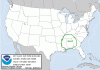
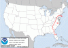
We all know that trying to make long range decisions based on weather forecasting can be problematic, but sometimes it's necessary. We're in Key West right now, and Leslie needs to be back in Chicago by Tuesday morning. Unfortunately, there's a slow moving system currently stretching from TX up through CO that's expected to make GA on north by Sunday and on into Monday. At this point, we're planning to leave early Sunday morning, make it as far north as possible, and resume the trip Monday.

Looking for others' take on this. Would you do the same? Try to do it all on Monday with the airlines as a fallback? Leave immediately?
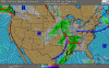
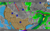
The convective outlooks don't look that bad, but we're unwilling to play with TR. That's why we stopped in SRQ on the way down Tuesday.
 

Attachments

  • TRSun420.gif
    TRSun420.gif
    16.3 KB · Views: 18
  • trMon421.gif
    trMon421.gif
    17.2 KB · Views: 18
Last edited:
At this point, we're planning to leave early Sunday morning, make it as far north as possible, and resume the trip Monday.

Looking for others' take on this. Would you do the same? Try to do it all on Monday with the airlines as a fallback?
As of what the forecasts look like now your plan seems reasonable.
 

Attachments

  • ScreenHunter_01 Apr. 17 19.40.gif
    ScreenHunter_01 Apr. 17 19.40.gif
    48.1 KB · Views: 11
  • ScreenHunter_02 Apr. 17 19.40.gif
    ScreenHunter_02 Apr. 17 19.40.gif
    48.4 KB · Views: 14
Scott, unfortunately leaving Saturday just wasn't something we could do. We made commercial reservations for Leslie out of Tampa, since she NEEDED to be back Tuesday, and I dropped her there Monday at noon and continued the trip myself. I actually would up making it all the way back on Monday, but it was better not having the "get-there-itis" hanging over my head that would have been there had she not gone back commercial. We landed at SPG in St. Pete just ahead of a storm that passed to the north with tops at 35K. We were watching that carefully to make sure we'd beat it in.

It was really nice being in a plane with both stormscope and nexrad, as it allowed me to suggest some diversions that kept me out of some isolated convective last night south of Terre Haute.

I also managed to get trace rime when the temp dropped from 2 to 0 as I entered a rain shower. Unfortunately, spotting that on a white plane at night is very difficult. I was able to see it against the black tire. Just requested and got a lower altitude and had no more troubles.

Plus the fact that I lost my IFR GPS for a while meant I had to switch from /G to /A, though I still had the 496 for situational awareness. The 496 also allowed me to restore the IFR GPS, because I was able to input initialization coordinates while in the air, which removed the flag. Apparently the internal battery was too low and it lost the system data.

A good trip, and I think I logged about 5 or 6 hours of IMC total. I'm REALLY glad I spent some time in the sim with an instructor the week beforehand brushing the rust off my instrument ticket! Didn't actually need to do any approaches, but a lot on en route WX decision making.
 
Sounds like an excellent trip, Grant. Thanks for the write-up!

Good example of the fact that GPSs can go out. That's one of the reasons why I always have VORs dialed into my NAVs as I'm going along, even on VFR flights. That way if the GPS goes out, I don't have to scramble looking for which VOR I'm near. It also helps to make sure I'm keeping good situational awareness of where I am and what's around me.
It's also a good example of why I didn't file direct to destination, but selected a few VOR's along the route. Made it relatively easy to switch to VOR navigation, even though they weren't along defined victor airways. I also had the route programmed into the handheld GPS, which still provided SA.

I'll say, though, that single pilot night IFR in the vicinity of even mild icing/storms does work to keep you on your toes!
 
Back
Top