azure
Final Approach
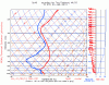
KVLL - KMIE, Sunday Jan. 20 at 1500Z
The forecast soundings show a shallow saturated layer capped by an inversion with temperatures at the tops anywhere from -15C to -10C. A strong cold front is coming through right now. The TAFs along the route forecast low VFR and high MVFR BKN-OVC ceilings with -SHSN. I read the soundings as suggesting a stratocumulus layer and don't find the snow showers very comforting since there could still be a lot of supercooled water near the tops. I'm planning to do this trip VFR because of this, even though I'd rather be IFR on a longer jaunt like this.
Thoughts?
Attachments
Last edited:
")