KPAO Advice

Goofy

Line Up and Wait
Joined
Nov 19, 2011
Messages
753
Display Name

Display name:
Goofy
Will be flying into Palo Alto for business weekly and am looking for advice on tie down availability either daily or monthly, general approach advice and opinions on weather in the vicinity. Wondering if there are any tricks to getting in, VFR, when the ceilings are low, how the mornings are this time of year etc.
Thank you! :yes:
 
mornings are the good time to come in. Down near Palo Alto the weather is generally good. Much more north like KSQL and especially KSFO there is a marine layer that likes to come in around 4pm. Along the coast the marine layer likes to linger all day but this year has been particularly nice and clear, a little bit of winds but nothing of concern.

I fly out of KSQL so im not sure about KPAO availability and tie down info.
 
It's not uncommon for PAO to be overcast in the morning. When it is, it can be difficult or impossible to get in VFR, because of the hills. The most reliable time to get in VFR is in the afternoon. I generally look at the SJC and SFO TAFs, and I figure that PAO will be somewhere in between them.

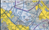
If you're coming from the east, a common way to do it is to come in through Mission Pass, which is where Interstate 680 crosses over the hills from the Livermore Valley. If you have a GPS, when you call the tower, you could report your position relative to the VPKGO waypoint, which is where the three radio towers are, just north of the Dumbarton Bridge, or relative to VPSUN (Sunol Golf Course), which is nearly in the pass. Coming from the north, you could fly east of the East Bay Hills, and then cross Mission Pass. Coming from the south, it's probably easiest to call Norcal Approach for a transition of the SJC class C airspace.

You shouldn't have any trouble getting transient parking. It's near the southeast end of the ramp.
 
Last edited:
Thanks guys. Looks like the most direct route is just west of Mt. Diablo and using the DECOT intersection for a straight shot at PAO avoiding Charlie. Unfortunately I have to come in around 6 AM, so if that's usually IFR I'll just have to keep going to KRHV and making the drive. Not bad but not optimal.
Thanks again.
 
If there is a marine layer, it isn't likely to spare RHV. Maybe LVK, but you may need to go as far as TCY. Not a fun drive in rush hour.

The marine layer frequently forms after midnight at the valley floor. Can you come the previous night?
 
If there is a marine layer, it isn't likely to spare RHV.

Especially at 6:00 AM. As you know, later in the morning, clearing tends to start south of the bay and work its way north.
 
Wondering if there are any tricks to getting in, VFR, when the ceilings are low...

Once you have good familiarity with the area, one trick when it's overcast is to circumnavigate the hills by coming in from the Sacramento River delta under the ceiling, requesting a transition through OAK's airspace. You will need to have both of the OAK tower frequencies ready. After coming in over the cities of Richmond, Berkeley, and Oakland, they would probably send you over the approach end of Rwy 29, and then over the midpoint of the San Mateo Bridge. (But not over the middle of the bridge's high span! That would put you in class B!) It's a little tricky to thread the needle between HWD's class D and SFO's class B surface area. I see they have a helpful GPS waypoint for that now, VPMID. This won't work with low ceilings though. You would need at least a 1600 MSL ceiling to be able to maintain the minimum altitude for a congested area while staying at least 500 feet below the cloud deck.

I would not want to do this for the first time at night. People have died on these hills.
 
Last edited:
With flight following, you can follow the shoreline to the toll plaza. That's inside HWD class D, but it's well off and above the pattern. TPA on that side is 600 MSL, and you'll likely be over 1000. Mid-span is probably better but BE SURE not to misidentify it; that's close to the Class B surface area in a really bad spot -- very close to the SFO outer marker.
 
Last edited:
You can also sneak into the bay under a marine layer via the Sunol intersection by staying north or south around KLVK airspace then proceeding SUNOL. There is a low point in the hills west of KLVK good for getting in and it avoids KOAK and Hayward. Careful as this is a busy intersection for traffic then head towards the shipwreck then onwards to KPAO.
 
Thanks again all! I've been going into KRHV Mondays at 6 AM and have been lucky so far with clear skies. One morning it was low ceilings all the way to Livermore then it cleared up!
Will try out these paths in the daylight in good conditions first. I'm familiar with all the landmarks but the shipwreck, where is that? I see one on the chart further north.... :dunno:
 
Shipwreck is in the bay between the San Mateo and Dumbarton bridges.
 

Attachments

  • shipwreck.png
    shipwreck.png
    3.9 MB · Views: 19
Once you're at RHV, it's easy to get to PAO under the ceiling if the clouds are high enough. SJC Tower generally sends you over the middle of their field, and then you follow Highway 101 to PAO. You can also get to the Palo Alto area from RHV using either public transportation, a cab, or a rental car.

http://www.vta.org/

As for the sunken ship, about three miles northwest of the KGO radio towers, there's a little line drawing on the terminal chart, depicting the bow of a ship sticking up out of the water. (That's not exactly what it looks like though.)

http://skyvector.com/?ll=37.511855,-122.249523611&chart=127&zoom=3
 
Why is the sunken ship relevant from Sunol? Local procedure is to enter at the east end of Train Bridge to avoid outbound traffic (which is over the Auto Bridge). Report in over Lake Elizabeth (IMPLY intersection).
 
Why is the sunken ship relevant from Sunol? Local procedure is to enter at the east end of Train Bridge to avoid outbound traffic (which is over the Auto Bridge). Report in over Lake Elizabeth (IMPLY intersection).

Well this is a typical pathway into KSQL from the SUNOL area but now that I am looking at the little map section that would be a bit too far north then necessary for KPAO. I was just going off memory. but The shipwreck is a nice position because you know you are not in any airport airspace until 2500 agl.
 
Looks like the most direct route is just west of Mt. Diablo and using the DECOT intersection for a straight shot at PAO avoiding Charlie.

I didn't notice this earlier. If you fly to DECOT, make sure you stay above 1500 MSL unless you are in communication with HWD Tower. A piece of their class D sticks out there.
 
Well this is a typical pathway into KSQL from the SUNOL area but now that I am looking at the little map section that would be a bit too far north then necessary for KPAO. I was just going off memory. but The shipwreck is a nice position because you know you are not in any airport airspace until 2500 agl.

For PAO, the sunken ship is often used as a reporting point when approaching from Hayward or Oakland.
 
Back
Top