labbadabba
Pattern Altitude
Assuming you weren't flying /G... in a C172
Lone Pine CA to Bakersfield - O26 -> KBFL
There are no radio nav aids nearby and the ones that are on the other side of the Sierra Nevada Mtns. MORAs are 16,800 and 12,200.
At this point, I'm thinking D-> China Lake VOR (why isn't this on the sectional), then Shafter VOR EHF. Altitude filed at 12,000 and would request 12,500 for the crossing over the mountains.
Bear in mind, this is a fictional flight plan, I'm just looking for challenges that I can find on the map.
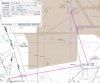