NoHeat
En-Route
I never learned to fly a departure procedure because my primary and instrument training was done where there are no DPs. So I'm trying to figure out what to do, in real life, when I'm given a DP.
Here's a concrete example:
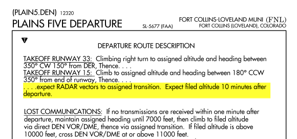
I was on the ground at KFNL (Ft. Collins Colorado) headed east to KIOW. Instead of clearing me as filed, Clearance Delivery gave me a clearance of Plains 5 to transition at TXC (which is a VOR), and some altitudes were also specified. (In real life, I declined this clearance and departed VFR since I didn't know what else to do.)
So how would I fly it in real life, assuming I've got a Garmin 430 and an autopilot, if that were my clearance?
Here's my guess -- please tell me if I'm anywhere close to correct:
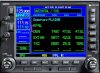
1. In my 430, in the flight plan menu, after entering my departure and destination airports (KFNL and KIOW), while still on the Flight Plan pages I push the MENU button to bring up a Page Menu and I choose Select Departure, and that generates a list of departures and I choose Plain5, which brings up a TRANS menu and I select TXC. (Hopefully I won't need to use any of this because I'll just get vectors anyway?) I then push ENT in response to the Load? query. The Flight Plan's first page now shows that the Active Flight Plan is KFNL/KIOW and below that it shows this list:
Waypoint
-- TXC
| Enroute
-> KIOW
2. After takeoff, if I have radio communication, I make a climbing right turn to the assigned altitude and heading, using the autopilot in HDG mode. Then I keep the autopilot in HDG mode and just take vectors until they eventually tell me to go direct to my destination. At no point do I actually use the DP that I programmed into the 430's flight plan.
3. If I lose radio communication I fly the route indicated in the DP (direct to DEN and then to TXC) -- and to get started I would set the autopilot to NAV mode, causing it to execute the DP that I previously selected.
Is that anywhere close to correct?
Here's a concrete example:
I was on the ground at KFNL (Ft. Collins Colorado) headed east to KIOW. Instead of clearing me as filed, Clearance Delivery gave me a clearance of Plains 5 to transition at TXC (which is a VOR), and some altitudes were also specified. (In real life, I declined this clearance and departed VFR since I didn't know what else to do.)
So how would I fly it in real life, assuming I've got a Garmin 430 and an autopilot, if that were my clearance?
Here's my guess -- please tell me if I'm anywhere close to correct:
1. In my 430, in the flight plan menu, after entering my departure and destination airports (KFNL and KIOW), while still on the Flight Plan pages I push the MENU button to bring up a Page Menu and I choose Select Departure, and that generates a list of departures and I choose Plain5, which brings up a TRANS menu and I select TXC. (Hopefully I won't need to use any of this because I'll just get vectors anyway?) I then push ENT in response to the Load? query. The Flight Plan's first page now shows that the Active Flight Plan is KFNL/KIOW and below that it shows this list:
Waypoint
-- TXC
| Enroute
-> KIOW
2. After takeoff, if I have radio communication, I make a climbing right turn to the assigned altitude and heading, using the autopilot in HDG mode. Then I keep the autopilot in HDG mode and just take vectors until they eventually tell me to go direct to my destination. At no point do I actually use the DP that I programmed into the 430's flight plan.
3. If I lose radio communication I fly the route indicated in the DP (direct to DEN and then to TXC) -- and to get started I would set the autopilot to NAV mode, causing it to execute the DP that I previously selected.
Is that anywhere close to correct?
")