How do you decide what altitude to fly at against a head wind?

narchee

Line Up and Wait
Joined
Sep 8, 2014
Messages
722
Display Name

Display name:
Long Blinker
Let's say you're in a piston turbo plane and have a wide range of altitudes to play with. In my experience the forecast upper winds and what I see seem to differ quite significantly in some cases. Also your TAS speed goes up for the same IAS so you have to take that in account.

I'm a bit of a fanatic in wanting to be at the most optimum altitude (it's the engineer in me) so I want to know what is the ACTUAL best altitude to be at.

This is the process I follow when going into a headwind (usually westbound):

I get a rough idea of how high I want to go from the forecast winds then add a nice margin to that (perhaps an additional 5000 feet). I then file for that altitude let's say FL220. I then depart and climb at a constant IAS. Let's say 110 knots. While climbing I take note of my GS. The GS will usually increase as I climb but at point it may stabilize then start to go down. The headwind will usually be increasing but so will the TAS so the GS depends on which one is "winning". Once I note that the GS has started to drop, I will then ask ATC for an amended altitude and go to the highest altitude that had the best GS that I had observed. Kind of complicated but I know then I'm at the most efficient altitude speed wise (I don't generally care about fuel burn). For the rest of the trip I then continue to monitor GS and either climb or descend based on what I'm seeing.

When flying with a tailwind I go as high as I can since then I have both TAS and the tailwind climbing so the optimal altitude is the highest I can get.

Kind of complicated I know but it keeps me something to do on an otherwise long boring flight :D
 
I just use whatever fltplan.com recommends
 
You know how to flight plan. Pick your destination, assume direct-to, and just do it. Assume a reasonable climb speed, like 90 KIAS in a 182 or 206.

If the distance is short, you just use 2000 AGL or something like that to clear the highest obstructions, as optimizing isn't worth the climb. If it's longer and the difference is big, it may be worth it.

The one time I try to optimize is if I'm crossing high mountains and I have to climb anyway. I'll decide to climb early or later depending on the winds.

The sweet spot even on an NA Cessna is nearly 8000 DA. There is still a lot of altitude to choose from.
 
It is very difficult to be precise without knowing the exact winds (not the forecast winds) at each altitude and the tas you will be getting also at each altitude.

Other factors for me are ride and rush; is the ride down low tolerable or is it too much for the pax. Alone, I will tough it out down low (where the hw is usually less) to avoid 15kts+ of wind, thinking I might be saving some time or gas. With pax, I will settle in for a long ride as I don't want them getting beat up (and complaining).

And, I don't do LOP in mine below 7.5K so I'd have to avoid a strong wind up high to justify going down low.
 
Fltplan.com will compute all this for you. Would be nice if ForeFlight did the same thing.
 
Foreflight does this. When you select your altitude, it will display the headwinds at 3000' intervals.
 
I look at the times/fuel burns in ForeFlight, then balance that against the increased likelihood and intensity of turbulence at lower altitudes considering how long I'll be getting beaten up down there and the turbulence tolerance of either me alone or the passengers I'll be carrying.
 
Foreflight does this. When you select your altitude, it will display the headwinds at 3000' intervals.


But it will not take into account that your plane may have a different cruise speed at different altitudes. There is only one "cruise speed" field


Sent from my iPad using Tapatalk
 
How much of a difference is your cruise speed at different altitudes?
 
I look at the times/fuel burns in ForeFlight, then balance that against the increased likelihood and intensity of turbulence at lower altitudes considering how long I'll be getting beaten up down there and the turbulence tolerance of either me alone or the passengers I'll be carrying.

Not to thread jack, but is there a rule of thumb on altitude over mountain terrain to avoid the turbulence? Last month flying from Denver to Salt Lake my wife and I got beat up pretty bad until getting past the mountains. I guess flying a 172 there really isn't much room to play with though, since the terrain is 9000ish. The headwinds were (if I remember right) between 25-30, so it was a tad rough for a while.
 
Not to thread jack, but is there a rule of thumb on altitude over mountain terrain to avoid the turbulence? Last month flying from Denver to Salt Lake my wife and I got beat up pretty bad until getting past the mountains. I guess flying a 172 there really isn't much room to play with though, since the terrain is 9000ish. The headwinds were (if I remember right) between 25-30, so it was a tad rough for a while.

Higher than you're going to get in a 172 in such conditions.
 
Not to thread jack, but is there a rule of thumb on altitude over mountain terrain to avoid the turbulence? Last month flying from Denver to Salt Lake my wife and I got beat up pretty bad until getting past the mountains. I guess flying a 172 there really isn't much room to play with though, since the terrain is 9000ish. The headwinds were (if I remember right) between 25-30, so it was a tad rough for a while.

ROT is that you want to be at least one-half the valley depth above the peaks. If the winds are 25 to 30 and yer in a 172 yer pretty much screwed.

I'd be happy to sell you a turbo Dakota that gives you a choice...as long as O2 is available...

For the OP, take the time to build the profile in DUATS and it does a pretty good job for estimating flight parameters...
 
Last edited:
ROT is that you want to be at least one-half the valley depth above the peaks. If the winds are 25 to 30 and yer in a 172 yer pretty much screwed.

I'd be happy to sell you a turbo Dakota that gives you a choice...as long as O2 is available...

For the OP, take the time to build the profile in DUATS and it does a pretty good job for estimating flight parameters...

If only..... working on a teacher's salary here isn't easy :dunno:
 
How much of a difference is your cruise speed at different altitudes?


Could vary by at least 20 knots or so in a normally aspirated aircraft going into the low flight levels to catch a tailwind.
 
I cheat and look at the EFIS, it displays instantaneous wind direction and velocity. So climbing out I can see if the winds aloft report is accurate, and stop climbing when Im happy with the wind.
Tim
 
Years ago I flight planned a 3-hour trip in a P-Baron at 4000 feet and FL180. Due to the time lost in the climb, it came out only 4 minutes faster at FL180 with no wind, even though TAS was substantially higher.

I picked FL180 because it was above turbulence, and because it's not one of the busier altitudes so I wouldn't lose as much time in vectors.
 
When I was flying the 421 I figured I needed to pick up something like 2 knots per 1000 feet over an average length flight to make it worth it to make up for the slower climb time and the higher fuel burn.

Lots of times I would cruise down at 4000 when I was empty...
 
depends - you got rocks in your way? Then you gotta go higher - but once the rocks are gone . . .

When I fly up north you usually see a headwind going up. Headings are usually 300 or so. Winds are 250v300 generally.

So I'll do 8500 to clear the rocks and then descend to 4500 once past Gorman - then when I get near Panoche VOR will go back up to 6500. You can zoom climb the first 1000' at 1500frpm and then do the next 1000 at 800-1000.
 
I use FlyQ by Seattle Avionics which has a winds optimizer function for flight planning. In flight the weather/winds page shows your current altitude and the winds. Pretty easy to choose.

If fact I use it almost every flight
 
I look at the times/fuel burns in ForeFlight, then balance that against the increased likelihood and intensity of turbulence at lower altitudes considering how long I'll be getting beaten up down there and the turbulence tolerance of either me alone or the passengers I'll be carrying.

Pretty much the same here.

I iterate between FF's winds aloft and my approx. TAS then cross check that with other stuff: terrain & IFR MEA/OROCA, turbulence, freezing level, oxy needs (supply vs demand), time and fuel to climb, OAT/oil cooling, pax health/ability to equalize their ear pressure.

Once airborne I usually will only climb if I encounter turbulence. My wife hates turb. So I place more emphasis on comfort than speed I guess. it is nice to have lots of altitude options.
 
Last edited:
I use foreflight's recommendations. Flying VFR, it's not unusual that my choice has more to do with where the ceiling is and my direction of flight than optimal wind speeds.
 
I fly as high as praticable in my Mirage. Often it is more efficient to fly low going west and high coming back east, however you have to consider the higher you fly the more landing choices you have if the engine gets wonky. Also depending on weather it can be better to fly slower over the weather than faster through it.

Occasionally when flying x-country it is faster to fly farther to avoid headwinds or pick up tail winds.
 
Sometimes there is more to it than just altitude.
https://www.windyty.com/?900h,wind,now,36.264,-95.828,4
attachment.php
 

Attachments

  • New Bitmap Image.bmp
    1 MB · Views: 123
Last edited:
If your flights are boring, why do you fly ?
 
Garmin pilot shows winds aloft, but the thing is, winds change faster than the software can keep up.

I've scudrunned on a VMC day at 1000' AGL across the plains into Hereford because that's where the sweetest spot was.
 
I use foreflight for the actual winds at altitude.decide to go higher or lower depending on the winds. Select the best overall altitude ,and go withit.
 
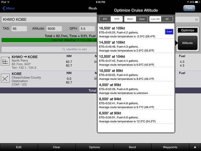
WingXPro7 has an "Optimize" button in the "Route Planning" page that quickly shows you GS/ETE and fuel required at different altitudes.


16542872469_1f8eef403d_z.jpg

Yes! That's a very handy feature.
 
Yes! That's a very handy feature.

No it isn't.

If you do the math, it isn't counting climb time. All the times are consistent with a total distance of about 85 nm and no climb. Fuel usage is also consistent with cruise only.

Add in the climb and most of the difference goes away.
 
Back
Top