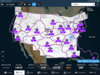
Some are much larger than others and have interesting boundary lines. How do they determine these boundaries? Seems like several Centers could be consolidated.

Interesting observation, I didn’t catch that. To me, it would seem like Jacksonville could consolidate with Atlanta or Miami and Ft Worth could consolidate with Houston.Note that each one has 1 or N Class B airports. except for jackson, but that’s on the borderline for Miami with 4.
Interesting observation, I didn’t catch that. To me, it would seem like Jacksonville could consolidate with Atlanta or Miami and Ft Worth could consolidate with Houston.

Interesting observation, I didn’t catch that. To me, it would seem like Jacksonville could consolidate with Atlanta or Miami and Ft Worth could consolidate with Houston.
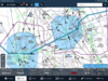
Here is an example of a surface boundary that is much different than the charted boundary in the Tampa - Orlando region. The magenta is the surface boundary and the blue course line is an overlay of the Miami charted boundary.
That looks like Forflight. How did you get that to come up?
A lot of those lines follow mountain ridges for obvious reasons.
")