Help with Route Review

shawjames

Filing Flight Plan
Joined
Feb 6, 2015
Messages
25
Display Name

Display name:
S. James
I have a progress check coming up, my last one! I was asked to plan a flight from KRHV to 2O1. Here is what I came up with, does anyone think this route could be better?

Route:
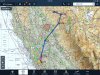
KRHV SUNOL SAC SIGNA SIDOY 2O1 @ 9,500

Detail:
depart KRHV for cruise at 9,500
to waypoint SUNOL
to SAC VORTAC on the 177 radial
from there, I want to avoid the TFR at Beale, so I plan to to waypoint SIGNA on the SAC 021 radial. The terrain gets a bit hostile here in the Sierras, my cruise altitude is to clear the MEF but I want to make sure I carefully to plan my descent into 2O1 at 3,419. Also, I want to avoid the CHINA MOA just west of 2O1, so my next wayout is SIDOY over the town of Portola. I need about 24nm to get down to 2O1, which is about the distance from this waypoint and over the winding highway 70/89 - plus there is an airport O02 near the final waypoint, good for diversion or fuel.


Looking forward to comments!
 
Flight plan route.
 

Attachments

  • image.jpg
    image.jpg
    1.4 MB · Views: 75
I don't like it. You're flying over 8000 foot terrain. Have you done this before?

The MOA is not a concern unless it's hot. You can also underfly the Beale TFR at 4000. Going over substantially more hostile terrain to avoid these is not called for. One of the "safety" airports you chose is routinely used to scare mountain training students. Despite the runway length, it's a short field due to the density altitude. Yes, it's about the same length as Reid, but it takes careful technique to handle that at DA up to 8000 feet or so, especially in 20 knot winds.

Follow the highway up from Oroville and do not overfly wilderness areas. To get past Beale, I'd use MYV VOR at 3500 unless the Class C was a problem. And if it is, you can still duck under at 1500.

Watch out for traffic leaving SAC at course 182 at the same altitude you're at. They can come at you FAST. And that's pretty close to the direct between KSAC and KRHV.
 
Last edited:
I don't like it. You're flying over 8000 foot terrain. Have you done this before?

The MOA is not a concern unless it's hot. You can also underfly the Beale TFR at 4000. Going over substantially more hostile terrain to avoid these is not called for. One of the "safety" airports you chose is routinely used to scare mountain training students. Despite the runway length, it's a short field due to the density altitude. Yes, it's about the same length as Reid, but it takes careful technique to handle that at DA up to 8000 feet or so, especially in 20 knot winds.

Follow the highway up from Oroville and do not overfly wilderness areas. To get past Beale, I'd use MYV VOR at 3500 unless the Class C was a problem. And if it is, you can still duck under at 1500.

Watch out for traffic leaving SAC at course 182 at the same altitude you're at. They can come at you FAST. And that's pretty close to the direct between KSAC and KRHV.


I have not flown over 8000 foot terrain before, this is a flight I was asked by an instructor to plan for a progress check. I do not think we will actually fly it, I'm sure he just wants to see how I would plan it.
I assume, the instructor wanted to see if I would plan the route over the high terrain or through the MOA... but more importantly why and how I would plan to do it.

For a flight through the MOA, I might plan around Sac to the West using the Williams VORTAC as my nav aid. Then over Oroville and up highway 70 as you pointed out, cutting over around Rodgers Flat, so:

KRHV ALTAM ILA CN26 2O1


The CHINA MOA is listed as active 0800-sunset daily.

I suppose the trade-off here is MOA vs High Terrain. I do not have experience with either, but when I study MOAs I often see this type of comment: "MOAs can be a point of debate for pilots and flight instructors. Some pilots recommend you avoid them completely, no matter how inconvenient. Others have no problem flying through them without a care in the world."


Since I am being tested, it might not be my opinion as much as the instructor. If he has issues with MOAs, then that route might not be the optimal answer, and vice-versa. If I do not know his opinion on the matter, then either answer could be correct as long as I properly plan it.


Maybe the MOA vs High Terrain could be a new topic? I will ask around my flight school to see what some of the others think.
 
Note that a VFR flight can go through a MOA anytime- just please let ATC know so they can deconflict any training.

An "Active" MOA isn't the same as a "hot" MOA- you can ask ATC when you get closer, but the probability of the box actually being used at any given point is slim.

It's just easier to list it as Active all the time instead of issuing a NOTAM everytime monthly training happens.
 
The first time you witness a takeoff at Blue Canyon, you'll need a change of underwear….

3300 feet isn't nearly as much as it sounds like at that altitude. All the airports around Lake Tahoe are easier (MUCH longer -- South Lake Tahoe is 8500 feet), despite the even higher altitudes.

Over the high Sierra, the flying is quite different in a 160 HP 172 than it is coming out of Reid. It can be done (and it's actually pretty easy on a calm wind day -- but not when it's blowing). Basically, you start depending on glider techniques, especially looking for rising air, in order to clear the terrain. You do not follow a magenta line or a VOR radial, but rather the terrain contours. You always want to be on the downwind side of any valley. If the wind isn't blowing uphill, you may not be able to maintain altitude.

And the winds aloft forecast can be wrong by 20 knots or more. You have to be able to "read" the winds. That's something you can practice around Reid. Half Moon Bay in particular is a good spot for that as the sea breeze/land breeze cycle can make winds 1000 feet up quite different from the surface. Wherever your instructor likes to practice ground reference maneuvers (south county? Tracy?) will work as well, as can a crossing over Mt. Hamilton. That's only 4000 foot terrain, instead of 8000.
 
Last edited:
I always thought they were synonymous. Same with cold and inactive.

What is the difference?

Colloquially they are used the same.

But the OP should understand the difference between standard hours the MOA may be used and when it actually is being used.

Just because it's listed as Active 0800-sunset daily doesn't mean there are jets in it constantly- OP should check with ATC to see what the actual status of the airspace is on the day of a flight. Even if a MOA is being used, deconfliction is usually workable.

Same as with R-areas and W-areas: they may be listed as Active 24/7, but often they are cold (no operations scheduled, airspace at ATC's direction) and in that case transiting is no problem. Just... don't go through them when they ARE hot and shooting off stuff.
 
Why would you chose a routing that minimizes your time over survivable terrain, and goes out of the way to extend your time over hostile terrain. This isn't very well thought out. Survival first, airspace second. Your most direct route can have you over safe terrain the majority of the time as well. Is there some reason you are circling east through the mountains only to turn west for a substantial distance? I'm not understanding the intent here. :confused:
 
I have not flown over 8000 foot terrain before, this is a flight I was asked by an instructor to plan for a progress check. I do not think we will actually fly it, I'm sure he just wants to see how I would plan it.
I assume, the instructor wanted to see if I would plan the route over the high terrain or through the MOA... but more importantly why and how I would plan to do it.

For a flight through the MOA, I might plan around Sac to the West using the Williams VORTAC as my nav aid. Then over Oroville and up highway 70 as you pointed out, cutting over around Rodgers Flat, so:

KRHV ALTAM ILA CN26 2O1


The CHINA MOA is listed as active 0800-sunset daily.

I suppose the trade-off here is MOA vs High Terrain. I do not have experience with either, but when I study MOAs I often see this type of comment: "MOAs can be a point of debate for pilots and flight instructors. Some pilots recommend you avoid them completely, no matter how inconvenient. Others have no problem flying through them without a care in the world."


Since I am being tested, it might not be my opinion as much as the instructor. If he has issues with MOAs, then that route might not be the optimal answer, and vice-versa. If I do not know his opinion on the matter, then either answer could be correct as long as I properly plan it.


Maybe the MOA vs High Terrain could be a new topic? I will ask around my flight school to see what some of the others think.

Consider it a test in ADM then. First off, just because an MOA is published as active, does not mean it is hot. You call to find out on you preflight brief, and before you penetrate. MOAs activities are often well above you, and the players will know you are there. I used to fly hundreds of miles of pipeline routes within active MOAs, there are additional hazards, however they are manageable.

Engine failure over hostile terrain is never good in a single engine plane, you want to minimize your exposure whenever possible. If you brought me that plan, I would know we needed to have a lesson on risk management.
 
Having flown that route before. I'd either continue following 80 all the way to KTRK(KTRK O79) or instead start at lake Oroville and follow the highway/river up, the China MOA wouldn't even factor into my calculations. Both keep you over roads and slightly less horrible terrain. The BAB TFR I'd just make sure I had flight following.

In reality, I wouldn't land at 2O3. I'd land at O02 because it's a nice big runway in a huge valley with plenty of space to climb and descend.
 
Why would you chose a routing that minimizes your time over survivable terrain, and goes out of the way to extend your time over hostile terrain. This isn't very well thought out. Survival first, airspace second. Your most direct route can have you over safe terrain the majority of the time as well. Is there some reason you are circling east through the mountains only to turn west for a substantial distance? I'm not understanding the intent here. :confused:

My intent to head out east and then back west to the airport was to plan my descent along the highway, which appears to be in a valley. There is a peak at 7457 just south of the airport, and a descent path on a direct flight outside of the MOA would take me close to that peak. I thought to fly east and descent along the highway valley.
 
My intent to head out east and then back west to the airport was to plan my descent along the highway, which appears to be in a valley. There is a peak at 7457 just south of the airport, and a descent path on a direct flight outside of the MOA would take me close to that peak. I thought to fly east and descent along the highway valley.

Would not be my choice of routes.
 
Personally, I would also avoid the hostile terrain as long a possible and not really care about the MOA. Use flight following, what is in my opinion always a good idea, so that they know you are there.

If you have a GPS and are allowed to use it for the entire route, I would fly direct Oroville KOVE and follow the valley to the northeast from there, pass Springs Garden and turn towards Gansner from there:
http://skyvector.com/?ll=38.8361727...39.8931370288417,-120.78100146970743:A.K2.2O1

If you have to use VORs, I would do something like this:
http://skyvector.com/?ll=38.5561938...39.8931370288417,-120.78100146970743:A.K2.2O1

From the east end of lake Oroville on, you just need to follow the valley to Springs Garden, where you turn left, still following the valley, until you intercept the CIC 61° radial. Now look down, Gansner field is (hopefully) right below you. ;)
 
My airport borders Beale. It is never a problem. Just get flight following. In five years I have only been vectored for traffic a few times. When active, it is standard class C.
 
Thank you all for your input. Yes, I will need GPS, Nav and VR.

I've gathered that the MOA is usually not a concern, unless Hot - I'll make sure to check the status preflight, and be on flight following.

This new route goes through the MOA and nicely follows the highway. I take it up and around, following the highway during my descent - this will keep me over the highway for a good visual reference, avoid the 2000agl wilderness area and put me in a good spot to enter the pattern at 2O1.


http://skyvector.com/?ll=39.9110529...0.03366072720107,-120.99373626346274:A.K2.2O1
 
The issue for the wilderness area is not the 2000 AGL advisory (though that's inconvenient).

It's that if you go down in there, you will be in there for several days even if your landing is perfect. It's entirely possible to make a perfect landing and then die from the elements. It's even more fun when you have non-life-threatening injuries, that are now life threatening because you're immobile and isolated.

And that one is pretty rugged. Most of them are.

By definition, there are no roads in a wilderness area. If heavily forested, you can't get a helicopter in there either.
 
Back
Top