Great day to fly with a new toy

ScottM

Taxi to Parking
Joined
Jul 19, 2005
Messages
42,529
Location
Variable, but somewhere on earth
Display Name

Display name:
iBazinga!
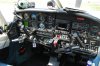
As some of you may have gathered I upgraded my panel with a Garmin 430W. This replaces my King KX155 and KLN90B. Which, from the weight of the gear, feels like I pulled about 15lbs of stuff out of the plane.

I have been out of the country for two weeks while the work was being completed and today was the day to pick up the plane. The panel looks great!!

So this morning I pulled the plane out of the maintenance hangar and fired it up. I had been reading the manual and playing with the simulator to get used to the Garmin unit. This is the 4th panel, IFR certified, GPS I have played with. The other three were all from the King series and I had gotten used to them. I set a few things up on the GPS display that I had wanted. With the data tags on I was one piece of data short than what I was used to with the King. On my 90B on the big Nav page (Nav5) I would see DTK, TRK, waypoint, distance, and ground speed. The Garmin has only room for 4 items instead of 5. So one would have to be left off.

I did change the default from North up to Track up. That is what I am used to and is my preference. If you like North up great. But I don't.

After a couple of radio checks and verification of receiving the VORs everything seemed to be working so time to fly.

Today is CAVU and the winds started off light and then were supposed to get up to 20kts. No big deal at all.

Off I went into the wild blue yonder.

I started by entering a direct to course and then verified that my AP was still functional. First checking that heading only worked and then to following the dreaded MLOD!!! Da Da Dummmm! So with that seemingly functional I punched in the RNAV26 approach into 3CK. I flew it switching to coupled and uncoulpled. The vertical guidance, like an ILS, was really neat to see in action!!!

I landed and taxied around to take off again. This time to my home airport, 10C

Once airborne I entered the RNAV(GPS-B ) approach into the unit with an IAF on the southern part of the T. No problem flying the approach but I never got an any vertical guidance. Indeed the display stated that I would only get LNAV.

This raises the question of how can I tell from the plates which approaches will get vertical guidance? The RNAV26 into 3CK is as aligned with the runway as the RNAV(GPS-B ) is to the runway at 10C. Now the VOR-A into 10C does bring you in at about a 20 degree angle. The Bravo approach is NOT an overlay. So if anyone can tell me that would be great. ITMT I will be looking for the answer.

But I digress

I flew the approach and then the missed procedure into the hold. OBS worked great and it is so easy flying a hold with the 430!!!! WOW piece of cake. I flew the course a few times and then rest of the procedure to land.

Once on the ground I did then go and update the database and then verified the new one was loaded correctly. It was a ton of fun. Too bad none of the approaches count as I was solo and NOT under a view limiting device. The purpose of the flight was to verify the gear not the pilot's competence to fly under the hood.

I do need to hit the books to get the airspace to show up. I never saw any of the Class B rings from ORD. I must need to set some sort of display option.

But all in all a cool box!!
 
very nice scott.

i've got a little WAAS GPS experience in the 430 and 480. I've never flown a GPS approach that didn't give vertical guidance. Doesn't mean they aren't out there.
 
Hmm, works at 3CK does not work at 10C, plus I think some approaches have to have a LNAV/VNAV procedure.
We were discussing what the rules are for a GPS to be a -A or -B approach as opposed to a numbered approach coming back from Wings to 1C5 on Sunday, but didn't reach a conclusion. I wonder if the problem you're seeing, though, is that you won't get vertical guidance unless it actually is a numbered approach?
 
smigaldi said:
This raises the question of how can I tell from the plates which approaches will get vertical guidance?
There are several different kinds of GPS approaches. I'll sum it up for you. I know this mostly because I researched the hell out of it when I got my instrument rating late last year.

LPV (vertical guidance), which is WAAS based, providing the lowest minimums. It has a 40 meter lateral limit and permits of a MDA down to 200 feet.

LNAV/VNAV (vertical guidance), is generally WAAS based (you can do it without WAAS but you're probably going to need a FMS and a vnav alimeter), has a lateral limit of 556m and can bring you down to 350 feet ish. Sometimes you'll see a LNAV/VNAV approach with a *LOWER* MDA than the LPV approach which I understand is because of different certification missed approach requirements.

LNAV which has no vertical guidance, a lateral limit of 556m, and generally a MDA down to 400 feet (often higher).

The standard Garmin 430 is not capable nor certified to provide you with any vertical guidance. You're stuck to LNAV approaches.

The Garmin 430W can fly LNAV, LNAV/VNAV and LPV approaches. You *will* receive vertical guidance on the following approaches:
LPV
LNAV/VNAV


You *MAY* receive vertical guidance on a LNAV approach. It will show up as LNAV+V on the GPS. This is essentially an advisory vertical guidance.

smigaldi said:
Once airborne I entered the RNAV(GPS-B ) approach into the unit with an IAF on the southern part of the T. No problem flying the approach but I never got an any vertical guidance. Indeed the display stated that I would only get LNAV.
You did not receive vertical guidance because it is a GPS-B approach with no specific runway number. This is generally because it is not aligned within 30 degrees of the runway. In this case, it is aligned, and I suspect you'll see it change to a different type of GPS approach in the future.

You *DID* get vertical gudiance (in the form of LNAV+V) on the RNAV (GPS) RWY 26 approach *BECAUSE* it has a runway number and an advisory glideslope.

Remember, LNAV+V flies like a non-precesion approach with an advisory glideslope for reference. LNAV/VNAV and LPV both fly more like an ILS.
smigaldi said:
This raises the question of how can I tell from the plates which approaches will get vertical guidance?
I think..I answered this with the above. But, count on a vertical guidance with a LPV and LNAV/VNAV approach. Expect that you *MAY* get it on a LNAV approach as LNAV+V.

If you look at the NACO approach chart you'll see that the 10C approach only has a "Circling" minimum and the 3CK approach has a LNAV minimum. The RNAV(GPS)-B is not to a runway (on paper..in real life it is), has a circling minimum, and will not have a LNAV+V advisory glideslope.
 
Last edited:
You *MAY* receive vertical guidance on a LNAV approach. It will show up as LNAV+V on the GPS. This is essentially an advisory vertical guidance.
I know the types of GPS approaches, that was not my question. The GPS26 approach only had a LNAV minimum so the VNAV was a bonus as you mentioned. But from what I can tell on the plate there is nothing to indicate when you will get such a bonus. I was wondering if there was a way to figure it out before you get on the final approach course and see the indicator.

As an FYI the GPS-B into 10C only has circling minimums. Why this directly aligned with the runway approach is NOT the GPS-27 I don't know. It may be as simple as the FAA has never certified the approach to be as accurate to get that designation. But with 500AGL minimum it is pretty good for most IFR around here. The only time I flew it and the winds favored runway 09 they were light (<5kts) so I just landed with the tail wind instead of risking a night circling approach with ceiling at 800 AGL. 10C has no approaches to runway 09.


Remember, LNAV+V flies like a non-precesion approach with an advisory glideslope for reference. LNAV/VNAV and LPV both fly more like an ILS.
Not sure I am following what you mean. While the minimums may be different between those two, the FAA has said they are both non-precision approaches. Are you saying that something on CDI will look different? I have not seen that in anything I have read so far.
 
Last edited:
I know the types of GPS approaches, that was not my question. The GPS26 approach only had a LNAV minimum so the VNAV was a bonus as you mentioned. But from what I can tell on the plate there is nothing to indicate when you will get such a bonus.
Process of elimination. You're not going to get an advisory guidance on a GPS-B approach with circling minimums.

If it is a LNAV approach, has a published glide angle on the chart, and you're running a Garmin 430W you'll likely get LNAV+V advisory guidance. If you're running Jeppesen charts you'll see a light dashed line representing the advisory glideslope.

I'm willing to bet if you dive into how the GPS builds a LNAV+V advisory glideslope versus a published LPV glideslope you'll see two different routines. The LNAV+V likely takes the published angle from FAF and calculates it internally..Whereas for the published LPV I'm sure there are way more reference points and almost all of it is coming out of the database.

smigaldi said:
As an FYI the GPS-B into 10C only has circling minimums.
Realize that, I pointed that out above on my first post, as an indicator and reason for no LNAV+V.

jesse said:
Remember, LNAV+V flies like a non-precesion approach with an advisory glideslope for reference. LNAV/VNAV and LPV both fly more like an ILS.
smigaldi said:
Not sur eI am following what you mean. While the minimums may be different between those two, the FAA has said they are both non-precision approaches. Are you saying that something on CDI will look different? I have not seen that in anything I have read so far.

The LNAV+V is an advisory glide slope. You can drop your ass below the glide slope and be just fine provided you're above the minimum for that segment (like a non-precision VOR). The LPV flies like a precision approach (call it whatever you want) with a published glide slope you follow in. The glideslope is an absolute reference and one should go missed if they drop themselves way below it. Look at the charts the LPV is setup like an ILS with an intercept altitude.
 
Last edited:
Process of elimination. You're not going to get an advisory guidance on a GPS-B approach with circling minimums.

If it is a LNAV approach, has a published glide angle on the chart, and you're running a Garmin 430W you'll likely get LNAV+V advisory guidance. If you're running Jeppesen charts you'll see a light dashed line representing the advisory glideslope.
Good to know, I am using NACO charts these days. I could not see anything on there to give and indication.

I'm willing to bet if you dive into how the GPS builds a LNAV+V advisory glideslope versus a published LPV glideslope you'll see two different routines. The LNAV+V likely takes the published angle from FAF and calculates it internally..Whereas for the published LPV I'm sure there are way more reference points and almost all of it is coming out of the database.
Yah that does seem resonable and is probably how they do it.

The LNAV+V is an advisory glide slope. You can drop your ass below the glide slope and be just fine provided you're above the minimum for that segment (like a non-precision VOR). The LPV flies like a precision approach (call it whatever you want) with a published glide slope you follow in. The glideslope is an absolute reference and one should go missed if they drop themselves way below it. Look at the charts the LPV is setup like an ILS with an intercept altitude.
I see what you meant now. Thanks.

There are times on a GPS approach were I do want to get to the mins as fast as I can so I can start looking for the runway. As you say the LNAV+V will allow me to do just that.
 
WRT to showing the class Bravo rings:
press "CLR" to add/subtract the amount of data the screen displays.
 
WRT to showing the class Bravo rings:
press "CLR" to add/subtract the amount of data the screen displays.
I was up flying some more approaches and playing with the gps today. I got the display to show the rings of bravo. I was just zoomed in too much. I also noticed how when it goes into approach mode it takes away some clutter automatically and gives an indication that it has done so.

I finished all the testing today. My DME is slaved to the unit so that I do nto have to seperately put in the frequency into the DME and I can select which nav is feeding the DME. That all worked correctly. I needed to check NAV 1 VOR APO tracking and that was good. Lastly I wanted to fly a few approaches where the GPS was jsut an advisory mode unit such as an ILS and that all checked out perfectly too.

So basically the unit is installed and everythign works and is aligned without having to go back to the shop to have them tweak something!!! On a complicated install that is a really nice out come.
 
Same being installed now. I hope it can find Arkansas.

Here is a pic of the old panel with the KLN90B and 2-KX155's. Then there is the new panel with the 430W in it.
 
Here is a pic of the old panel with the KLN90B and 2-KX155's. Then there is the new panel with the 430W in it.

Nice. Although by the space left above the audio, clearly you had room for a 530! :D

I see you were able to get rid of the annunciator/pushbuttons too. Couldn't find Waldo, though.
 
Nice. Although by the space left above the audio, clearly you had room for a 530! :D
I did think about it, but the price differential made no sense. Longer term I am going to move the DME to the left, most likely remove the ADF and then add in a mount for a 496 to get WX

I see you were able to get rid of the annunciator/pushbuttons too.
yep
 
Here is a pic of the old panel with the KLN90B and 2-KX155's. Then there is the new panel with the 430W in it.

<drool></drool>

They swapped your transponder/DME head position, too... was that random, or for a reason?
 
<drool></drool>

They swapped your transponder/DME head position, too... was that random, or for a reason?

Doesn't the DME connect to the NAV radios to auto-channelize? Perhaps the existing wiring couldn't reach the 430 like it did the previous KX155 and had to be moved up and closer.

:dunno:
 
Doesn't the DME connect to the NAV radios to auto-channelize? Perhaps the existing wiring couldn't reach the 430 like it did the previous KX155 and had to be moved up and closer.

:dunno:
The DME is connected to both radios and the autotune is selected by a switch on the panel.

They were cleaning up some wiring issues and it looks like they not only swapped the transponder but also moved it down so the two stacks were in near height alignment with each other.
 
Oh and I got the bill for all the work yesterday. It came out right on budget. The cleaning up of the wiring added a few hours and actually solved another minor nit I had been having. The unit and install came to just a tad over $10k
 
Scott
If you're going to throw out that old KX-155, maybe throw it my way:D
What would you want for it?
 
He has it tuned to WGN. Don't kid yourself. He was listening to Judy and Judy, the radio sisters.

If I flew in the Chicago area, I'd tune it to 780 so I could listen to traffic and weather together on the 8's, look at all the poor suckers on the ground, and laugh hysterically. :yes:
 
Back
Top