dell30rb
Final Approach
Checking the weather yesterday, and early this morning showed an excellent forecast for the weekend. I would have loved a little stratus to use the instrument rating, and it looked like I might have some on sunday, but overall it was looking like good VFR. Not so! My, how the forecast has changed...
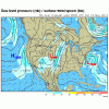
The flight is from KTTA (raleigh) to KECG (elizabeth city) on friday afternoon, I should get there at sunset, allowing for some headwinds. About a 1.5 hour flight. I will be departing with about 3.5hrs fuel. The current forecast has a north east wind around 15-25kts friday evening, rain/tshowers. The prog charts show a low pressure system developing off the coast, i'll be flying into an area approximately north west of the low, which will be dumping all kinds of moisture from the Atlantic into the vicinity.
The forecasts are calling for showers and wind friday afternoon/evening. The chance of showers on weather.com is 30%, so that looks good. Saturday is more showers and less wind. A TAF forecast discussion mentions MVFR ceilings friday night.
My big concern is that there may be turbulence with all of this junk going on. There looks to be a low probability of convection, and I don't see anything indicating a lot of shear, i'm not flying through a front or anything. I have a full plane for this trip, passengers can handle a little mechanical turbulence at the end of the flight and the jockeying around that comes with a gusty wind on landing, but I don't want to bounce them off the ceiling for an hour on the way down there.
I have 50 hrs in the airplane in the last year (Warrior II) and 7 of those are simulated instrument. I have 10hrs of actual since mid march, but none of those are in the warrior.
Anyway I'm nowhere making my decision yet, experience has taught me to wait until the last possible moment because as we all know, the forecast is just a forecast. But i'm going to be scouring the forecasts anyway, though i know it is futile.
Attachments
Last edited:

