Glacier Park from the East?

airdale

Pattern Altitude
Joined
Dec 30, 2007
Messages
1,840
Display Name

Display name:
airdale
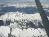
My wife and I will be visiting Glacier Park in August. I am basically a midwestern flatlander, with some mountain (8000 MEAs) flying in Canada and some mountain flying in NZ. Lots of cross-country (130+ airports last time I counted), Commercial/Instrument rated. We'll be in an Arrow, well below max gross and with 72 gallon tanks.

Looking at the exciting MEAs between eastern Montana and Kalispell/Glacier, my baseline plan was to park the airplane at Cut Bank, then rent a car.

But after spending time with Google Maps and some sectionals, it looks to me that there might be a decent route via Great Falls, MT then roughly following the highway to Missoula, and north up the valley to Glacier International. For the last leg, there is also another valley to the East, following MT hiway 83, that looks like an option. I would only do this VFR. Not IFR.

Anybody familiar with the area care to offer comments or suggestions?
 
Why not just follow US Hwy 2 westbound from Cut Bank through Marias Pass to Kalispell? It's the route of the Great Northern Railway, the lowest crossing of the Divide north of New Mexico, and a spectacular trip. Very doable VFR westbound at 10,500' MSL.

East Glacier and the Glacier Park Lodge are in the first photo; the last is the Flathead Valley approaching KGPI.

Mvc-728s.jpg


Mvc-730s.jpg


Mvc-731s.jpg


Mvc-739s.jpg
 
Yeah, you ought to be fine in august (Ocassional T-Storm but usually small and very short lived and almost always happen in the early evening/afternoon) to go VFR and just follow Marias pass through. If the cumulogranite scares you, you can go D-> from KMSO at 6500', which is why I frequent the area so much, it's the only direction I can go VFR without CAVU days. When i go to Cut Bank I go via the Higway 200 route, that's also the way I go to Calgary instead of trying to go direct over the mountains that are concerning you, going via Missoula will be out of the way quite a bit. Oh and go out the east entrance of Glacier park, hang a left into Babb Montana (about 6 miles or so) and eat at the Cattle Baron Supper Club, bring an appetite, PETA members need not apply.
 
Go high, go direct those rocks aren't that high.
taken from a 170
 

Attachments

  • P1010019.JPG
    P1010019.JPG
    707.2 KB · Views: 29
Last edited:
Ok, I am going.
Me too. :)

Thanks, gents. I'll cancel the Cut Bank plan and plan to go to Glacier International by one of those two routes. The responses were exactly what I was looking for.
 
Me too. :)

Thanks, gents. I'll cancel the Cut Bank plan and plan to go to Glacier International by one of those two routes. The responses were exactly what I was looking for.

What ever route you take, do not follow the RR tracks across, they do go thru the mountain.
 
Last edited:
Me too. :)

Thanks, gents. I'll cancel the Cut Bank plan and plan to go to Glacier International by one of those two routes. The responses were exactly what I was looking for.

KGPI is closer to the park, I always go to S27. No instrument procedures but you might save a buck.
 
do not follow the RR tracks
Well, I suppose setting down on a boxcar going at Vso might work but the 35' wingspan might be a problem.
 
Last edited:
KGPI ain't bad but S27 is more homey.

Yip, S27 is on the south edge of town and right beside a grocery store, so if you need supplies before you head into the park, it might be as good of an option, I don't recall ever paying any ramp fees and the folks at Red Eagle are good folks. They can get you a car too. There's also a raving lunatic trying to shut the airport (S27) down making all sorts of wild claims and putting on a scare tactic campaign (Claims methane from a nearby sewage treatment plant causes airplane engines to quit among other things), The airport could use the support.
 
Why not just follow US Hwy 2 westbound from Cut Bank through Marias Pass to Kalispell? It's the route of the Great Northern Railway, the lowest crossing of the Divide north of New Mexico, and a spectacular trip. Very doable VFR westbound at 10,500' MSL.

East Glacier and the Glacier Park Lodge are in the first photo; the last is the Flathead Valley approaching KGPI.

Mvc-728s.jpg


Mvc-730s.jpg


Mvc-731s.jpg


Mvc-739s.jpg


Now wait just one minute.......

That cowling, wingtip, and view look eerily familiar.

Hey, that's my Tiger over the Rockies! BTDT. WTF? Everyone knows Tiger are terrible out west, especially in the mountains. What gives?


:D
 
Now wait just one minute.......

That cowling, wingtip, and view look eerily familiar.

Hey, that's my Tiger over the Rockies! BTDT. WTF? Everyone knows Tiger are terrible out west, especially in the mountains. What gives?
:D

Just think,,, high over the Rockies with out a turbo charger, how crazy is that? Every body knows you can't do that. :)
 
Now wait just one minute.......

That cowling, wingtip, and view look eerily familiar.

Hey, that's my Tiger over the Rockies! BTDT. WTF? Everyone knows Tiger are terrible out west, especially in the mountains. What gives?
What "Tiger"?? That was my Cheetah! :)

(High-compression STC, of course! :D)

That was on my trip from Flying Cloud (KFCM) near Minneapolis to Vancouver WA (KVUO), 13 hours in one day. :yesnod:
 
What "Tiger"?? That was my Cheetah! :)

(High-compression STC, of course! :D)

That was on my trip from Flying Cloud (KFCM) near Minneapolis to Vancouver WA (KVUO), 13 hours in one day. :yesnod:


You know I thought I remember you saying you had a Cheetah. A guy I knew when I lived in Denver, had an HC Cheetah based at my airport, KFTG, and flew it with his dad to Alaska and back. Said he had a blast.

13 hours is a lot of flying my friend. Did they have to pour you out of the plane? :)
 
We did it out of West Yellowstone, IIRC, with a stop in Great Falls to pick up a passenger, so there were five of us. I'll have to look up the route we took when I get home. It was in a normally aspirated twin (310), so adequate power, but still need to be respectful of cumulus granitus!
 
What ever route you take, do not follow the RR tracks across, they do go thru the mountain.
Looking at the chart, he ought to see Hungry Horse Reservior and head to the airport before the tracks go through the mountain.
 
We did it out of West Yellowstone, IIRC, with a stop in Great Falls to pick up a passenger, so there were five of us. I'll have to look up the route we took when I get home. It was in a normally aspirated twin (310), so adequate power, but still need to be respectful of cumulus granitus!
Well, I looked and I just don't remember the route we took. I don't think I was piloting that leg. I do remember asking the chief pilot when we were sitting in Custer what his plans were for the flight, because Leslie and I had charted out an entire route based on the 172 we expected to be flying, and he said "I plan not to hit anything!":wink2:

That said, there's a V536 that goes directly between Kalispell and Great Falls with a minimum safe altitude of 11,400. Doable VFR.

Go IFR (I Follow Roads). just follow the pass through. Those mountains are pretty unforgiving should any sort of issue occur and I've lost altitude in the blink of an eye, those winds can either be free lift or a free landing during the summer. Sticking near the roads at a nice high altitude and cutting through the mountains via passes is the best option. Pretty much everything east of Kalispell is either national park or wilderness, I do fly over the Bob and Big Bear from time to time, but sticking to the roads is the best bet. The Mountains aren't Alaska or Colorado high and I go over em in a 150HP cherokee but for less pucker factor, just to from KCTB to Kalispell via highway 2. North and south of you will be some of the most rugged country in the lower 48 and Highway 2 is the Only thing in the area that isn't protected land (i.e. nobody and no roads forestry service or otherwise for miles). If you want to cut through the mountains and see Montana, go to 3U7 should be on every pilots bucket list.
 
Last edited:
Back
Top