There are many unplanned circumstances, in which terrain warning would have been life saving beneficial. I have many "for instance", accident storys I could discuss, but here is one....
Pilot is on a multi state cross country with his twin engine aircaft. The winds have been unfavorable & will require an unplanned fuel stop. He is flying parallel to a mountain range and starts a descent to an untowered airport. Since it's a bit hazy & the ground is covered with snow, he has no idea that within a few seconds, quickly rising terrain will appear that's several hundred feet higher than he is. At the last second, he slams both throttles full forward, and yanks full back on the yoke. It's the only option. The aircraft stalls into the terrain at nearly the same angle, and cartwheels. He's very lucky, as he and his wife suffer only minor cuts and bruises. In the meantime, residents in homes a few hundred feet below, worry that the airplane will slide down into their homes. This ridge is a steep one. And it's also an illusion. When seen from certain angles, and especially in haze, it doeasn't appear to suddenly rise from level ground. It's ninty degrees to terrain that's several thousand feet higher. BTW--- this same area has been clobbered in various angles over the years.
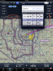
As I do live out here, and have known many, many CFIT accidents over the years............terrain database GPS can be the "wonderful" difference between being here now........and gone in a second.
L.Adamson