Forecasting tops

mikegreen

Pre-takeoff checklist
Joined
Jan 28, 2010
Messages
201
Location
Denver
Display Name

Display name:
mike g.
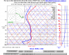
Attached is todays 12z sounding forecast+24hrs for JOT (8am local tmrw).

I'm new to this type of display, and the clouds in general :) I can see where the dewpoint spread closes and that corresponds with the scattered 5000 ovc 7000 forecast...

But what about tops? Is there any published tops forecasts? Or does this really indicate I'd be in the clouds 7k and up??

I'd ask my CFII, but he's on vacation..

regards,

Mike
 

Attachments

  • 2013-01-17_1041.png
    2013-01-17_1041.png
    68.9 KB · Views: 54
there are no clear cut tops from the forecast. but there is also a little bit of spread so you might find that you'll be in and out of clouds depending on if the area your in is a little moister/dryer or warmer/cooler than that point forecast.
 
Looks like I need to practice reading RUCs. 7-27k looks like IMC conditions.
Gonna monitor this thread.
 
oh sometimes you'll see a tops forecast in the area forecast. otherwise the sounding and PIREPs are your best bet. i see you are in dayton so if i was you i wouldn't be afraid to call up the tower and ask what they are getting for tops reports, if any, if i was curious.
 
I noticed you used the GFS model. I read somewhere the Op40 model was the way to go, though I am not really sure why. Also I wouldn't expect it to be that accurate more than 12 hours out anyway. (you are making this flight 8am tomorrow, correct)

The area forecast does not include tops in the outlook forecast to my knowledge. Just in the immediate forecast period. So check the area forecast tonight and you might see some info on the tops tomorrow.
 
I thought the most reliable method of forecasting cloud tops was to take the service ceiling of the aircraft you're flying and adding 2,000' to it.
:dunno:
 
I have never used this method and might be misremembering the details, but I believe that another way that has been mentioned is to tweak the temp-dewpt divergence on the sounding by using cloud top temps as derived from color-coded IR satellite images.
 
I thought the most reliable method of forecasting cloud tops was to take the service ceiling of the aircraft you're flying and adding 2,000' to it.
:dunno:

:rofl: ain't that the truth. kinda like knowing the wind will be blowing 180 degree opposite of what you're flying.
 
Mike,

Your CFI wouldn't know anyway...

Based on this GFS sounding, it's hard to get a good read on where the tops are located. The GFS moisture in the lower troposphere isn't all that good in these kinds of circumstances - so I wouldn't trust it. If you use a higher resolution model such as the RUC (below), you'll see two potential cloud layers at 5,000 and 11,000 feet.

JOT-Forecast-Sounding.gif

... and at levels that are about -8C. My bug smasher can't climb like a rocket so I wouldn't try to get on top in these conditions.
 
Well they're way up there, asusming JOT is in the blue zone. -50 on the Skew T would put them at about 24,000 feet.

What scott says is true but note that both layers are between -10 and Zero, and you'll get ice.

This is a day for a FIKI ship capable of rapid climb to the really really cold layers.
 

Attachments

  • JOT1440SAT.temp.doc
    974 KB · Views: 9
Thanks guys. This is helpful.

Scott - OP40 or RUC? Anyone know of a site that explains the pro/cons?
Do you have a webinar on those? Or is any skew-t the same reading?
Before my membership lapsed I did the basic ones - stopped the hardcode weather learning to focus on my IFR ticket (which, checkride was canceled today due to examiner being sick :-( ).

Bruce - I never look at the IR images... But found this off the page you showed..
http://aviationweather.gov/adds/satellite/displaysat?region=US&isingle=single&itype=ir

and http://aviationweather.gov/adds/satellite/description/page_no/2

The Infrared (IR) channel is calibrated to temperature and expressed in degrees Celcius. Where clouds exist, the temperature is that of the tops of clouds. Where clouds do not exist, the temperature is that of the ground or the ocean. This information could be very valuable to aviators since clouds with tops below 0°C, may indicate that an Icing hazard exists. [An icing hazard could also exist in clouds warmer than freezing particularly if there is a strong temperature inversion beneath the cloud.]

regards,
Mike
 
Back
Top