terzap
Line Up and Wait
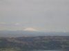
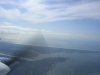
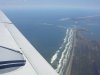
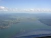
Since my sister (the motorcycle racer) decided to come along with me on my lesson this morning, my instructor suggested she could pick our destination for the day. So instead of going to HIO to shoot touch and goes (which can be exciting for passengers who like near death experiences ") ) we flew West to Tillamook, over the bay, and turned north up the coast. It was an exquisite day and the only problem was: left the camera at home!
) we flew West to Tillamook, over the bay, and turned north up the coast. It was an exquisite day and the only problem was: left the camera at home!
Laura could not believe it was real--flying over the Coast Range and then to the ocean--in less than twenty minutes compared to an hour and forty five minutes via the roads! She was totally thrilled with the entire flight. So was my instructor. It was a nice Sunday morning jaunt and I just got to sit back, concentrate on my course and altitude and enjoy myself, too. We saw schooling fish and Laura spotted a pod of dolphins herding some salmon into a group for an early lunch. I looked hopefully for some orcas, but it is a little too early to see them, I was told.
The Oregon coast is just beautiful and I wish we had pics to share with all of you. It was the first time I flew over (withing sight of the beach) an ocean or other huge body of water, unless you count Lake of the Woods in Minnesota, which was frozen solid enough to land on, or miles and miles and miles of the flooded fields of the Red River Valley earlier this year.
Anyway, it was great, and can't wait until I don't need to have an instructor along to do another flight like this.
terry
) we flew West to Tillamook, over the bay, and turned north up the coast. It was an exquisite day and the only problem was: left the camera at home!Laura could not believe it was real--flying over the Coast Range and then to the ocean--in less than twenty minutes compared to an hour and forty five minutes via the roads! She was totally thrilled with the entire flight. So was my instructor. It was a nice Sunday morning jaunt and I just got to sit back, concentrate on my course and altitude and enjoy myself, too. We saw schooling fish and Laura spotted a pod of dolphins herding some salmon into a group for an early lunch. I looked hopefully for some orcas, but it is a little too early to see them, I was told.
The Oregon coast is just beautiful and I wish we had pics to share with all of you. It was the first time I flew over (withing sight of the beach) an ocean or other huge body of water, unless you count Lake of the Woods in Minnesota, which was frozen solid enough to land on, or miles and miles and miles of the flooded fields of the Red River Valley earlier this year.
Anyway, it was great, and can't wait until I don't need to have an instructor along to do another flight like this.
terry
Last edited: