olasek
Pattern Altitude
Does anybody know example of a DME station not co-located with a VOR or LOC? Apparently in Europe they show up once in a while but I was wondering how it is in US?
Last edited:
How would you use a dme without some sort of azimuth indicator? It seems to define a circle not a position.
I'm wondering, not suggesting it's not being done.
Joe
Actually many older FMS units prefer to use DME-DME for position fixing (triangulation) over VOR-DME or VOR-VOR. DME-DME gives you the least computational error - of course GPS is even better but some old FMS are not yet GPS capable.How would you use a dme without some sort of azimuth indicator?
Yes, but TUS is a VOR-DME here, isn't it? I am looking for a DME not co-located with VOR or LOC.Here's an NDB/DME approach but the NDB and the DME are in two separate locations.
http://204.108.4.16/d-tpp/0910/06513NDG6R.PDF
Does anybody know example of a DME station not co-located with a VOR or LOC? Apparently in Europe they show up once in a while but I was wondering how it is in US?
Actually many older FMS units prefer to use DME-DME for position fixing (triangulation)
Does anybody know example of a DME station not co-located with a VOR or LOC? Apparently in Europe they show up once in a while but I was wondering how it is in US?
You can do so; remember, DME simply shows the distance (slant range) to the DME station. They are almost always colocated with a VOR, LOC or TACAN, but are nonetheless a separate device.
One challenge of using a DME which is not colo'd with a VOR or LOC is figuring out how to tune it, and for that, you need to use a DME channeling table. I knew a guy (strange one) who flew to Canada, and we looked all this up because certain of his destinations had NDB/DME approaches. So, you see what the DME's channel is (on the plate), and tune the DME (or, its associated NAV radio) to the matching VOR/LOC frequency which, even though you are not even receiving a VOR/LOC signal, nonetheless pairs the DME to the right channel.
Yes, but TUS is a VOR-DME here, isn't it?
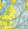
There's one at MSP that's not co-located with either a VOR or an NDB. It's used for the approaches to 12R/30L and to define the Minneapolis Class B:
Actually many older FMS units prefer to use DME-DME for position fixing (triangulation) over VOR-DME or VOR-VOR. DME-DME gives you the least computational error - of course GPS is even better but some old FMS are not yet GPS capable.
That's technically not triangulation, as triangulation is azimuth-azimuth (bearing-bearing) fixing, and not distance-distance fixing.
Halloween carryover?I don't think you can do DME-DME without some sort of INS, as the unit has to know witch of the 2 possible solutions to throw out. 1 DME gets you anywhere on a circle, 2 DMEs gets you on the two points where the circles intersect.
I-HKZ is the RWY 12R ILS/DME, the RWY 30L ILS/DME is I-MSP. Different localizers, same DME. Interesting that I-HKZ has the restriction, "DME unusable beyond 25 degrees right of course" while I-MSP has no restrictions and I-HKZ DME defines the Class B airspace.
For a long time the DME upon which the Minneapolis Class B was defined was co-located with one of the ILS antennas at the MSP airport. Several years ago they relocated the MSP VOR from a point about 16 nm NW of KMSP to the north side of the airport property and at that time the DME was relocated to the same spot.
A third DME would also do, but I don't know which of the two methods FMS's use.I don't think you can do DME-DME without some sort of INS,
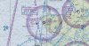
Interestingly (at least to meThe following NDB-DMEs are not co-located with a VOR or LOC
Minnesota
ULM
") ) I shot those NDB approaches hundreds of times, but I haven't had the opportunity to fly them since they added the DME.
) I shot those NDB approaches hundreds of times, but I haven't had the opportunity to fly them since they added the DME.As an aside, what is inherent in your solution, but unstated, is that it requires altitude as an additional input into the solution.That's technically not triangulation, as triangulation is azimuth-azimuth (bearing-bearing) fixing, and not distance-distance fixing.
I don't think you can do DME-DME without some sort of INS, as the unit has to know witch of the 2 possible solutions to throw out. 1 DME gets you anywhere on a circle, 2 DMEs gets you on the two points where the circles intersect. DME-DME is probably used to reduce the error bars on the INS Kalman Filter.
--Carlos V.
With a bit of logic you can throw out one of the solutions. Wait ten minutes or so and take the distances from the two DME sources again. You now have two displacements, since you know what your heading was one of them can be eliminated.
Does anybody know example of a DME station not co-located with a VOR or LOC? Apparently in Europe they show up once in a while but I was wondering how it is in US?