Crossing the Sierra Nevada, SFO->LAS

mtuomi

En-Route
Joined
Sep 6, 2013
Messages
3,056
Location
Dallas, TX
Display Name

Display name:
dera
Hey Y'all, I'm planning a trip from the SFO area to Las Vegas, late February/Early March. VFR.
Does anyone have any PIREPs about crossing the mountains during that time of the year?

3 people, PA28-180 or similar (yet to be confirmed...), I was looking at flying PAO-Friant-Mammoth, then down the Owens River, then over to KVGT.

Happy to hear any suggestions!
 
PA28?

Unless it's turbocharged, go around the Sierra. Tehachapi works. Direct LAS puts you right over Mt. Whitney.

Archers suck over 10,000. And Mammoth Pass is higher than that.

The Sierra you're talking about crossing is VERY remote in winter. There are no roads through there, and rescue is probably not coming for a while if you have a problem. Have a dang good survival kit, and dress for the ground. That is, snow survival equipment on you at all times. Otherwise, even a benign engine failure with a perfect landing is a death sentence. You will not get flight following west of the pass, and no one has you on radar. If your ELT doesn't go off or gets consumed by fire (and that's common), you die.

I wouldn't do that in winter. Summer, perhaps. But in a better airplane. Even a 172RG is substantially better. And even then, I'd want to fly over Tioga Pass and only when the road is open.

Flying over Tahoe is much better, as the roads are open in winter and the terrain is 3000 feet lower. But it's far north of your track.
 
I'm with MAKG... don't attempt it in that aircraft with that load. That's turbo country.

I flew an Archer II from KAPC to KLAS years ago. Route was down the Central Valley, over Tehachapi, then Palmdale, Victorville and along I-15 up to Vegas.
 
It is not reasonable to subject your pax to the proposed route at that time of year. KPAO-TTE-KVGT is a safer bet. If not GPS equipped do not even try to thread the R-airspace. Coordinate with Joshua APP. Contact the using agency at China Lake. Review the AF/D and use the landline to contact prior to flight.

It is possible for VFR traffic to be cleared through R- but the pilot should also be aware of the specific complexities of R-2505, R-2506, R-2524, including an uncharted CFA.

If not cleared through R-, TTE VOR then north of the SUA then direct KVGT is my suggestion. Make east then hang a left to go north when just west of Highway 395.

As has been mentioned, the area of the proposed crossing of the Sierra is the highest elev. and very rugged.
 
I'm with MAKG... don't attempt it in that aircraft with that load. That's turbo country.

I flew an Archer II from KAPC to KLAS years ago. Route was down the Central Valley, over Tehachapi, then Palmdale, Victorville and along I-15 up to Vegas.

Second the motion. Tehachapi pass is very wide and has an airport at the top of it. Rest of the route is pretty benign also.

Don't even THINK about going across the Sierra to Mammoth in winter. Unless you are a candidate for the Darwin Award.

Jim
 
Hey Y'all, I'm planning a trip from the SFO area to Las Vegas, late February/Early March. VFR.
Does anyone have any PIREPs about crossing the mountains during that time of the year?

3 people, PA28-180 or similar (yet to be confirmed...), I was looking at flying PAO-Friant-Mammoth, then down the Owens River, then over to KVGT.

Happy to hear any suggestions!

I've been doing that route for decades. First in a 180hp STCd 172, later in 180hp Cherokee, currently in a Flight Design CTSW.

Going to Friant is the conservative approach keeping you over low terrain and generally providing smooth winds. Follow V230 till Mammoth Mountain and then turn to KMMH, then in about 10 miles turn to 120 degrees to cross between the Whites and Inyos at Black Mountain. From Their its direct with a corner of 1 restricted area to stear around.

The Cherokee was slow but had little trouble with the altitude, lowest possible crossing is 9,600, most feel comfortable at 11,500 and even 10,500 going back.

Fuel in Mammoth is expensive but Bishop means a big climb over the Whites/Inyos.

Awesome route I highly recommend it.
 
late February/Early March can be excellent, worth a call if you intend to land Mammoth to check on runway, taxi-way and ramp conditions. Most likely will be clear but potential for a lot of snow or even ice exists.

If a storm is coming through your probably don't want to go over or around.

Late March/April is when the big winds begin. You probably don't want this route if winds at 10,000' are high. Notice how V230 lines up with the prevailing SW wind? On a windy day it often provides a smooth ride with a bit of a rotor to penetrate on the short descent.

You probably don't want this route if ceilings are below 14,000' it can be hard to remain VFR.
 
If winds are calm you can take a scenic short cut. Fly direct to Yosemite Valley, a slow climb to get you their at ~10,000 works great for view. If you don't have good climb performance at that point this is a bad route.

From Yosemite Valley turn towards Mammoth, approach V230 on the south side of the peak marked 1135 . This is the way I go if its smooth, you can fly whatever agl altitude you are comfortable at or just use 11,500. As soon as you go to and east side altimeter you will be much higher.
 
I've been doing that route for decades.


I wouldn't doubt it. If I lived in Mammoth like you do, I'd probably have the same feelings and have done it dozens of times.

WE have a fellow here coming out from NY City to San Fran and flying an unfamiliar airplane to Vegas. I still say the southern route around the end of the Sierra is the preferred route for him.

Jim
 
I didn't notice that the OP is from NYC so I will throw in the importance of leaning for best power at take off from Mammoth.

We all have our points of view, personally I can't see going that far out of my way to avoid all the best scenery.

Stopping in Death Valley is convenient on this route too.

And taking winds seriously.

Crossing a high mountain pass is a multiplier. And flying east of the crest sometimes has rotors and other nasty turbulence. You are vulnerable even at low altitude, but it's a whole lot worse at 12000 when that 180 will barely wheeze up to 200 FPM.

Even crossing Tehachapi on a windy day can be challenging. You have to know where the wind is, and especially where it's rising.

There is no such thing as IFR over the Sierra in a naturally aspirated non-FIKI airplane, so if the weather is normal for February, there might be a problem. In summer, the risk is thunderstorms. In winter, it's ice.

Owens Valley is notorious for turbulence. I recommend flying as early as possible through there. And consider a no-go for wind if it's more than about 20-25 knots aloft at 12000 at Bishop (BIH).

The scenery is fabulous beyond description, but it's very important to understand and assess the risks. They are significantly more than a weekend jaunt down Long Island.
 
Last edited:
If you can, a 182 or a 235 cherokee, or a mooney, or a Bo, ... 1 little step up would mean a lot. Even if you go around the Sierra Las Vegas is prone to the same issues, high DA, rapidly rising terrain, ...etc. especially for 3 people, how big are they, do they bring luggage?

What you propose is quite doable, extra margin is good too.
 
I fly out of Tracy (KTCY) and a fly to north Las Vegas is on my bucket list. However, when i preplan for the flight, i'm hesitant to turn left at Bakersfield and fly through all those Restricted areas. Have any of you? Does Flight Following grant you access through those areas regularly?
 
Owens Valley and coming up on the east side of the Sierras can be no joke either. That's the place I've had the worst turbulence/rotors ever.
 
Have you considered Frontier or Southwest?
 
If the restricted zones are hot, an option is to fly over Palmdale, and follow I-15 to Vegas. Dodges everything.
 
Owens Valley and coming up on the east side of the Sierras can be no joke either. That's the place I've had the worst turbulence/rotors ever.

The proposed route bypasses the Owens Valley. Just cross over to Deep Springs at Black Mtn and then over to Eureka Valley.
 
Fly south to a lower pass, then turn east.

standard mountain flying, go somewhere the rocks aren't and don't be shy about following roads and never but never fly up a valley (while down in the valley)

other folks have mentioned the wind rules which ya gotta honor if you want to do more than fly *into* the mountains
 
Good suggestions, thanks guys!
I've crossed the Swiss and Austrian Alps a few times, so I know the basics of mountain flying.
I wouldn't even consider flying there, if the weather was anything but severe clear.
Darwin Award is not something I'm trying to win...
Another good option looks like TTE->Kern Valley->China Lake, then either get clearance through the R-area or turn north towards Owens Lake to avoid it, then direct VGT.
That looks like at 10500 I would have comfortable clearance over terrain. Any experience with that route?
The "easy" option of course would be to route south, but it would kill me to be so close to such amazing scenery, then fly so far out of my way to avoid it...
 
Remember this, "Severe Clear" comes with the most severe winds and turbulence on that route, regardless which you pick. If you can cross the mountains downwind, you are golden as nature will work in your favor giving you lifts as you approach ridges. Crossing them into the wind is where you have to visualize where the vortices form and the eddies and reverse flows run. If you have ever watched water flow through a dam of rocks in a creek, it's the same thing.

The smartest thing to do I'd fly south along the western slope until you get to the first major crossing highway which IIRC will be the Corona pass I-15? It's been a while since I operated there, and I had a turbo twin for a reason. Follow the farm valley down and a major highway through the mountains, it will provide you a low route and some landing possibilities. Being able to stay down at higher performance altitudes longer and not spending the time climbing (although a PA-28-180 should climb fine unless at gross) may make the extra distance issue a small factor in time.

Oh yeah, always remember, if you are flying into the wind towards a ridge and the plane starts climbing, climb with it. Call ATC and tell them you are in an uncommanded climb in a wave and may exceed 180, don't worry about the altitude for the short time you'll be there, because in a couple of minutes you'll be on an express elevator down that is coming down that slope facing you. Put the nose down and go for airspeed to clear the ridge. If you put the nose down in the updraft, you won't clear the ridge.
 
Last edited:
I'm with MAKG... don't attempt it in that aircraft with that load. That's turbo country.

I flew an Archer II from KAPC to KLAS years ago. Route was down the Central Valley, over Tehachapi, then Palmdale, Victorville and along I-15 up to Vegas.

I'd recommend the same route. Once you are through the pass at Tehachapi you can check with Joushua approach and see if you can get across the MOA. Or at least follow rte to Barstow and the. Up I-15. From Baker head for Sandy Valley NV and the pass towards Good Springs, clear the south side of Potosi and you are in the LAS valley.

Watch the pass at Tehachipe and around Potosi if the winds are up.
 
Second the motion. Tehachapi pass is very wide and has an airport at the top of it. Rest of the route is pretty benign also.

Don't even THINK about going across the Sierra to Mammoth in winter. Unless you are a candidate for the Darwin Award.

Jim

What?? Unless there is weather along your route, Winter is one of the best times to cross. I do it all the time.
 
I fly out of Tracy (KTCY) and a fly to north Las Vegas is on my bucket list. However, when i preplan for the flight, i'm hesitant to turn left at Bakersfield and fly through all those Restricted areas. Have any of you? Does Flight Following grant you access through those areas regularly?

Bakersfield, Kern Valley, Inyokern, Trona Pass, VGT can work.
Depends if the the airspace is hot, talk to Joshua Approach.
Cross into LAS valley by following the highway from Pahrump to Blue Diamond, lower part of the Spring Mtn range, if it's windy there is serious rotor in Red Rock area.
 
Good suggestions, thanks guys!
I've crossed the Swiss and Austrian Alps a few times, so I know the basics of mountain flying.
I wouldn't even consider flying there, if the weather was anything but severe clear.
Darwin Award is not something I'm trying to win...
Another good option looks like TTE->Kern Valley->China Lake, then either get clearance through the R-area or turn north towards Owens Lake to avoid it, then direct VGT.
That looks like at 10500 I would have comfortable clearance over terrain. Any experience with that route?
The "easy" option of course would be to route south, but it would kill me to be so close to such amazing scenery, then fly so far out of my way to avoid it...

That route would be far enough south to miss all the good scenery.

Of course the magic way to do this crossing is on a full moon, crossing at 10,500 between the 13,000' snow covered peaks.
 
Why not route him through Mexico?


Charlie Tango, will you shut the F up for a couple of minutes? He is from New York, he is considering a PA-28-180 to go across some of the most forbidding landscape in this country. In the winter, I really don't want to be called out to pick what is left of him up with a shovel and a spoon.

He has "experience in the European alps" and such. Great. Ever gotten into a triple lenticular over the lee side of the Sierra and thrown into a rotor? I have. ANd it ain't much fun. And it ain't survivable unless you have been taught how to get out of it.

Charlie Tango, he asked how to get from SFO (which isn't going to be his airport of departure since nobody rents aircraft out of SFO) to LAS. He isn't going to go into LAS since light singles aren't welcome there.

Why don't we just give him the local best routing for his experience level and let it go at that.

THanks,

Jim
 
I wouldn't doubt it. If I lived in Mammoth like you do, I'd probably have the same feelings and have done it dozens of times.

WE have a fellow here coming out from NY City to San Fran and flying an unfamiliar airplane to Vegas. I still say the southern route around the end of the Sierra is the preferred route for him.

Jim

I did notice the OP list NYC. What you say here is exactly why I didn't provide the detail that Charlie Tango does. There are at least two routes that can be done at 9,600. CT identified one of those. But I won't give that info to a pilot unless they have a good amount of experience in mtn terrain. And until the pilot shows that he does I assume they don't have that experience.
 
Owens Valley and coming up on the east side of the Sierras can be no joke either. That's the place I've had the worst turbulence/rotors ever.

Next time try sliding a bit upwind or downwind to see if it smooths your flight. Sometimes a 1/4 mile one way or the other will be significant.
 
Remember this, "Severe Clear" comes with the most severe winds and turbulence on that route, regardless which you pick. If you can cross the mountains downwind, you are golden as nature will work in your favor giving you lifts as you approach ridges. Crossing them into the wind is where you have to visualize where the vortices form and the eddies and reverse flows run. If you have ever watched water flow through a dam of rocks in a creek, it's the same thing.

The smartest thing to do I'd fly south along the western slope until you get to the first major crossing highway which IIRC will be the Corona pass I-15? It's been a while since I operated there, and I had a turbo twin for a reason. Follow the farm valley down and a major highway through the mountains, it will provide you a low route and some landing possibilities. Being able to stay down at higher performance altitudes longer and not spending the time climbing (although a PA-28-180 should climb fine unless at gross) may make the extra distance issue a small factor in time.

Oh yeah, always remember, if you are flying into the wind towards a ridge and the plane starts climbing, climb with it. Call ATC and tell them you are in an uncommanded climb in a wave and may exceed 180, don't worry about the altitude for the short time you'll be there, because in a couple of minutes you'll be on an express elevator down that is coming down that slope facing you. Put the nose down and go for airspeed to clear the ridge. If you put the nose down in the updraft, you won't clear the ridge.
Do you mean El Cajon Pass (the western terminus of the historic Santa Fe trail) which transitions from the SoCal basin to the high desert? That's way too far south.

TTE (Tule VOR) thence follow highway 14 east to where it meets highway 395 (north/south highway on east side of Sierra) is very doable. There really aren't any cautions about that route except, of course, in high winds from the north. NW winds are fine but be wary IF the winds clock around to the north.

This many months before the proposed flight the OP may be able to choose the ideal weather window. An early season high located at or near UT/WY/Northeast NV should be avoided, at least for the outbound leg and not only because of headwinds.
 
Lots of good advice again.
I said SFO and LAS, because that gives an idea where from and to I'm going. The whole trip is still in planning stage, I haven't decided what/where to rent etc. I thought it was more understandable than "going from any San Francisco area airport to any Las Vegas area airport". I might have to go PA32 or C182, or maybe a Turbo Arrow.
On a PA28-180 we would be ~200lbs under gross, so climb performance to 10500ft is fine.
After these comments, I think I've written off the idea of Mammoth. I'm not sure what the normal weather pattern is during late Feb, but the comments seem to suggest no matter what time of year, it will be violent with triple lenticulars and rotors.

Routing via Corona and following I-15 seems very far south, The TTE->14 East->395 looks very doable atleast on a map.
If winds are high or weather looks questionable, then I will stay in San Francisco and drink beer, that's not the worst fate either. I have absolutely zero get-there-itis.
 
OK what about flying from San Carlos (San Fran Area) to Vegas next week.
KSQL ECA OAL BTY KHND
Are the winds better now than March or is the South route still the way to go?
 
Charlie Tango, will you shut the F up for a couple of minutes? He is from New York, he is considering a PA-28-180 to go across some of the most forbidding landscape in this country. In the winter, I really don't want to be called out to pick what is left of him up with a shovel and a spoon.

He has "experience in the European alps" and such. Great. Ever gotten into a triple lenticular over the lee side of the Sierra and thrown into a rotor? I have. ANd it ain't much fun. And it ain't survivable unless you have been taught how to get out of it.

Charlie Tango, he asked how to get from SFO (which isn't going to be his airport of departure since nobody rents aircraft out of SFO) to LAS. He isn't going to go into LAS since light singles aren't welcome there.

Why don't we just give him the local best routing for his experience level and let it go at that.

THanks,

Jim
+1 for the sanity check.
 
:dunno:

I've crossed the Sierra Nevada multiple times including SFO to VGT direct as well as crossing over near Mammoth to enjoy the scenic trip. Yes, be careful, read up on mountain flying, etc, but there is a little exaggeration going on here. I would say yes you need a turbo so you can comfortably climb to 12.5k which has always been my upper limit since I don't like to use oxygen.

You'd think he wants to cross the Himalayas the way some are talking here.
 
I've written off the idea of Mammoth. I'm not sure what the normal weather pattern is during late Feb, but the comments seem to suggest no matter what time of year, it will be violent with triple lenticulars and rotors.

Amazing what you can learn on the Internet.

By the time spring rolls around you can have monitored the winds and weather at Mammoth and will see that a lot of fear mongering is going on here.

Any lenticulars will likely be 5,000' higher, more likely you would not even fly to Vegas on a day with lenticulars. That time of year the weather tends to be either really nice or not flyable.

April is the time when winds are likely to be non-stop.

Crossing the Sierra into Mono County offers a full spectrum, from the almost always smooth V230 / Mammoth Pass to the 13,000+' Ritter Range and its dramtic lee side conditions to the equaling forbidding Sherwins.

Two of the most dramatic passes have roads that are open in the summer. Sonora Pass and Tioga Pass. Sonora allows a stop in Bridgeport where the food is good and convienent. Tioga permits the whole crossing over Yosemite National Park, as well as a dramatic descent over Mono Lake requires 12,000' msl at the east gate.

I've been flying this area for over 30 years in light planes, even ultra-lights. Your routing in your OP is spot on and would be a good choice except when spring winds are up or a storm is moving through. Winter is far more pleasant than Summer due to lack of convective activity.

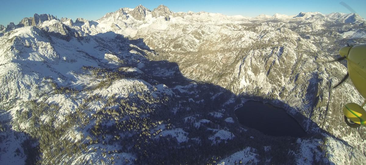
Lee side of Ritter Range
post-6-0-58631000-1383151117.jpg


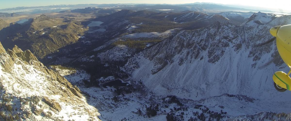
Descending into June Lake
post-6-0-68808900-1383408843.jpg


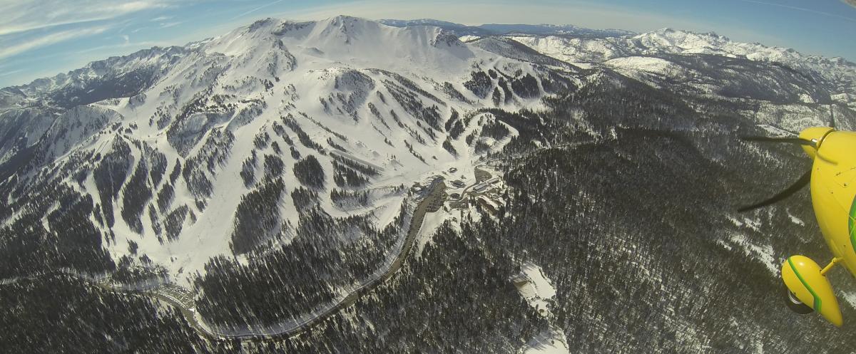
Mammoth Pass at Mammoth Mountain
post-6-0-09385000-1392148111.jpg
 
OK what about flying from San Carlos (San Fran Area) to Vegas next week.
KSQL ECA OAL BTY KHND
Are the winds better now than March or is the South route still the way to go?

Looks good, Winds have been light but today front is coming through and we expect a foot of snow tonight.

Winds tend to be good this time of year through winter, in between fronts. During this extended drought, lots of good weather.
 
Mammoth CAN have violent winds, but it doesn't always. If you know how to read and forecast winds through high passes, they can be avoided. But I really wouldn't advise it on a schedule. A last minute no-go is much more likely than a lower terrain crossing. And you do have to be prepared to turn back if you discover a strong wind at altitude, especially if it's westerly. I've been through Tioga in an unforecasted 20 knot north wind. While that doesn't make mountain waves, it does make moderate turbulence in the pass and requires loitering on the south side. Not pleasant, and I had to climb to 13000 so my passengers could keep their breakfast down.

The big risk is that an emergency landing in that part of the Sierra in the winter is very likely to be fatal. There are plenty of survivable landing sites, but rescue is not likely, and walking out in winter is not possible. Think Donner party. They got stuck at 6500 feet. In October.

Corona is silly. So is Cajon. You would have to cross terrain higher than Tehachapi to get there. I wouldn't go further south than Palmdale. Hwy 14 doesn't go east. It goes north to 395. The driving trip would use 58 to Barstow, but that's R-2515. If you can identify 138, you can use it, but I'd just use PMD VOR to find I-15.
 
Last edited:
I've flown this route in turbos dozens of time and normally aspirated maybe a couple of times.

I didn't catch the little detail that this is a winter flight. In that case I agree with Charlie Tango... it can be done between weather systems if the winds are light. I'm still not convinced about having 3 dudes on board a Cherokee 180, though.

I went the long way in my Archer II because it was July and the DA's were such that I had no other choice.

Thanks for posting the pix, CT. They bring back memories of what really is spectacular scenery.
 
Back
Top