Confusing GNSS MEA

ARFlyer

En-Route
Joined
Dec 31, 2011
Messages
3,182
Location
Central AR
Display Name

Display name:
ARFlyer
While going over Low Enroutes with my student, I came across something I've never seen before. Even the other II couldn't figure it out.

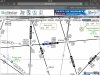
I have attached a picture of the area in question.

On the airway between WIGAN - BOWAN there is what I see as conflicting GNSS MEAs. The T-Route designation for that section has the MEA as 6100G, while the V-Route designation has it at 5000G. I do not see any crossover points, route notes or MEA flags.

So which MEA do you follow ? Is it based on which designation you filed, if your using INS, or some other reason?
 

Attachments

  • image.jpg
    image.jpg
    229.8 KB · Views: 92
First, it only matters for lost comm (otherwise you fly what ATC says) or for a cruise clearance, or if you're cleared for the approach prior to the IAF. Second, it depends on which airway ATC cleared you to fly or, if you're lost comm, told you was expected beyond your clearance limit before you lost comm. The route you filed only matters if you're lost comm and ATC hasn't given you a cleared/expected route beyond your clearance limit.
 
Last edited:
Huh on Ron's or my post? :D

Huh on why the variations on MEA/G unless there is some technicality on a Tango route that plays into the MEA calculations other than terrain clearance since you would not need VOR nav signal coverage.
 
Huh on why the variations on MEA/G unless there is some technicality on a Tango route that plays into the MEA calculations other than terrain clearance since you would not need VOR nav signal coverage.

Yeah, it does not make any sense.
 
You'd have to ask the people in the basement at FAA HQ who do these computations why they are what they are, or maybe Wally Roberts or John Collins here can help. However, from an operational/training standpoint, what I put in post #2 should be sufficient.
 
Found a previous discussion on same topic:

http://www.pilotsofamerica.com/forum/showthread.php?t=37151

Looks like Tango Routes MEA ensure obstacle clearance AND communications reception while Victor MEA is has no com requirements. So it is possible at 5000' there is not adequate communication coverage.

Copied from above post:

In the July 1, 2005 issue of the Federal Register (found at: http://www.federalregister.gov/artic...tes-rittr#p-18) it says: “RITTRs would be depicted in blue on the appropriate IFR en route low altitude chart(s). Each route depiction would include a GNSS Minimum En route Altitude (MEA) to ensure obstacle clearance and communications reception.”
 
Last edited:
#2 should be sufficient.

Having just completed instrument training and with all we are taught about FAA regulations and why things are the way they are...ESPECIALLY in training, post #2 does not answer the question of "WHY" it is. Yeah, in real world flying operationally it will never be an issue but that does not preclude the need to understand the charts and what it means.
 
Last edited:
Found a previous discussion on same topic:

http://www.pilotsofamerica.com/forum/showthread.php?t=37151

Looks like Tango Routes MEA ensure obstacle clearance AND communications reception while Victor MEA is has no com requirements. So it is possible at 5000' thre is not adequate communication coverage.

Copied from above post:

In the July 1, 2005 issue of the Federal Register (found at: http://www.federalregister.gov/artic...tes-rittr#p-18) it says: “RITTRs would be depicted in blue on the appropriate IFR en route low altitude chart(s). Each route depiction would include a GNSS Minimum En route Altitude (MEA) to ensure obstacle clearance and communications reception.”

The consensus I gathered was that it was a charting error. However, this isn't the only occurrence on that chart.
 
You'd have to ask the people in the basement at FAA HQ who do these computations why they are what they are, or maybe Wally Roberts or John Collins here can help. However, from an operational/training standpoint, what I put in post #2 should be sufficient.

We know they never, ever make misteaks.

I suspect it is getting worse with the decommissioning of VORs combined with the issuance of T Routes. Lots of activity.

Someone who cares should report it to Aero Nav.
 
Last edited:
We know they never, ever make misteaks.

I suspect it is getting worse with the decommissioning of VORs combined with the issuance of T Routes. Lots of activity.

Someone who cares should report it to Aero Nav.
Can you explain what makes you think it's a "misteak"?
 
Too many altitudes.
I'm not seeing that. There's one MEA for the T-route, and an MEA, G-MEA, and MOCA for the V-airway. I don't see anything excessive about that, since the T-route and V-airway have different requirements for their MEA's (comm requirement for T-route but not for the V-airway).
 
Ron, do you have a reference for the "G" minimum altitude on a Victor airway not providing communication coverage? According to the FAA Chart User's Guide,
GNSS MEA for each segment is established to ensure obstacle clearance and communications reception. GNSS MEAs are identified with a “G” suffix.
 
I'm not seeing that. There's one MEA for the T-route, and an MEA, G-MEA, and MOCA for the V-airway. I don't see anything excessive about that, since the T-route and V-airway have different requirements for their MEA's (comm requirement for T-route but not for the V-airway).

Where do you get the idea there is not a comm requirement for Victor airways?
 
Where do you get the idea there is not a comm requirement for Victor airways?
For MEA? From any one of a bunch of FAA publications, starting with the AIM:
MINIMUM EN ROUTE IFR ALTITUDE (MEA)- The lowest published altitude between radio fixes which assures acceptable navigational signal coverage and meets obstacle clearance requirements between those fixes. The MEA prescribed for a Federal airway or segment thereof, area navigation low or high route, or other direct route applies to the entire width of the airway, segment, or route between the radio fixes defining the airway, segment, or route.
Signal coverage and obstruction clearance only -- nothing about comm. Same in the Instrment Procedures Handbook:

Minimum En Route Altitude (MEA)​
The MEA is the lowest published altitude between radio fixes that assures acceptable navigational signal coverage and meets obstacle clearance requirements between those fixes. The MEA prescribed for a Federal airway or segment, RNAV low or high route, or other direct route applies to the entire width of the airway, segment, or route between the radio fixes defining the airway, segment, or route. MEAs for routes wholly contained within controlled airspace normally provide a buffer above the floor of controlled airspace consisting of at least 300 feet within transition areas and 500 feet within control areas. MEAs are established based upon obstacle clearance over terrain and manmade objects, adequacy of navigation facility performance, and communications requirements.
 
Last edited:
For MEA? From any one of a bunch of FAA publications, starting with the AIM:
Signal coverage and obstruction clearance only -- nothing about comm.

That's assuming a whole lot.

From TERPs VHF airway criteria:

1718. MINIMUM ENROUTE INSTRUMENT ALTITUDES (MEA). An MEA will be established for each segment of an airway/route from radio fix to radio fix. The MEA will be established based upon obstacle clearance over the terrain or over manmade objects, adequacy of navigation facility performance, and communications requirements. Segments are designated West to East and South to North. Altitudes will be established to the nearest 100 foot increment; that is, 2049 feet becomes 2000, and 2050 feet become 2100.
I note that it says "communication requirements", not "assures 2-way radio communications" or something like that, and there are no criteria in that Order for "communications requirements". And I know for a fact that I've been places where you're out of comm range at the MEA.
 
I note that it says "communication requirements", not "assures 2-way radio communications" or something like that, and there are no criteria in that Order for "communications requirements". And I know for a fact that I've been places where you're out of comm range at the MEA.

You would have to speak to flight inspection about that. They, and the affected ARTCC have to concur where a communications gap may exist along a Victor airway segment. It obviously cannot include compulsory reporting points. I'm sure they have the same issue with T routes.

None of this makes the extra MEAs the OP posted valid.
 
You would have to speak to flight inspection about that. They, and the affected ARTCC have to concur where a communications gap may exist along a Victor airway segment. It obviously cannot include compulsory reporting points.
So 2-way comm is not guaranteed. Thank you.
I'm sure they have the same issue with T routes.
Not according to the link Shawn posted above in post #8, which says T-route MEA's do guarantee communications reception. That would certainly explain a higher MEA for the T-route than for GPS nav on the V-airway. I would also note that segments of V292 and T295 for which those MEA's apply are not identical even if they are coincident between BOWAN and WIGAN. It's not at all unthinkable for the G-MEA for that portion of V292 (which applies from BAF VOR to SAGES intersection) to be the same as the MEA for that portion of T295 (which applies from SASHA intersection to SAGES).

None of this makes the extra MEAs the OP posted valid.
Doesn't make them invalid, either.
 
Last edited:
So 2-way comm is not guaranteed. Thank you.

Please don't try to change the meaning of what I said. Communications are flight inspected and assured with the very limited exception I stated. No one guarantees it will work with your old Narco gear, though.

That chart the OP posted is messed up, period.

I'd like to see your ground school on it. That would be a hoot.
I don't see anything "messed up" about the MEA's for two different segments being different, or the MEA's for "comm required" on a T-route and "comm not required" on a V-airway, being different, but perhaps I'm missing something. I'm certainly willing to be educated on that. And again, I would emphasize that the T-route MEA covers a different route segment than the V-airway G-MEA.
 
Back
Top