Cloud formations

Matthew

Touchdown! Greaser!
Joined
Apr 18, 2005
Messages
18,698
Location
kojc, kixd, k34
Display Name

Display name:
Matthew
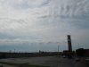
I took this series of pictures out the car window on Sunday - about 10:30am CDT.

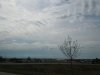
What caught my eye was the formation in the distance, just above the horizon. A series of what looked like flattened CB.

I didn't get a chance to get a better shot, since I was in the car aiming out the window, so I hope they show up OK on the attachments.

The view is looking SE, and the winds were out of the north.

Anyone know what those are called? How they are formed? What they indicate?
 

Attachments

  • Photo 001-small.jpg
    Photo 001-small.jpg
    155.7 KB · Views: 104
  • Photo 002-small.jpg
    Photo 002-small.jpg
    151.1 KB · Views: 79
  • Photo 003-small.jpg
    Photo 003-small.jpg
    174.5 KB · Views: 64
They look like lenticular clouds, though I gather it is pretty flat terrain in your area. Perhaps part of the cloud streets visible top center.
 
They look like lenticular clouds, though I gather it is pretty flat terrain in your area. Perhaps part of the cloud streets visible top center.

Yeah, pretty flat here - SW of Kansas City. I've seen cloud streets here before, but not lenticulars, that's why they caught my eye.
 
defintely wave-form from something. perhaps reflecting off the river valley or something. it doesn't take a large elevation change to get some wave going. now that you are flying gliders you'll notice this kind of thing a lot more.

could also be formed from some atmospheric effects, like different airmasses over/under each other. the obstacle creating the wave does not have to be terrain
 
Definitely waves. We see that all the time a little further West of you on the lee side of the Rockies.

Can mean a rip-roaring eastbound tailwind that'll shake your teeth out of your skull too if you're at the wrong altitude.

Airliners inbound from the West jus looooove descending through that stuff to land at DEN. ;)
 
cumulusclouds.jpg
 
defintely wave-form from something. perhaps reflecting off the river valley or something. it doesn't take a large elevation change to get some wave going. now that you are flying gliders you'll notice this kind of thing a lot more.

could also be formed from some atmospheric effects, like different airmasses over/under each other. the obstacle creating the wave does not have to be terrain


The cloud streets in the foreground are approx aligned with the direction the wind was blowing (surface winds were from the N, left-to-right in the pictures - I didn't check to see what the winds-aloft were doing at 1330Z on the 24th). That topography down in that direction is mainly rolling farmland.

I've read the books, the AFH and Glider Flying Handbook, that explain the formations. This is the first time I've noticed lennies, though. You're right, glider flying has me really trying to read the sky now.
 
No one mentioned K-H waves.
http://weather.about.com/od/cloudsandprecipitation/p/KelvinHelmholtz.htm

RE: OP's 1st picture...I'd say these are the visual vestigal remnants of K-H waves...due to lack of moisture. Certainly the atm is unstable...just like what CU indicates except the K-H also indicates a shear level aloft.

That's a pretty cool picture.

Regarding the photos I took, they were all taken about 20-30 seconds apart from a moving car. The exposures might be slightly different, making the photos look like there were taken at different times or from different locations, but all 3 show the same thing.

I did find the METAR from that time period:

KOJC 241353Z 10006KT 10SM BKN100 08/04 A3007 RMK AO2 SLP183 T00830044
>
--->photos were taken at approx 1330Z
>
KOJC 241253Z 06006KT 10SM CLR 07/04 A3004 RMK AO2 PRESRR SLP174 T00720044

The photos were taken about 4NM west of the airport and show the clouds at some distance to the south of the airport.

edit: I did manage to generate a skew-T for that location, time, and date (I think I did, I'm not very good at using that tool).
 

Attachments

  • skew_t_24_apr_11.bmp
    1.1 MB · Views: 4
Last edited:
No way will I argue with ScottD but I have seen K-H waves as low as 800 msl and approaching the headlands from over the Pacific ocean. I have a series of pictures to prove it. I'll hunt for the pics and post them.
 
Back
Top