Chicago to Daytona Beach

gprellwitz

Touchdown! Greaser!
Joined
Jun 19, 2005
Messages
12,762
Location
Romeoville, IL
Display Name

Display name:
Grant Prellwitz
Well, we've settled down in Daytona Beach after dodging T-Storms. Leslie'll be doing a writeup, but here are some pics of some of the T-Storms and the restaurant on the field at Big Sandy, which was a REALLY nice spot to divert to. Of course, once there we decided that we'd divert back the OTHER way to avoid more storms building along the coast.

Consequently, we got in much later than we'd anticipated, and the FBO we'd planned to use (Lynch) had already closed, but there was another (SheltAire) open for another half hour so we were alright. Unfortunately, I think it's a bit more expensive. :(
 

Attachments

  • IMG_0317 (Large).JPG
    IMG_0317 (Large).JPG
    25.9 KB · Views: 36
  • IMG_0308 (Large).JPG
    IMG_0308 (Large).JPG
    49.6 KB · Views: 32
  • IMG_0311 (Large).JPG
    IMG_0311 (Large).JPG
    108.8 KB · Views: 32
Wow that was a bigun Grant! Easy enough to spot though glad it wasn't imbedded
 
Have a great trip Grant! Glad you got through all the bad stuff. Let us know how it goes.

Best,

Dave
 
And so, we begin the tale of summer x-c flying, and the value of good weather briefers.....


Left 1C5 on Friday, June 15 about 11 am. We planned to get out earlier that morning, but having been up until close to 1 am the night before with flight planning etc, I needed the sleep.

We guessed the flight would take about 6 hours total, and while the trusty 182 could make it that far in one shot, we opted to break it into two legs, and stop at Rockwood municipal airport (RKW) in Tennessee, refuel and continue. In speaking with the briefer on the ground (got a good one this trip - courteous, knowledgeable too!), it would also give us an opportunity to check the weather en route, as many of the tafs indicated a potential for afternon thunderstorms around 19Z.

It was getting kinda warm on the tarmac at 1C5, and while we were able to depart OK, getting to our assigned altitude of 7K feet took a bit of time. Made me think, 'getting off the ground at a higher altitude will be interesting...'

It's VFR most of the way, and we make it down to Indianapolis pretty much per our flight plan, when Indy approach had to vector us east to make room for departing traffic. Its also starting to get a bit hazy at 7, so we request 9K as our altitude. It's close to time for us to be handed off to another controler, so he recommends that we repeat our request there. The next controller does give us the new altitude, but.. in our initial call, I forget to indicate that we've been temporarily diverted. Takes him a while to ask, 'what's your oncourse heading?" which, of course, is far from the one we're on. We weren't quite in Dayton's airspace, but we were certainly well on our way...

We get cleared to resume our on-course heading, and turn south/southwest - to see a rather impressive line of thunderstorms starting to pop up in that direction. Doesn't look very promising, but they're far out enough that we have time to think of our options. Seems like the storms are heading southeast; doesnt look like there's anything building up farther west, but we weren't sure if more were to come. Get the Hiwas, learn those cells are up around 40K feet +, and they were moving about 25 kts towards our intended destination. They may be slow, but they were ahead of us - most likely we'd be trying to land along with them.

So, time for diversion #1; pick an airport farther out to the southeast, keeps us in the general direction, but we have a better chance of making it down before things get hairy. And that cell line was getting closer. All of the appropriate references (runway length, field conditions, instrument approaches, restaurant availability) were consulted, and we opted for London-Corbin airport in London, KY as our diversion point. We get clearance, and begin to head southeast... but it doesn't look like we're going to clear that TS line on its east side on that heading. Convective sigmets are now on the move, and London ain't lookin so pretty...

So, we consult again, and it's time for diversion #2, this time for something closer to east. As we move into the light chop turbulence and small cumulus clouds that are starting to slightly build up below our altitude, with the taller cumulus and CB ahead, We decide on Big Sandy Airport(K22) in Prestonburg, KY. Heading 096, getting away from those storms.

We come in to make the GPS approach for runway 3. I'm under the hood, Grant's looking outside. At the MDA, he says, 'yeah, you really don't want to descend anymore.' I look up, and here in coal country, I can see the runway ahead - right after a hill that's between us and it. Did I stick at that MDA until we cleared it? - you betcha! then dropped the barn doors afterwards when we were in the clear.

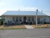
After 3.5 hrs in flight so far, we landed on a well maintained runway, and went to the restaurant a short walk (maybe a hundred feet or so) behind the FBO for a rest and some eats. (There was a medical helicopter team based there as well, and they and the FBO owner said it was a good thing we landed when we did, that there was some bad news weather to the south.) The Cloud 9 cafe is run by the FBO owner's daughter, and the food was excellent. The ribs were only available after 4 pm, and while we had to wait a few minutes, it was well worth it - literally falling off the bone....

Interesting thing; from the ground, a hazy, lazy afternoon sky looks so deceiving as to what's actually happening up there. Going in to check weather at the FBO, we get the story... thunderstorms going up to 42,000 feet and up, popping up like popcorn all over TN, Southern KY, and into Georgia :eek: . both of our previously considered airports (original interim destination and the first diversion) had some heavy cells around them at the time we would have landed. Considered going east to the coast, then down to FL but the cells were moving southeast, and there was a cluster of actvity in Savannah that would block us.

In speaking with the briefer (for quite a long time; and he was good too), it seemed that some of the cells were starting to die down (or, better put, not fire up any new cells) in the northwest corner of the storm block, and what was out there was moving to the south and southeast. If we were to proceed, our best bet would be to head out, go west from our current position, start heading south and east by picking our way around some cells, then head south after the storms start to dissipate (it's getting close to 6 pm eastern at this point).

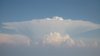
We thank the briefer, head to the trusty 182. Looking to the southeast, we see one of the domed thunderstorm cells that Grant took a photo of, said, 'let's not go that way' :no: 
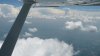
, then departed rwy 3 to turn west. We filed for 11K, and began our climb out. Good thing we had some altitude, as the sky went from few to scattered to broken pretty quickly below us; if we were lower, we wouldn't have been able to fully appreciate what else was out there...

(part 2 in next post)
 
Space Shuttle scheduled to land on Thursday, wx permitting. You might get to hear the double boom if you're still in the area...
 
Leslie flew the entire flight! I think she logged about 8 hours PIC.
 
Actually, it was 8.5 well-earned PIC hours. The saga continues....

After taking off from Big Sandy, we requested a climb to 11,000 feet. Between going west, and having to hold for higher traffic, we were only cleared to 8,000 feet to start. Since the sky had started to cloud up quite a bit below us, we focused on the cells we could see above the layer. And, they did not disappoint; the clouds were beautiful and striking, but also something we didn’t want to get too close to. We knew we’d be picking our way through these for a while; ‘diverting for weather’ was the phrase that paid.. As in, soon after verifying our initial heading (which would have sent us through one of those beautiful clouds), the controller comes on with, “uh, I see some convective activity and cells ahead along your route of flight, do you concur?” Our response: ‘sure do, like to deviate to the west for weather.” We weren’t alone, heard many others on the frequency diverting as well.

And so it went for a while; divert to give the cell some space, attempt to proceed direct when you got to the point where you could look around the cells to see what was ahead, and go from there. While we were eventually cleared to 10,000 feet, one difficulty was that, since we didn’t have on-board weather (no, this is not a veiled advertisement for the 496, even though it sounds that way), it was tough to know if the rest of our route would be clear. The controllers on the approach level only had radar that went out to a certain point. So, we requested a frequency change to talk to flight watch…

And, on Atlanta Flight Watch, we connected with what I consider to be one of the most helpful and hard-working briefers I’d ever spoken to :yes: . I don’t have his name, but this guy was amazing in helping to give us an idea of the weather ahead, where cells were moving, how they’d affect our route, and suggestions for how to alter our route to pick around and behind these cells to get to DAB. Not being extremely familiar with the terrain, his information and advice was invaluable. When we had to leave to go back to approach or center, he’d say “okay, we’ve got a good picture through Dublin. Call me again when you get there, and we’ll see how the rest of the route looks.”

We keep going like we’re in a pinball game, and call him about 40 minutes later at Dublin. By now, he’s working more than one frequency, and he’s having communication troubles with his equipment; one of the frequencies isn’t transmitting well. We were going into nighttime, and I was somewhat nervous about any thunderstorms out there that I can’t see. But, rather than just call it, we continued to speak with this guy on two different frequencies, and he kept working with us. I can only imaging multiplying his workload by the number of aircraft he was tracking… but he got us through to Valdosta without coming into contact with any of the storms, and the skies finally started calming down after that. There were some areas of moderate to heavy precip, and we stayed out of those as well.

So, the weather finally calms down, and we hear a long beeeeep….. seems that the autopilot is rather tired, because it just went offline ! :mad: Circuit breaker wasn’t popped, and we can’t figure out what the deal is. Luckily the plane is in smooth air, and with GPS and VORs keyed in for backup, we appear to be keeping reasonably well on our course at the moment. Pull and reset the circuit breaker, no dice. Leave it out for a while, try again; still no luck. The electric trim went out along with it; not a huge deal, since I seem to reach for the manual trim wheel out of habit even when the electric trim is working J. We fly along, wait, I’m watching the other instruments to make sure we’re not starting some sort of cascade failure here, and… the autopilot comes back on with the next retry.. . It’s still not clear what happened, but things appear to be on track again.

We fly on, to an area where the terrain is at about 6,000 – 7,000 MSL due to mountains, and now we get the RAIM error message! Luckily we had the VOR frequencies already in for cross tracking, and it seemed that the GPS re-acquired the satellites it needed, because our course didn’t deviate much at all.

Finally get transferred to Jacksonville center – almost there. Somewhat quiet until we get to Daytona approach. Got to think the controller there was having a bad day; he had us, and claimed he couldn’t hear our returning his radio calls (although we’d responded to all of them, so we really spoke slowly and clearly on all of the remaining ones), also had what sounded like a private student whom he wasn’t sure was aware of a restricted area she was apparently getting somewhat close to, and another pilot (IFR?) who was proceeding to an intersection that wasn’t on the clearance the controller was given to work with. I’m ready to get out of this guy’s airspace..

We get the visual for runway 7L, but it was difficult for us to make out the airport. Got vectors most of the way in, keyed in the ILS for 7L to confirm we were where we thought we were, and came in for landing on a runway that was nicely lit up by the tower controller. Taxied over to the late night FBO; turned off the engine at 11 pm, gave the trusty 182 a pat on the engine cowling for a job well done, and piled into a taxi for the ride to the hotel.
The second leg was 5 hours of flying, given the diversions. I’m glad we were up at higher altitudes; in addition to being able to see the cells, it also allowed us to lean things out; I’m guessing we had between 60-80 minutes of fuel left when we landed.

In all that flying, I learned a lot about:
- The value of a good instructor in keeping one’s cool among less than perfect weather and instrument conditions
- Teamwork with all of your available resources, in and outside the cockpit (somebody at the FAA is getting a kicka$$ ‘thank you’ letter from me)
- How to get one’s body into ‘camel mode’ to fly a long stretch if you have to J
- How an IFR clearance can be used as much to avoid bad weather as to just fly in the clouds.


I love a challenge, but I’d just as soon have a less eventful ride on the way home.

Leslie
 
Well, we came back over the past two days. The first day was "VFR" from Daytona Beach to New Smyrna Beach, FL, to Smyrna, TN. Both of the Smyrnas were available on ConUS Challenge, so I targeted them. We had taken the bus from Daytona Beach to Ponce Inlet on Friday, where we had lunch watching the planes do pattern work at New Smyrna Beach. It seemed like a nice little airport, and I was able to see the tower from the top of the Ponce Inlet Lighthouse, at 173'.

We left New Smyrna up along the seashore at 500'. Around Daytona Beach, just off from the hotels we stayed at, we had to veer inland a little to avoid both parasailers and a biplane banner tower. Once we got north of Ormond Beach we were cleared to 3500'. We stayed relatively low until about 15NM south of Jacksonville, at which point we started a climb and turned direct to Smyrna.

While the weather was VFR, the visibility wasn't great, and we started getting some buildups as we got into Georgia. We were threading our way between buildups at 10,500', and skirted the south and western sides of Atlanta's Class Bravo. Soon after that, we climbed to 12,500' to stay above the buildups. While we were truly VFR, I wouldn't have felt comfortable were we not with VFR traffic advisories and with the capability of filing should things start south. At 12,500, we were limited in the amount of time we could spend at altitude, but we were less than an hour away from our planned fuel stop of Smyrna. I did a slow ascent to 12,500, and we stayed there for about 15 minutes before starting the descent.

Throughout this time we were talking to Flight Watch to determine how the Radar was looking. Since we weren't in the Turbo 182, we didn't have a storm scope, so we were relying on radio communications. We actually found on all legs of our ttrip that Flight Watch was very helpful, and timely to boot. When we called Flight Service from the land line, I don't think we had to wait more than 15 seconds, either, and the personnel were actually fairly knowledgeable. I'd rate tham a B+ or A-, and admit to a little surprise in giving them such a high mark.

The haze was bad enough that we didn't have Smyrna, TN definitively in sight until we were within about 5NM. We were cleared straight in, and chose one of the two FBOs pretty much at random. More on that in the next posting.
 
As I said in the last posting, we were able to definitively make out the runways at about 5NM. Nashville Approach turned us over to Smyrna Tower and we were cleared to land. We taxied to the first FBO, the Smyrna Air Center, and were warmly greeted. We checked the weather, and quickly decided that we would spend the night there. There was a line of thunderstorms between Smyrna (in the Nashville area) and our destination of Chicago. We watched it into the evening, and it spawned tops of 60 - 70 thousand feet. Those are significant tops!

The FBO gave us a ride to a hotel about 5 miles away, and picked us up again in the morning. We checked the weather in the hotel, and again in the FBO. The line was coming up again, but we were able to break west to Land between the Lakes, after a discussion with flight services, then north almost direct to Chicago. We had a few diversions along the way for the Campbell restricted area and some buildups, but made a nice flight back at 6,000'.

After we got back, we found that the route behind us had largely closed up; enough, at least, that I wouldn't have been willing to try it.

Lesson learned: When flying in the summer, leave EARLY!!!
 
Grant/Leslie, great write up. I wish I knew you were going to be making a stop in Smyrna as I'd have made a run over and bought lunch/supper. (Our plant is in Smyrna so there is a built in excuse to head over that way)
 
Actually, it was 8.5 well-earned PIC hours. The saga continues....In all that flying, I learned a lot about:
- The value of a good instructor in keeping one’s cool among less than perfect weather and instrument conditions
- Teamwork with all of your available resources, in and outside the cockpit (somebody at the FAA is getting a kicka$$ ‘thank you’ letter from me)
- How to get one’s body into ‘camel mode’ to fly a long stretch if you have to J
- How an IFR clearance can be used as much to avoid bad weather as to just fly in the clouds.


I love a challenge, but I’d just as soon have a less eventful ride on the way home.Leslie
Remember a couple of weekends ago when we were chatting up at Clow? I'd just gotten home on a trip like that.....they're ALL like that....
 
Yeah, we were talking about how real-world IFR flying is so different than what we do during training. OTOH, I got a real dose of doing a missed today. We were on the GPS-B to 1C5 just at the FAF when we got the RAIM unavailable message. So we kept flying toward the missed and radioed back to Chicago approach that we were going missed because we lost RAIM. They came back, saying "I don't know what that is", at which point I just said "we lost our GPS and need to come back around for the VOR-A." They gave us vectors and I got to do BOTH our approaches into 1C5 for real today. I think we broke out around 1900'. Yeah, there were folks doing pattern work with that, and the pattern is 1500'. We entered on the crosswind.

The best part is that the nearby weather reporting at Lewis, 5NM south, was reporting 900' scattered 10 minutes before we got there and clear below 12,000' at our arrival time. It was CLEARLY an overcast around 1900', give or take a couple hundred feet. IT LIED! :)
 
Grant/Leslie, great write up. I wish I knew you were going to be making a stop in Smyrna as I'd have made a run over and bought lunch/supper. (Our plant is in Smyrna so there is a built in excuse to head over that way)

We hadn't initially intended to overnight there. Once we decided to, I did think of posting to the board and see if anyone wanted to get together, but we found other things to occupy our time. :blowingkisses::yes:
 
Back
Top