Can someone please explain this question to me?

CARoss

Filing Flight Plan
Joined
Sep 24, 2007
Messages
22
Location
Portland, OR
Display Name

Display name:
Chris
Just took my Private Pilot:Rotorcraft:Helicopter FAA Knowledge Exam (via Lasergrade). Passed!

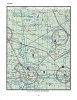
BUT, there was one question that plagued me... ASA Question #3622, Page 9-44 of the ASA Private Pilot Test Prep 08 book.

For the curious,

20080505-96dt634eikw76y36fxtmnnrus.jpg


If I look at my supplemental material book, Figure #27, I don't have the "The blue circle in the bottom left corner of Figure 27 indicates Lowe airport lies in Class G airspace from the surface to 1,200 feet AGL".

Do you?

Looking at the possible answers,
you can eliminate A, Golf does not go up to 18k MSL.
you can eliminate C, Since Echo does not end at 14.5kMSL

So, that leaves you with B... which is the right answer. But, I really hate to think that is how you are supposed to figure this out.
 
Actually, class G can go up to FL 180 and beyond.

Aside from that little trivia item, I think you have it - process of elimination and finding the "best" answer.
 
So long as you stay out of controlled airspace near airports, class G extends from the ground up to but not including 1200 AGL, no?

Is there somewhere that the ground extends above 10,000 MSL, or 18,000 MSL? ;)
 
My test prep materials are a few years old, but I see the "blue circle" in Figure 27 that they're talking about. Only thing is, it isn't a "blue circle", it's just a tiny bit of "fuzzy blue arc", cutting across the lower left hand corner of the figure.

If you don't see this in your figure (I suspect it's there, but you're looking for a "blue circle"), go to www.skyvector.com and go to "JMS", this is the lower left hand corner of the chart. To the Southwest of JMS you'll see a "fuzzy blue arc". This tells you that unless otherwise marked, class G turns into class E at 1200 AGL here. For an example of "otherwise marked", you'll notice that KJMS is surrounded by "fuzzy magenta arc", and so class G turns into class E at 700 AGL.

In any case, this snippet of blue arc shows that Lowe Airport is inside the "fuzzy blue", and thus it's class G from the surface up to 1200 AGL, then it's class E up to 18000MSL, where it turns into Class A.
-harry
 
Ok, you win the... well, you win a.... lightning bolt: :lightning:

All I have to offer... thanks.

Yup, that is exactly it. Blue Waterfall arc... that would have told me 1200-Echo. PUNKS! That's really sleazy of them... but, it is there... ok.

Thanks, I will sleep better tonight.


My test prep materials are a few years old, but I see the "blue circle" in Figure 27 that they're talking about. Only thing is, it isn't a "blue circle", it's just a tiny bit of "fuzzy blue arc", cutting across the lower left hand corner of the figure.

If you don't see this in your figure (I suspect it's there, but you're looking for a "blue circle"), go to www.skyvector.com and go to "JMS", this is the lower left hand corner of the chart. To the Southwest of JMS you'll see a "fuzzy blue arc". This tells you that unless otherwise marked, class G turns into class E at 1200 AGL here. For an example of "otherwise marked", you'll notice that KJMS is surrounded by "fuzzy magenta arc", and so class G turns into class E at 700 AGL.

In any case, this snippet of blue arc shows that Lowe Airport is inside the "fuzzy blue", and thus it's class G from the surface up to 1200 AGL, then it's class E up to 18000MSL, where it turns into Class A.
-harry
 
For those wanting to see the figure without downloading a huge file, I've extracted figure 27 from the PDF file an turned it into a jpeg:
 

Attachments

  • Figure 27.jpg
    Figure 27.jpg
    633.7 KB · Views: 54
Even if the blue shading wasn't visible on the chart, A and C are worded so they are wrong without even looking at a chart.

(It's not an Alaskan chart - and you know G doesn't go to FL180 in the CONTIGUS, and E never stops at 14,500.)
 
My test prep materials are a few years old, but I see the "blue circle" in Figure 27 that they're talking about. Only thing is, it isn't a "blue circle", it's just a tiny bit of "fuzzy blue arc", cutting across the lower left hand corner of the figure.

If you don't see this in your figure (I suspect it's there, but you're looking for a "blue circle"), go to www.skyvector.com and go to "JMS", this is the lower left hand corner of the chart. To the Southwest of JMS you'll see a "fuzzy blue arc". This tells you that unless otherwise marked, class G turns into class E at 1200 AGL here. For an example of "otherwise marked", you'll notice that KJMS is surrounded by "fuzzy magenta arc", and so class G turns into class E at 700 AGL.

In any case, this snippet of blue arc shows that Lowe Airport is inside the "fuzzy blue", and thus it's class G from the surface up to 1200 AGL, then it's class E up to 18000MSL, where it turns into Class A.
-harry

Actually AFaIK, the Class G always tops out at or below 14,500 MSL unless that's below 1200 AGL. Between there and FL180 is Class E.
 
Is it just me, or is the zipper on the wrong side of the shading? Especially with a Victor heading through there?
The zipper is most likely there =because= of the airway. A lot of the zippers, at least in the west, are there because of terrain with elevations that vary up and down and up again over a short distance.

Take away that zipper, and you have terrain varying from about 7000 to over 14000, meaning Class E (including the airway) varying from about 8000 to over 15,000, over a span of less than 30 NM.

This isn't the only spot where the function of the zipper is to "smooth out the bumps" so to speak.
 
Silly flatlanders...

http://skyvector.com/perl/code?id=KANK

Look just to the south of Alexander field where Class G goes to...

I may be missing the point here, but it looks to me that the Class G ceiling at 15,500 is pretty close to 1200 AGL. Granted it's more than that but probably just to round it up a bit. And anyway my point was that 18,000 isn't the default class G top (when terrain isn't an issue), AFaIK that's 14,500.
 
I may be missing the point here, but it looks to me that the Class G ceiling at 15,500 is pretty close to 1200 AGL. Granted it's more than that but probably just to round it up a bit. And anyway my point was that 18,000 isn't the default class G top (when terrain isn't an issue), AFaIK that's 14,500.
I think the point was that you said
Class G always tops out at or below 14,500 MSL unless that's below 1200 AGL.
Just pointing our that there are areas where that's not true, like along US-285 just over the ghost town of Alder, CO, where it "tops out" at 15,500 MSL and about 8,000 AGL.

Of course, if what I quoted wasn't your point, that's ok too.
 
I think the point was that you saidJust pointing our that there are areas where that's not true, like along US-285 just over the ghost town of Alder, CO, where it "tops out" at 15,500 MSL and about 8,000 AGL.

Of course, if what I quoted wasn't your point, that's ok too.

But with a nearby 14,000 MSL peak, that 15,500 is about 1200 AGL. In this (and many other cases), 1200 AGL doesn't mean 1200 ft above the elevation directly below, if it did the tops of Class G would be shaped exactly like the underlying terrain.

IOW, I think the example you provided supports my contention.
We're obviously looking at the same information very differently.
 
...1200 AGL doesn't mean 1200 ft above the elevation directly below, if it did the tops of Class G would be shaped exactly like the underlying terrain.
Inside the "fuzzy blue" and "fuzzy magenta", the top of class G is 1200AGL and 700AGL, respectively, and is thus shaped exactly like the underlying terrain.

Outside the fuzzy blue, the top of class G is 14500MSL, and thus flat, unless the terrain reaches up above 13000MSL, in which case the top of Class G is 1500AGL, and thus once again is shaped exactly like the underlying terrain.
-harry
Ah, my second favorite FR airspace question :)

btw, lest anyone think that this is non-existent, look just west of Silver West airport for terrain where the lowest floor of Class E is 14,500 msl and the highest floor rises up and down above that with the terrain (without a smoothing zipper):
http://skyvector.com/perl/code?id=C08

And yes, this airspace is piston flyable, with Mosca Pass (in the southern portion of the strip) being a common route to cross those mountains.
 
Last edited:
Ah, my second favorite FR airspace question :)

btw, lest anyone think that this is non-existent, look just west of Silver West airport for terrain where the lowest floor of Class E is 14,500 msl and the highest floor rises up and down above that with the terrain (without a smoothing zipper):
http://skyvector.com/perl/code?id=C08

And yes, this airspace is piston flyable, with Mosca Pass (in the southern portion of the strip) being a common route to cross those mountains.

Okay - I'm game - what's your favorite airspace question? Great thread!!
 
Okay - I'm game - what's your favorite airspace question? Great thread!!
You are going to a non-towered airport that is in a Class E surface area. The ceiling is 1100. The normal traffic pattern is 800 AGL.

(a) can you land there?
(b) at what altitude will you fly the traffic pattern?
 
You are going to a non-towered airport that is in a Class E surface area. The ceiling is 1100. The normal traffic pattern is 800 AGL.

(a) can you land there?
(b) at what altitude will you fly the traffic pattern?

(a) Yes
(b) I'm gonna research after this, but I'm pretty sure there's no legality to TPA, so....I'd fly the pattern 500ft below the ceiling.
 
(a) yes
(b) I won't, I will do a straight in after executing the instrument approach

Oops. I left out part. It's a VFR flight.

It's actually not intended to be a difficult question (although some folks don't realize that you require a 1000' ceiling to land there VFR at all). It's mostly designed to generate a discussion on whether you fly the pattern at its normal altitude or, as SkyHog suggests, fly it at 600 AGL.
 
Last edited:
Okay, I love this - studying for my commercial written and you all have me back in the AIM, digging into the example on SkyVector, and loving every moment of it. Not much practical experience here in Chicago with Class G airspace!
 
Back
Top