You are using an out of date browser. It may not display this or other websites correctly.
You should upgrade or use an alternative browser.
You should upgrade or use an alternative browser.
Bridging the Gap
- Thread starter Lawreston
- Start date
BillTIZ
Final Approach
I believe the railroad bridge is gone. How old is this picture?
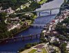
Your are looking south, down river.
Ft Western, one of Benedict Arnold's stops on his way up the Kennebec to attack Quebec during the revolutionary war.
Your are looking south, down river.
Ft Western, one of Benedict Arnold's stops on his way up the Kennebec to attack Quebec during the revolutionary war.
Lawreston
En-Route
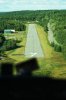
Bill: Photo was from August 18, 2014. We were returning from photography mission for Maine Island Trail Association; had done the Islesboro, Vinalhaven, surrounding areas of Penobscot Bay. We were minutes away from landing at Augusta to drop off my island spotter. The actual image from which I created the above version can be seen below(though I'll probably get keel-hauled for posting its size). Right click and Open in another window. In it, YOU can pinpoint the old Cony High School location, the large motel at "Cony Circle," Togus Veterans' Hospital(upper center left), "French-town"(bottom center), Water Street, the Maine State Liquor Commission, State Capitol and Offices complex and others. The airport is Stonington.
HR
[EDIT:] The airport aerial should have been in the #2 position. ???
HR
[EDIT:] The airport aerial should have been in the #2 position. ???
Attachments
Last edited:
Lawreston
En-Route
BillTIZ
Final Approach
Bill: Photo was from August 18, 2014. We were returning from photography mission for Maine Island Trail Association; had done the Islesboro, Vinalhaven, surrounding areas of Penobscot Bay. We were minutes away from landing at Augusta to drop off my island spotter. The actual image from which I created the above version can be seen below(though I'll probably get keel-hauled for posting its size). Right click and Open in another window. In it, YOU can pinpoint the old Cony High School location, the large motel at "Cony Circle," Togus Veterans' Hospital(upper center left), "French-town"(bottom center), Water Street, the Maine State Liquor Commission, State Capitol and Offices complex and others. The airport is Stonington.
HR
[EDIT:] The airport aerial should have been in the #2 position. ???
Thanks, so the RR bridge is still there. They took the dam just up river from the bridge years ago. That is not Togus, that is the old state mental hospital. Togus is about 15-20 miles east of the river on the road to Rockland. My Dad worked at Togus in the 70s.
Roger on Cony Circle, there was a fight to keep the old high school building for architectural historical reasons.
BillTIZ
Final Approach
Bill: Heading out from you know where.
HR
I worked there summer of '75, with Bill Perry Sr.
This is their new hangar/office building.