TangoWhiskey
Touchdown! Greaser!
You probably already know that the cities listed in BLACK ink on the L-chart coverage grid on the front of a Low-Altitude Enroute chart indicate busy cities for which an "A-chart" is available.
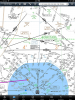
What I didn't notice before today is that the Low Altitude Enroute charts DO NOT SHOW THE AIRPORT IDENTIFIER for any airport inside the Area Chart details. Look at this snippet from L-17; airports to the north of the dashed green line have the airport identifier, altitude, lighting and runway length info. Airports to the south of the dashed green line, in the DFW metroplex area, don't even have the ID of the airport. Granted, not much of an issue with Foreflight (touch the airport, get the detail) or most GPS units (search by airport or city name), but I still found it to be an interesting trivia detail... better found on the ground than in the air! How'd I miss that before?

What I didn't notice before today is that the Low Altitude Enroute charts DO NOT SHOW THE AIRPORT IDENTIFIER for any airport inside the Area Chart details. Look at this snippet from L-17; airports to the north of the dashed green line have the airport identifier, altitude, lighting and runway length info. Airports to the south of the dashed green line, in the DFW metroplex area, don't even have the ID of the airport. Granted, not much of an issue with Foreflight (touch the airport, get the detail) or most GPS units (search by airport or city name), but I still found it to be an interesting trivia detail... better found on the ground than in the air! How'd I miss that before?
")