An Airspace Mystery

ARFlyer

En-Route
Joined
Dec 31, 2011
Messages
3,182
Location
Central AR
Display Name

Display name:
ARFlyer
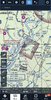
I had a pilot recently ask me what the purpose was for in this area of Class E south of Vicksburg, MS. When I pulled it up on ForeFlight I did a verbal WTF! It’s a square piece of 700’ Class E over nothing but swamps.

Anyone have any earthly idea why this exists?
 

Attachments

  • E2A874C5-4AFC-47D1-ABDC-14CD533E3E25.jpeg
    E2A874C5-4AFC-47D1-ABDC-14CD533E3E25.jpeg
    223.8 KB · Views: 188
Only thing I can see is a rectangular cleared area next to the river with a road that goes back to the power plant. Maybe a landing area for a helo? Who knows...
 
Only thing I can see is a rectangular cleared area next to the river with a road that goes back to the power plant. Maybe a landing area for a helo? Who knows...

Yeah that was my thought. But you’d think it would be centered over that area. The center of the box is a river bank with swamp land.
 
Nuclear plant just north and Windsor Ruins to the south. But both of those appear to be outside the box.

Certainly doesn't look like anything there to warrant the area being Class E.

CEAS.jpg
 
@aterpster , any reason this box would be Class E down to 700'? Normally these areas of E down to 700 are in conjunction with an approach, but this one IS a bit of a mystery.
 
Nuclear plant just north and Windsor Ruins to the south. But both of those appear to be outside the box.

Certainly doesn't look like anything there to warrant the area being Class E.

It’s a government conspiracy I tell ya!! :D
 
If you saw the mini-series on Grant, this looks like the place he crossed the river to capture Vicksburg. Completely irrelevant to the topic but interesting to me anyway.
 
If you saw the mini-series on Grant, this looks like the place he crossed the river to capture Vicksburg. Completely irrelevant to the topic but interesting to me anyway.

Is it related to the Windsor Ruins?
 
@aterpster , any reason this box would be Class E down to 700'? Normally these areas of E down to 700 are in conjunction with an approach, but this one IS a bit of a mystery.

You see ones that don't seem to make sense but they are round and over hospitals where there is a Special Instrument Approach for medivac helicopters. @Velocity173 , you ever seen a square one.
 
It's not a Charting error. It exists. But it don't say why.

ASO MS E5 Port Gibson, MS
Natchez VOR/DME
(lat. 31°37'06"N., long. 91°17'59"W.)
That airspace extending upward from 700 feet above the surface within 2.5 miles each side of the Natchez VOR/DME 027° radial extending from 20.9 to 27.2 miles northeast of the VOR/DME.
 
You see ones that don't seem to make sense but they are round and over hospitals where there is a Special Instrument Approach for medivac helicopters. @Velocity173 , you ever seen a square one.

The nuclear plant has a helipad there so it’s possible they’ve got an approach. No, never seen a square one. All of our approaches in my area, the hospital approach is already colocated in the airport 700 ft class E circle.
 
The nuclear plant has a helipad there so it’s possible they’ve got an approach. No, never seen a square one. All of our approaches in my area, the hospital approach is already colocated in the airport 700 ft class E circle.

Seems like the best reason so far!
 
Is it related to the Windsor Ruins?

Windsor Ruins are in Claiborne County, Mississippi, United States, about 10 miles (16 km) southwest of Port Gibson near Alcorn State University. The ruins consist of 23 standing Corinthian columns of the largest antebellum Greek Revival mansion ever built in the state. The mansion stood from 1861 to 1890, when it was destroyed by fire.

Grant probably stopped there for tea.
 
I was curious about this a couple of years ago: Nucular plant with private approach to the helipad was the best I could come up with
 
I was curious about this a couple of years ago: Nucular plant with private approach to the helipad was the best I could come up with

"Nucular....it's pronounced nucular."
-Homer J Simpson
 
FWIW, the NRC operates helicopters with radiation detectors. I wouldn't be surprised if there wasn't some sort of requirement to allow some sort of instrument let-down to be able to approach the facility at a low level in the event of an incident.
 
It if were an instrument approach to the power plant, it would be depicted on the chart with an H with a circle on it.

Additionally, the airspace that is depicted does not allow enough room for it to be TERP’ed.

This is an approach to the I-10 rest area and is served by a special use approach.

bfaf2b9c1bce217a1c3835ff313eae5f.jpg
 
Someone was drawing a rectangular airspace extension for some approach somewhere and transposed a couple digits. Now no one knows why it is there, but it can't be removed because "what if there is a reason for it?"
 
LOL. Without looking at chart revisions, there is a (very unlikely) chance that there was an airspace study done and that made it to the chart before the rest of the approach was approved.

The square depiction tells me it's not for an approach though.
 
I've seen that airspace before, and always wondered why the random box of Class E there. Figured it must have something to do with the nuke plant, but don't know the whole reason.
 
It if were an instrument approach to the power plant, it would be depicted on the chart with an H with a circle on it.

Only if the owner opts to have their heliport charted. There are plenty of heliports that dont show up on the sectional.

This is harvested from the FAA master airport record.

https://www.airnav.com/airport/3MS0

The helipad is next to the administrative building at the Grand Gulf Nuclear Station.


I dont know whether this would be big enough for private helicopter approach, but sometimes it looks like the FAA charts a rectangular class E cutout.

https://skyvector.com/?ll=39.447010652496914,-110.933349605113&chart=301&zoom=1
 
Last edited:
You see ones that don't seem to make sense but they are round and over hospitals where there is a Special Instrument Approach for medivac helicopters. @Velocity173 , you ever seen a square one.

The nuclear plant has a helipad there so it’s possible they’ve got an approach. No, never seen a square one. All of our approaches in my area, the hospital approach is already colocated in the airport 700 ft class E circle.

I was curious about this a couple of years ago: Nucular plant with private approach to the helipad was the best I could come up with

FWIW, the NRC operates helicopters with radiation detectors. I wouldn't be surprised if there wasn't some sort of requirement to allow some sort of instrument let-down to be able to approach the facility at a low level in the event of an incident.

I've seen that airspace before, and always wondered why the random box of Class E there. Figured it must have something to do with the nuke plant, but don't know the whole reason.

Only if the owner opts to have their heliport charted. There are plenty of heliports that dont show up on the sectional.

This is harvested from the FAA master airport record.

https://www.airnav.com/airport/3MS0

The helipad is next to the administrative building at the Grand Gulf Nuclear Station.


I dont know whether this would be big enough for private helicopter approach, but sometimes it looks like the FAA charts a rectangular class E cutout.

https://skyvector.com/?ll=39.447010652496914,-110.933349605113&chart=301&zoom=1

So I thought I’d pass this along to you guys since I asked the question. I got an answer regarding the airspace. It’s leftover from a OLD OLD COPTER VOR/DME Private Approach that has since been abandoned into the nuclear plant. It’s in the process of being removed and the airspace being returned to 1200’ Class E. But that take years so it will still be an archaeological specimen.

The FAF is still listed as an active waypoint. It’s listed as NUCIE which I find quite humorous.
 
I volunteer the OP to fly in there and land. Then see what happens for an hour or so. :)
 
So I thought I’d pass this along to you guys since I asked the question. I got an answer regarding the airspace. It’s leftover from a OLD OLD COPTER VOR/DME Private Approach that has since been abandoned into the nuclear plant. It’s in the process of being removed and the airspace being returned to 1200’ Class E. But that take years so it will still be an archaeological specimen.

The FAF is still listed as an active waypoint. It’s listed as NUCIE which I find quite humorous.

Could it be? We actually got a straight truthful answer to a question asked on POA?

Thanks for the answer!
 
I volunteer the OP to fly in there and land. Then see what happens for an hour or so. :)

I don’t much care for the taste of asphalt! :D

Could it be? We actually got a straight truthful answer to a question asked on POA?

Thanks for the answer!

No problem! I knew everyone was just as curious as I was. I called a buddy in the charting division who knew of a guy that could dig up the info. It’s so old the chart is the old school layout with hand written labels. :eek:
 
So I thought I’d pass this along to you guys since I asked the question. I got an answer regarding the airspace. It’s leftover from a OLD OLD COPTER VOR/DME Private Approach that has since been abandoned into the nuclear plant. It’s in the process of being removed and the airspace being returned to 1200’ Class E. But that take years so it will still be an archaeological specimen.

The FAF is still listed as an active waypoint. It’s listed as NUCIE which I find quite humorous.

Cool. Thanks for taking the time to catch the attention of everyone who had been in the thread about it. Did you find the answer from the FAA via phone or email or internet search?

EDIT: I see my question was answered.
 
Thanks for the follow-up.
 
Back
Top