SkyHog
Touchdown! Greaser!
- Joined
- Feb 23, 2005
- Messages
- 18,431
- Location
- Castle Rock, CO
- Display Name
Display name:
Everything Offends Me
Magdalena Airport (N29)
This is, by far, the nicest gravel strip I've ever laid my eyes on. There are some pretty big rocks on the runway, but they're easy enough to navigate around. There is no tie down space, per se, but there are 2 hangars and a small terminal building that was locked when I arrived, and a turnaround spot that served as the ramp for me when I got here.
As you approach the airport from the northeast, you'll cross over the city of Magdalena itself, and you can't miss the mountain with the giant "M" on it. I assume the high school seniors must have put that up. The dirt strip is a bit difficult to pick out as there is a lot of dirt roads in this area, but remember the 2 keys to finding a dirt strip in New Mexico: Find a windsock or find a turnaround spot. N29 has both, thankfully.
The airport is located just under the CATO MOA, but its way under, as the CATO MOA starts at 13,500ft. To the west of the airport is the Very Large Array, or VLA, which is a sight that anyone who flies in this area should see. Its amazing just how big the VLA really is.
Other than the VLA or the city of Magdalena, there's not much to do here. There's a lot of cool looking prarie for those of you that like to hike, but this is rattlesnake country, so be careful. There's no fuel, and no services, and from the looks of it, most often no people here either.
Pictures (from the cellphone):
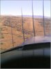
1) Final, runway 20
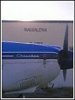
2) On the ramp
MAGDALENA QUICK FACTS:
Airport Elevation: 6727 Ft
Runways 2/20: 5650'x50ft, dirt/gravel in good condition
CTAF: 122.9
Nick's NOTAMS: No services or fuel available. No real parking or tie down spaces. Big rocks in the runway, some loose enough to like propellers.
This is, by far, the nicest gravel strip I've ever laid my eyes on. There are some pretty big rocks on the runway, but they're easy enough to navigate around. There is no tie down space, per se, but there are 2 hangars and a small terminal building that was locked when I arrived, and a turnaround spot that served as the ramp for me when I got here.
As you approach the airport from the northeast, you'll cross over the city of Magdalena itself, and you can't miss the mountain with the giant "M" on it. I assume the high school seniors must have put that up. The dirt strip is a bit difficult to pick out as there is a lot of dirt roads in this area, but remember the 2 keys to finding a dirt strip in New Mexico: Find a windsock or find a turnaround spot. N29 has both, thankfully.
The airport is located just under the CATO MOA, but its way under, as the CATO MOA starts at 13,500ft. To the west of the airport is the Very Large Array, or VLA, which is a sight that anyone who flies in this area should see. Its amazing just how big the VLA really is.
Other than the VLA or the city of Magdalena, there's not much to do here. There's a lot of cool looking prarie for those of you that like to hike, but this is rattlesnake country, so be careful. There's no fuel, and no services, and from the looks of it, most often no people here either.
Pictures (from the cellphone):
1) Final, runway 20
2) On the ramp
MAGDALENA QUICK FACTS:
Airport Elevation: 6727 Ft
Runways 2/20: 5650'x50ft, dirt/gravel in good condition
CTAF: 122.9
Nick's NOTAMS: No services or fuel available. No real parking or tie down spaces. Big rocks in the runway, some loose enough to like propellers.