SkyHog
Touchdown! Greaser!
- Joined
- Feb 23, 2005
- Messages
- 18,431
- Location
- Castle Rock, CO
- Display Name
Display name:
Everything Offends Me
Questa Municipal Airport Number 2 (N24)
Where is number 1? Its a mystery, at least it is to me. Questa Municipal Airport Number 2 is the first airport just inside the New Mexico state line when coming from the La Veta pass downward. Its a bit hard to find, since it is tucked behind a giant hill called Ute Peak, which lies between the airport and V83, the victor airway that connects Alamosa with Taos.
A stunning picture of beauty, this airport lies about 6 miles north of the city of Questa, NM. To the east of the airport lies the most gorgeous mountains in New Mexico, the Latir Peak, beyond which lies Red River, NM, another of the most gorgeous ares in the state. To the South East is Wheeler Peak, the highest mountain peak in New Mexico at 13161 ft. A road leads from the ramp to the city of Questa, but I suspect you'll be hard pressed to find people wanting to fly into this airport to see the city of Questa.
The mountains are maybe 5 statue miles to the east, which may be too far to walk, but for someone with a bike, definitely within reach. There are many places to hike in these mountains, but be careful, I didn't observe any actual designated paths, so you may be in for some rough areas to hike in.
To the east, over the Latir Peak is a desginated wilderness area, requesting at least 2000 ft AGL when flying over (if anyone actually were to fly over it, that is. Its a bit hard to get over that 12734 ft peak). The area is so gorgeous, its amazing that more houses haven't been developed here yet. Lets hope it stays that way!
The runway is in excellent condition. Someone takes great care of this airport for sure. There are no obstuctions on the approach path at all that I could see. There are no taxiways, so be prepared for a long backtaxi to runway 17 if the winds are coming out of the south. On this day, luckily, the winds were out of the north, so landing on 35 and exiting at the ramp about 1000 feet down the runway was a piece of cake.
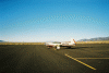
When taxiing to the ramp, be careful. The centerline of the short strip of taxiway between the runway and ramp brings low wing airplanes precariously close to wooden poles that support the chain around the ramp. I stayed a little to the left and had plenty of room on either side of my airplane. A cool looking plane, a Mooney M20F I believe, was parked on the ramp, tied down to the only tie downs available, so be prepared to bring something to secure your airplane.
Airnav.com reports that there are an average of 21 operations into and out of this airport every year. Thats a shame. This airport and the scenery around it is too amazing to not visit often. I know I'll be coming back. This would be a good place to bring a date.
QUESTA MUNICIPAL 2 QUICK FACTS:
Airport Elevation: 7700 Ft
Runways 17/35: 6861'x75ft, Asphalt in Amazingly Great Condition
CTAF: 122.9
Nick's NOTAMS: Only one set of tie down available, may be taken when you arrive. Beware of wooden poles to the right of the strip of taxiway to the ramp. NO FUEL AVAILABLE.
PHOTOS:
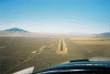
1) Approach to runway 35, notice the road leading from the ramp.
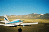
2) Latir Peak and the Latir Peak Wilderness Area
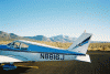
3) Wheeler Peak
4) The only tiedowns, taken by this airplane. Looks like a cool plane.
Where is number 1? Its a mystery, at least it is to me. Questa Municipal Airport Number 2 is the first airport just inside the New Mexico state line when coming from the La Veta pass downward. Its a bit hard to find, since it is tucked behind a giant hill called Ute Peak, which lies between the airport and V83, the victor airway that connects Alamosa with Taos.
A stunning picture of beauty, this airport lies about 6 miles north of the city of Questa, NM. To the east of the airport lies the most gorgeous mountains in New Mexico, the Latir Peak, beyond which lies Red River, NM, another of the most gorgeous ares in the state. To the South East is Wheeler Peak, the highest mountain peak in New Mexico at 13161 ft. A road leads from the ramp to the city of Questa, but I suspect you'll be hard pressed to find people wanting to fly into this airport to see the city of Questa.
The mountains are maybe 5 statue miles to the east, which may be too far to walk, but for someone with a bike, definitely within reach. There are many places to hike in these mountains, but be careful, I didn't observe any actual designated paths, so you may be in for some rough areas to hike in.
To the east, over the Latir Peak is a desginated wilderness area, requesting at least 2000 ft AGL when flying over (if anyone actually were to fly over it, that is. Its a bit hard to get over that 12734 ft peak). The area is so gorgeous, its amazing that more houses haven't been developed here yet. Lets hope it stays that way!
The runway is in excellent condition. Someone takes great care of this airport for sure. There are no obstuctions on the approach path at all that I could see. There are no taxiways, so be prepared for a long backtaxi to runway 17 if the winds are coming out of the south. On this day, luckily, the winds were out of the north, so landing on 35 and exiting at the ramp about 1000 feet down the runway was a piece of cake.
When taxiing to the ramp, be careful. The centerline of the short strip of taxiway between the runway and ramp brings low wing airplanes precariously close to wooden poles that support the chain around the ramp. I stayed a little to the left and had plenty of room on either side of my airplane. A cool looking plane, a Mooney M20F I believe, was parked on the ramp, tied down to the only tie downs available, so be prepared to bring something to secure your airplane.
Airnav.com reports that there are an average of 21 operations into and out of this airport every year. Thats a shame. This airport and the scenery around it is too amazing to not visit often. I know I'll be coming back. This would be a good place to bring a date.
QUESTA MUNICIPAL 2 QUICK FACTS:
Airport Elevation: 7700 Ft
Runways 17/35: 6861'x75ft, Asphalt in Amazingly Great Condition
CTAF: 122.9
Nick's NOTAMS: Only one set of tie down available, may be taken when you arrive. Beware of wooden poles to the right of the strip of taxiway to the ramp. NO FUEL AVAILABLE.
PHOTOS:
1) Approach to runway 35, notice the road leading from the ramp.
2) Latir Peak and the Latir Peak Wilderness Area
3) Wheeler Peak
4) The only tiedowns, taken by this airplane. Looks like a cool plane.
Attachments
Last edited:


