Troy,
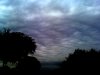
I got a chance to look at this a bit more. I think the cloud feature you observed could best be classified as a type of "Altocumulus Undulatus". They are formed as a layer of moisture interacts with rising motion and the vertical wind shear I mentioned in an earlier post.
The wind shear I discussed was likely responsible for the arrangement of the clouds into the bands. When you get instability in a layer with vertical wind shear, you'll often get small-scale vertical eddies that create clouds if the relative humidity is high in the layer. The eddies become aligned by the wind shear (often parallel with the wind shear) which in time may result in well-defined bands of cloud like those in your image. In this case, there wasn't a lot of instability below the clouds and the winds were relatively light, so the turbulence was minimal (if any).
This page has a pretty good explanation, but the example picture looks a bit different than the one you posted.
There was some rain falling from these clouds, but the sub-cloud layer was extremly dry (as you can see below from the RUC analysis) and most of the raindrops evaporated before reaching the ground creating virga (harmless) especially throughout the morning. It wasn't until the air saturated a bit more later in the afternoon that a few sprinkles developed around the metroplex between 4 and 5 pm.
You can see from this analysis at 1900 UTC, the winds at the bases of the clouds (8,500 feet) are from the east-southeast (about the orientation of the crests) and they shift around to a southerly flow just above the tops at 9,500 feet.
Hope this makes sense and helps explain the clouds.