Do pilots still navigate?

He's Jerry Wagner's biggest fan and defendant. That's what you're working with, you're wasting your time.

Lol. Jerry was the biggest anti-GPS luddite...until he learned to use one.
 
That’s all well and good. What about a GPS black out? It won’t matter how many gadgets you have. A few old charts for your route within reach could make the difference. It happens.

That doesn’t really apply either. Sure a blackout would render GPS navigation useless, but charts and approach plates are still going to be easily accessible on ForeFlight, Garmin Pilot, etc.. As a couple of others have pointed out flying with a backup tablet and a phone plus some extra power sources pretty much ensures safe and reliable access to electronic charts. In the early days of ForeFlight, I kept my paper chart subscription for until I realized how pointless it was with quadruple redundancy of a G1000, tablet, backup tablet, and phone. Throw in a Stratus or simular device, there’s an additional GPS receiver, AHRS, and ADS-B weather if your electrical system decides to depart unexpectedly.
 
Last edited:
Stop using the vacuum radio powered by a wet vacuum pump and use modern solid state electronics and failure rate will dramatically decrease.
In reality, there are very limited reasons for modern electronics to fail. Heat, power, and software bug are the three most common. For the first, power off and let it cool off, or lower cabin temp. Second, you have backup sources right? Three, reboot.

At the end of day, old avionics have actually much higher failure rates than modern solid state ones do. The issue is that the old ones are known, with these new fangled things are scary when they fail because I just spent $$$$ and do not understand why it failed.

This largely is a known risk verses the unknown. Human nature prefers the known risk even if much higher than the unknown.

Tim


Sent from my HD1907 using Tapatalk

If there are any vacuum tube radios being depended upon in today’s aviation, I would be shocked. What do you know about vacuum tubes anyway? I fully expect that there are more wiring and cabling type failures than there are “solid state” (an antiquated term that went out when integrated circuits came in by the way) failures.

For those who care not for redundant systems, even if some of them are paper, go for it. For me it is nothing to have a few paper charts and approach plates within reach. What’s the harm? I hope you are not in an immediately dire situation when you’re waiting for that gadget to cool off.
 
Sometime some of you guys should look at old accident reports. Go ahead, might be edumacational. Used to be a percentage of airplane accidents were people getting lost, running out of gas. and crashing. Happened regularly. Wasn't the most common cause of accidents, but it happened. Pilotage is great until you hose it up. You don't really see those sorts of accidents anymore.
 
Flying to familiar places on weekends I sometimes just fly a compass heading....flying 30 miles or so with few outstanding landmarks ....all chicken houses look alike....is good practice...although this is not the same as going on a long cross country.

Some of us fly antique classic airplanes with wet vacuum pumps...they are reliable. I even know a few pilots who have tube radios ...mostly for keeping the panel nostalgic.

I would have to admit most pilots do not navigate these days...we are a slave to gps. I am certainly guilty.
 
That doesn’t really apply either. Sure a blackout would render GPS navigation useless, but charts and approach plates are still going to be easily accessible on ForeFlight, Garmin Pilot, etc.. As a couple of others have pointed out flying with a backup tablet and a phone plus some extra power sources pretty much ensures safe and reliable access to electronic charts. In the early days of ForeFlight, I kept my paper chart subscription for until I realized how pointless it was with quadruple redundancy of a G1000, tablet, backup tablet, and phone. Throw in a Stratus or simular device, there’s an additional GPS receiver, AHRS, and ADS-B weather if your electrical system decides to depart unexpectedly.

You know, apparently from my comments about pitching paper charts and plates within reach, I think people are getting the idea that I reject modern navigational tools. Nothing could be further from the truth. My Mooney has 430W, JPI, 345, an iPhone on the yoke and FF on my lap with ADS-B IN/OUT on the 430, the phone and the pad. My Little Cessna has ILS capability, an ADS-B IN/OUT transponder, a phone on the yoke, a Pad in my lap and will have a 420 in the panel before I fly it again this week. Does that sound like someone who denies the value of current technology?

I am retired from a career in electronics and automation system development. The automation world is filled with redundant systems. My mentality, when it comes to control systems and other mission critical instrumentation and controls, is all about redundancy. Even on a control system with programmable controllers and computer based control systems to the max, there is still an old fashioned red mushroom emergency stop switch to interrupt power and shut everything down immediately. There are also paper based procedures for various emergency situations.

So why am I such a villain because I choose to take a “just in case” approach?
 
The thread title should have been ... "Are you a child of the Magenta?"

Guess that's why the 172-N on the field (one kx155, ASDS-B Squawk box, and intercom) sits there. No GPS, no magenta line, no glass AI. Strictly VFR. Ratty paint. Engine has 300 hrs (it is an STC'd mill to replace the H engine). Flies a lot better than it looks, but the students want the blinking lights etc. While my plane is down, this sad old N model 172 is almost available at my beck and call for short attitude-adjustment or hamburger runs on a moment's notice.

Now, I'm not a luddite. I'm updating my own plane to G5s, GFC-500 driven from an up to date database in my 430W, KY197/KN53 as my second nav/comm, ADS-B transponder, Stratux, Foreflight, etc all in the front office. But, there is a certain mindset (call it visualization, imaging, what have you) that you need to develop, on the ground, in the comfort of your planning desk or flight school conference table, that will allow you to visualize "The Big Picture" (tm) you just can't get from pushing buttons in the cockpit. The ergonomics of the devices was built to enable task execution, not planning or spitballing. Two completely different focus areas.

I've trained folks in planes with the latest and greatest toys in the panel during their primary training. But I insisted that before we launched off into their XC training, they invested in the sectional, pull out the plotter that was in their kit, and their calculator (I use a whiz wheel to prove a point...) and we work out, calmly on the conference table, some xc routes, do the true course to compass heading stuff...wind triangles, weather, etc.

To a person, while they admit after earning their ticket, that there is a lot of direct to -> enter -> enter for local flights...they understand what all the calculations are, airspace is, and xc based on a pencil line on a chart and feel more confident with their ability to actually end up on the course going to where they planned to go. Besides...sitting in their comfy chair at home...a lot easier to explore a sectional to get the "Big Picture" (tm) at a glance. But I still like my iPad in the front cabin when unfolding a sectional would take up most of the front seats....lol.

Hey I like the magenta line. But I also like looking out the window, too...;)
 
Sometime some of you guys should look at old accident reports. Go ahead, might be edumacational. Used to be a percentage of airplane accidents were people getting lost, running out of gas. and crashing. Happened regularly. Wasn't the most common cause of accidents, but it happened. Pilotage is great until you hose it up. You don't really see those sorts of accidents anymore.

The running out of gas and crashing hasn't gone away. Pretty sure that pilotage didn't play a factor in most of those as it is. Even pilotage is pretty hard to get lost if you know what you are doing. Even my major trip out west 4200+ nm over 12 days was done via pilotage because of the terrain and the lack of airports at places I wanted to see. All my students are required to use pilotage (turn off location and gps on the tablet now) before the check ride is signed off for, and none of them have crashed. It's unwise to project your flying/navigation skill shortcomings on to others. Not everyone has the same (lack of) skillset as the next person.
 
Like I said Ed, it works great until you hose it up, and pilots hose it up lots. Always have.
 
Like I said Ed, it works great until you hose it up, and pilots hose it up lots. Always have.

Same with landings. And takeoffs. And everything else. Maybe we should skip the landings and take offs too because someone might screw them up sometime?
 
I use the paper charts all the time....

As a sun shade when the plane is sitting on the ramp.
 
Mount Tamalpais, Mount Diablo, The Bay, the Sierras... Where I fly it's hard to get very lost, even with no charts or magenta lines.

I'm sure there are areas of Kansas and Missouri and surrounding states where you might as well be in the middle of the Pacific Ocean nav wise.
 
@MBDiagMan

I was being cheeky. :)
As for vacuum tubes, my younger brother is an audiophile. Until I moved in 2012, my main audio amplifier was based on vacuum tubes. Sounded great.
Yes, I know the difference between integrated circuits and solid state. My point was solid state MEMS chips have replaced most of the mechanical spiny things, and have a much lower failure rate.

Tim
 
Same with landings. And takeoffs. And everything else. Maybe we should skip the landings and take offs too because someone might screw them up sometime?
This is a simple thing Ed. So simple even you can get it. Used to be lots of guys crashed because they got lost. In lots of places everything looks the same from the air. I kinda live in one. In the age of GPS those accidents have all but disappeared. You can say "well, had they done everything right they would have all been fine". Some of those flights were instructional.

Do what you like, I honestly don't care. But that's the data.

Do you have the data to back this up?
Getting lost doesn't cause a crash, unless you're a female pilot out over the Pacific Ocean.

I've flown in your area many times. It does NOT all look the same.
 
He's Jerry Wagner's biggest fan and defendant. That's what you're working with, you're wasting your time.
Don’t start with the personal attacks. There are plenty that can be thrown in all directions.
 
You know, apparently from my comments about pitching paper charts and plates within reach, I think people are getting the idea that I reject modern navigational tools. Nothing could be further from the truth. My Mooney has 430W, JPI, 345, an iPhone on the yoke and FF on my lap with ADS-B IN/OUT on the 430, the phone and the pad. My Little Cessna has ILS capability, an ADS-B IN/OUT transponder, a phone on the yoke, a Pad in my lap and will have a 420 in the panel before I fly it again this week. Does that sound like someone who denies the value of current technology?

I am retired from a career in electronics and automation system development. The automation world is filled with redundant systems. My mentality, when it comes to control systems and other mission critical instrumentation and controls, is all about redundancy. Even on a control system with programmable controllers and computer based control systems to the max, there is still an old fashioned red mushroom emergency stop switch to interrupt power and shut everything down immediately. There are also paper based procedures for various emergency situations.

So why am I such a villain because I choose to take a “just in case” approach?

Didn't intend to villainize, just a differing viewpoint. I'd argue that most pilots have personal rituals that provide some comfort and help manage fears of encountering a chain of failures. Carrying a paper chart could be seen as less compulsive and more cost effective (and lighter) than 3 extra electronic devices plus batteries.
 
When I learned it was paper, plotter and E6B. Now I use my tablet with my phone as a backup and paper (outdated) as backup to that. I could easily pull out the map at any given time and navigate.
 
Do people go to AAA anymore and get paper street maps?...no, but they are still navigating.

I did just last year. Hadn't been to AAA in years, but we were planning a two-week cross-country drive, and figured the maps were a good way to have big-picture, what-is-nearby-that-might-be-of-interest info to supplement what we were getting from the GPS.

I don't think they do TripTiks anymore, though. :)
 
I've been known to point in a general direction, then fly said direction. although I don't see that method documented in any official FAA docs, could that still be considered navigating?
 
....and I hope that neither of us ever find a paper sectional necessary, but there could be a time when you would really like to have one handy.

I hope not too! Not trying to be funny with this comment, but I have been in more than one BC survival discussion in the past where a sectional is brought up in the context of starting a fire. OK, maybe there was a little humor in that, but the discussions and context were true and serious...

Again, my thoughts are if you want to carry a sectional on flights, by all means carry one...
 
I may have mentioned before I was a bit of a scofflaw in my younger days.

I needed to prove I was a student to get a discount on an Icelandic Airways flight to Europe. I wasn’t, so I made my own ID. This was before home computers, so I used the emblem from a Pickett slide rule manual for my fake university.
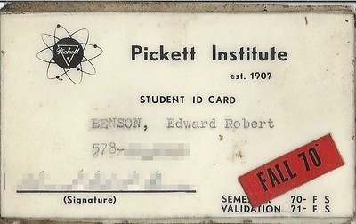
16230675346_1ea8688aa9_w.jpg


And it worked!
I’d have “liked” the post, but I can’t condone that behavior.:eek:

nice job on the ID, though.:cool:
 
Do people go to AAA anymore and get paper street maps?...no, but they are still navigating.
Does AAA (or anybody else, for that matter) have street maps anymore? I haven’t been able to find them. If I could find them, I’d use them.
 
Does AAA (or anybody else, for that matter) have street maps anymore? I haven’t been able to find them. If I could find them, I’d use them.
AAA still has street maps. Tour books, too (the paperbacks with hotel and restaurant listings and points of interest for each state).
 
RE: Children of the magenta line

...I find the term to be somewhat pejorative...

I've watched the 25 minute video numerous times.. there are some good points in there. But I don't think it's fair to blame it on automation.. it should be blamed on moronic pilots who aren't flying the plane first. Magenta lines, autopilots, GPS, are there to help you. If you don't use it appropriately that's on the pilot, not the automation. I bet autopilots and GPS have saved a lot more lives than it has cost. For everyone 1 pilot who lost control due to inappropriate AP use of automation (Casey Anthony PC-12, Bucharest Airbus, Air France) there are probably a hundred who are thankful they had the tools they did when they were flying an unfamiliar night approach alone or with their family on board, or navigating weather and terrain, etc., or just found themselves in IMC by accident. The blue LVL button can be a lifesaver.


The biggest value from the video is knowing when to go up or down levels of automation. I've seen people (from the right seat) get all out of sorts trying to figure out why an AP is doing something when we're IMC.. Dude just shut it off and fly the plane first. Go on the heading and altitude ATC said. If you can't find the fix in the 430 approach plan then you probably entered it wrong or hit VTF instead of loading the whole route. Ask for a vector, or slow down.. fly straight and level, and reload the thing


Technology is not bad.. debates like this are always frustrating as it hones in on one event or some CFI giving a flight review who "just can't believe that his student used direct enter enter to get back to the airport instead of taking out his paper charts and triangulating by VOR" .. where does it stop? Why not admonish him for not busting out a sextant?

How often has your flight been foiled by a GPS outage?
How many VOR are out of service at any given time?
Do you know the status of every VOR on your route of flight?

An iPad can still be perfectly useful as a chart even without GPS signal. The changes of your battery dying or the thing overheating are in the same realm of poor planning as forgetting your chart at home, forgetting to bring an update to date one, or ripping it when you're trying to unfold it in a cramped cockpit (presumably without autopilot since AP=bad and now you're slowly falling into a death spiral while you're unfolding the map)

Ridiculous.
 
So why am I such a villain because I choose to take a “just in case” approach?
..because you came out fairly early on staunchly in the non GPS category with some strong opinions about it. Someone made an innocent comment about how they navigate and you asked if they were with their mom

I think a just in case approach is fine. You should always have an out. Always be situationally aware, and stay ahead of the plane. Having a paper chart on hand though is not the only way to do that. Personally I've had a lot more VOR outages impact me adversely than I have GPS outages. The day of my IR checkride the damn OCN VOR was not operational and it resulted in some quick thinking of a new hold and approach to fly somewhere else.

Part of this is also because people get practically no training on how to actually use a 430/530 or 650/750. They're taught one way, by a CFI requiring they do it all by hand on paper charts, and then they rent the plane on their own and instead of knowing how to enter a flight plan they end up creating user defined way points and all sorts of cockamaymie nonsense or getting themselves in trouble and people get to say "SEE, GPS is bad!!" .. it's all about the training
 
I've watched the 25 minute video numerous times.. there are some good points in there. But I don't think it's fair to blame it on automation.. it should be blamed on moronic pilots who aren't flying the plane first. Magenta lines, autopilots, GPS, are there to help you. If you don't use it appropriately that's on the pilot, not the automation.
I thought the gist of the video was that it was a pilot issue, not an automation issue.
 
The answer to the original question is: Of course we still navigate.

Of course the guys who flew with nothing but an old road map, compass and watch question whether the new pilots flying AN beacons knew how to "navigate". And those pilots would question the piloting skills of the new pilots flying with ADF's. And those fliers would shake their heads at the kids flying those VOR's. And those pilots would question the intelligence of flying from a LORAN signal generated 100's of miles away, etc.

The point is, technology evolves. If you don't adapt, you will get left behind.

Unless all you want to do is fly that Taylorcraft or Cub with no electrical system and never talk to anyone. And that's fine too.
 
OK. I admit it.
I have GPS, VOR, ILS\Localizer, Waypoint, NOAA Weather and Weather Alert on my Yaesu FTA750L.
They all work very well.
I have Avare, a couple aviation weather apps, with radar on my phone.
The only time I use any of it is if I suspect I'm in a strong headwind and I'm sweating fuel. Otherwise I just randomly point the airplane in the general direction I want to go, and sort it out looking at the map.
The Northeast is a pretty "target rich" area for landmarks with the Hudson River, Taconic Parkway, NYS Thruway and the Catskill range providing all the north\south I need. Exits off the Taconic, the Thruway, Rt84, I90 etc, etc providing east/west guidance.
The Midwest and far West are more challenging. Every cornfield looks like every other cornfield and every lump of rock looks like every other lump of rock out west.
Out there you need a roadmap to follow.
 
Worked for Lindberg! He went all the way across the Atlantic with nothing but the best compass he could put in the plane, a clock, and a carefully laid out chart. He fell asleep, iced up and circled and still was only six miles off course when he made land fall. Before that, he navigated the US with railroad maps.
Quite right, but luck probably played a big role there. He had very little info available about the upper winds, so no amount of dead-reckoning knowledge would have gotten him to an accurate landfall if the winds hadn't chosen to cooperate that night. Others before him hadn't been so lucky.
 
I have a quite nice GPS unit. I have a backup on my iPhone if needed. For those that were triggered by my "children of the magenta" note it's OK. FWIW, I do have a sectional tucked in the side pocket too ... :rockon:
 
Worked for Lindberg! He went all the way across the Atlantic with nothing but the best compass he could put in the plane, a clock, and a carefully laid out chart.

But - didn't work out for all of those others who disappeared without a trace, and others whose remains were found. Didn't work for Amelia. Those are not odds that I'm shooting for.

The "do pilots still navigate" assumes that using GPS isn't navigating. Whether you use a compass, a sextant, ADF. Loran, DME, VOR - or even GPS - is still using aids for navigation. It's just how smart do you want to be about it. You don't get brownie points for making things harder than they need to be just because that was they way it was done. Do you have electric lights in your home? Should you not only use candles and whale oil lamps because the electricity might go out?
 
I can absolutely find my way home from McDonald's without GPS or a map.

Baby steps...

LOL. Sadly I tend toward turning on the GPS on the phone in the car these days, not because I need the directions but because of the handful of times the real-time traffic data would have saved me from sitting in an accident-caused traffic jam.

That’s the real killer app of automotive GPS. Traffic based re-routing.

It’d be nice if the software was smart enough just to say “Take your usual route, it’s clear. I’ll let you know if something happens ahead.” And then it shuts the hell up. Ha.

Certainly doable since they’re all keeping your travel data.
 
RE: Children of the magenta line

...I find the term to be somewhat pejorative...

I've watched the 25 minute video numerous times.. there are some good points in there. But I don't think it's fair to blame it on automation.. it should be blamed on moronic pilots who aren't flying the plane first. Magenta lines, autopilots, GPS, are there to help you. If you don't use it appropriately that's on the pilot, not the automation. I bet autopilots and GPS have saved a lot more lives than it has cost. For everyone 1 pilot who lost control due to inappropriate AP use of automation (Casey Anthony PC-12, Bucharest Airbus, Air France) there are probably a hundred who are thankful they had the tools they did when they were flying an unfamiliar night approach alone or with their family on board, or navigating weather and terrain, etc., or just found themselves in IMC by accident. The blue LVL button can be a lifesaver.


The biggest value from the video is knowing when to go up or down levels of automation. I've seen people (from the right seat) get all out of sorts trying to figure out why an AP is doing something when we're IMC.. Dude just shut it off and fly the plane first. Go on the heading and altitude ATC said. If you can't find the fix in the 430 approach plan then you probably entered it wrong or hit VTF instead of loading the whole route. Ask for a vector, or slow down.. fly straight and level, and reload the thing


Technology is not bad.. debates like this are always frustrating as it hones in on one event or some CFI giving a flight review who "just can't believe that his student used direct enter enter to get back to the airport instead of taking out his paper charts and triangulating by VOR" .. where does it stop? Why not admonish him for not busting out a sextant?

How often has your flight been foiled by a GPS outage?
How many VOR are out of service at any given time?
Do you know the status of every VOR on your route of flight?

An iPad can still be perfectly useful as a chart even without GPS signal. The changes of your battery dying or the thing overheating are in the same realm of poor planning as forgetting your chart at home, forgetting to bring an update to date one, or ripping it when you're trying to unfold it in a cramped cockpit (presumably without autopilot since AP=bad and now you're slowly falling into a death spiral while you're unfolding the map)

Ridiculous.
Agreed.
We've all heard the news stories of people in cars that followed their GPS onto a train track or the wrong way down a one-way street.
You can't blame the technology for that.
 
LOL. Sadly I tend toward turning on the GPS on the phone in the car these days, not because I need the directions but because of the handful of times the real-time traffic data would have saved me from sitting in an accident-caused traffic jam.

That’s the real killer app of automotive GPS. Traffic based re-routing.
We were on our way to a concert. As we approached an intersection, the "road" up ahead turned red. A voice, "I have a better route. Turn left next intersection."

There was a major accident about 2 miles ahead. Time lost due to GPS rerouting, 3 minutes.
 
LOL. Sadly I tend toward turning on the GPS on the phone in the car these days, not because I need the directions but because of the handful of times the real-time traffic data would have saved me from sitting in an accident-caused traffic jam.
Same here, although I found that Waze was too anal about saving 1 minute, and would use some really strange routings through neighborhoods. Now I stick to either Apple Maps or Google Maps.
 
Back
Top