Palmpilot
Touchdown! Greaser!
I was at 3,500 when they said it. (I don't remember whether they prefaced it with "climb and.")Confused. If you were VFR and they said "Maintain 4000" what were you doing at an IFR altitude in the first place?
I was at 3,500 when they said it. (I don't remember whether they prefaced it with "climb and.")Confused. If you were VFR and they said "Maintain 4000" what were you doing at an IFR altitude in the first place?
Unless ATC assigns - instructs you to fly - a specific altitude, the hemispheric rule applies. You are receiving advisory service, not control.Here's a different question, based on the phrase in the FAR "unless otherwise authorized by ATC".
Let's say you're with ATC using VFR FF on a course of 010 and 9500.
You hit a waypoint and turn left to your new course of 345.
Do you change to 8500/10500, or stay at 9500?
Does ATC accepting your initial altitude of 9500 mean you are "authorized" to stay there?
Do they expect you to change altitude at your waypoint?
There are no "wrong" ATC altitudes. The Part 91 VFR rule applies unless ATC says otherwise. The Part 91 IFR rule only applies to uncontrolled airspace. ATC has its own version of the rule but it is changeable based in traffic considerations.Man, your instructor would have his head explode flying IFR, or even sometimes VFR with FF, in SoCal's airspace. They love wrong way altitudes, especially between 5000 and 7000, to assist separation from departure corridors.
Quite correct. No question.Still pretty sure if ATC instructs me: “N467SA, radar contact, maintain at or above 4,000’ ref crossing traffic until further advised”, that must by law be adhered to unless an emergency is declared.
4-4-9. ADHERENCE TO CLEARANCE
a. When air traffic clearance has been obtained under either visual or instrument flight rules, the pilot-in-command of the aircraft shall not deviate from the provisions thereof unless an amended clearance is obtained. When ATC issues a clearance or instruction, pilots are expected to execute its provisions upon receipt.
(Bolded mine.)
Still pretty sure if ATC instructs me: “N467SA, radar contact, maintain at or above 4,000’ ref crossing traffic until further advised”, that must by law be adhered to unless an emergency is declared.
4-4-9. ADHERENCE TO CLEARANCE
a. When air traffic clearance has been obtained under either visual or instrument flight rules, the pilot-in-command of the aircraft shall not deviate from the provisions thereof unless an amended clearance is obtained. When ATC issues a clearance or instruction, pilots are expected to execute its provisions upon receipt.
(Bolded mine.)
")
Key to the above are the words "unless otherwise authorized by ATC".

As mentioned, there is no conflict. This is one of many rules dealing with the flow of air traffic which contains the "unless otherwise authorized by ATC" exception. The "no deviation from any rule" advisory is really targeted at other things, like VFR pilots flying into clouds. There's no "unless otherwise authorized by ATC" for that one.Good point, but there are lots of rules to consider. For example (red added for emphasis),
4-4-1. Clearance
a. A clearance issued by ATC is predicated on known traffic and known physical airport conditions. An ATC clearance means an authorization by ATC, for the purpose of preventing collision between known aircraft, for an aircraft to proceed under specified conditions within controlled airspace. IT IS NOT AUTHORIZATION FOR A PILOT TO DEVIATE FROM ANY RULE, REGULATION, OR MINIMUM ALTITUDE NOR TO CONDUCT UNSAFE OPERATION OF THE AIRCRAFT.
And the FAR says in 91.159,
§ 91.159 VFR cruising altitude or flight level.
Except while holding in a holding pattern of 2 minutes or less, or while turning, each person operating an aircraft under VFR in level cruising flight more than 3,000 feet above the surface shall maintain the appropriate altitude or flight level prescribed below, unless otherwise authorized by ATC:
(a) When operating below 18,000 feet MSL and -
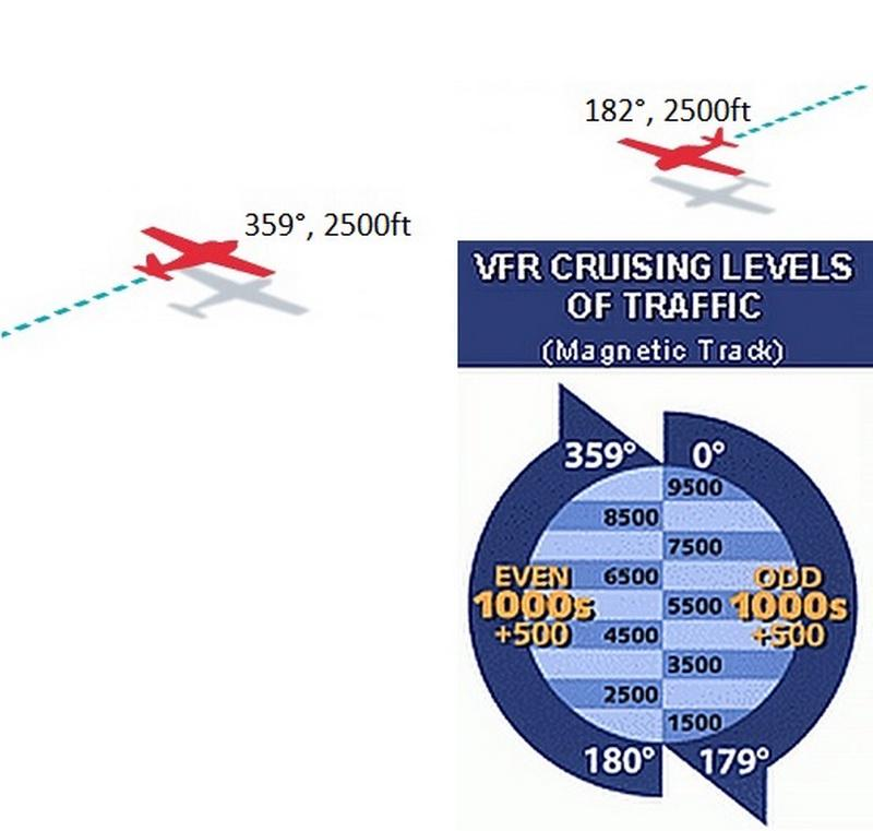
(1) On a magnetic course of zero degrees through 179 degrees, any odd thousand foot MSL altitude + 500 feet (such as 3,500, 5,500, or 7,500); or
(2) On a magnetic course of 180 degrees through 359 degrees, any even thousand foot MSL altitude + 500 feet (such as 4,500, 6,500, or 8,500).
Bearing in mind that the AIM is advisory and does not trump the FAR, if ATC gives you an altitude that conflicts with the regulatory requirement, it would seem that you have to follow the regulation. In @Palmpilot 's example, I believe he was in class E airspace.
Great time to push the transmit button and ask, "Approach, that altitude violates regulations. Are you declaring an emergency for me?"
OTOH, I am sure there's some other rule somewhere else in the FAR that deconflicts all this.
I'm starting the think that there may be a market for a HUD version of the FAR to make it easy to read the regulations while in flight....
There are no "wrong" ATC altitudes. The Part 91 VFR rule applies unless ATC says otherwise. The Part 91 IFR rule only applies to uncontrolled airspace. ATC has its own version of the rule but it is changeable based in traffic considerations.
You need a new CFI right away!Did a little ground school work with my new CFI regarding navigation, and I asked about how one determines their correct VFR altitude, as in the odd thousand + 500, or even thousand + 500 thing. My understanding was that it's determined by the course you're flying, and NOT on the heading of the plane. In other words, even if you have to point the plane eastward due to the wind, if the plane is overall moving westward, then you'd do even thousand + 500 feet.
He then tells me "no", and you go by whatever the heading of the plane is based on what the compass is telling you. I thought I was misunderstanding him, so I then asked "So, whatever my compass is reading, I go by that in order to determine my correct VFR altitude, no matter how I'm tracking across the ground? In other words, I go by the heading of the plane, and not the course?". To this he said "Yes, you strictly go by where the plane is pointed".
This goes against the FAR, which in a nutshell says this:
(1) On a magnetic course of zero degrees through 179 degrees, any odd thousand foot MSL altitude +500 feet (such as 3,500, 5,500, or 7,500); or
(2) On a magnetic course of 180 degrees through 359 degrees, any even thousand foot MSL altitude +500 feet (such as 4,500, 6,500, or 8,500).
It deinitely says "magnetic COURSE", NOT "magnetic HEADING"!
I couldn't find the definition of magnetic course anywhere in the FAR, but a Google search says:
"Magnetic Course is the airplane’s course across the ground, relative to magnetic north."
This to me makes sense. I'm also thinking that the ATC people watching you on their radar are expecting you to be at the proper VFR altitude based on how you are tracking across the ground. So, if they see you tracking at say 355 degrees magnetically, they consider you going west, and thus expect even thousand + 500. They couldn't care less about where your plane is pointing.
My instructor also said that you never need to compute magnetic course.
The one odd thing with this though is that if I'm right, in that you base your VFR altitude on your magnetic course, then why is it not computed when filling out the VFR Navigation log? In that, it's all about headings.
Aren't CFI's douchebags by definition?it's definitely not something to switch CFI's over unless he's a douchebag about it.
Confused. If you were VFR and they said "Maintain 4000" what were you doing at an IFR altitude in the first place?
I was over Livermore Valley, which is 400-ish.4000' could very well be below the 3000' hemi rule. You know in places where the elevation in the state is more than 300' MSL.
I interviewed in Pleasanton a few years back. That's in or under the Bravo is it not?I was over Livermore Valley, which is 400-ish.
I interviewed in Pleasanton a few years back. That's in or under the Bravo is it not?
no. pilots are.Aren't CFI's douchebags by definition?
On number one, yes, you still turn right. The point is to be predictable, and to keep the other plane in your view. If one sees and turns right and the other does not see, you’re fine. If one decides to turn left and the other right, what does your picture look like? Not good. If you turn left, you also lose sight of the other plane faster.The Rules state… “When two aircraft are approaching head-on or approximately so, both should yield to the right.”
But what if they’re slightly off to the right of each other? Is it still a good idea to turn right?
How to deal with a situation when you need to fly directly southbound (180° mag track) or northbound (360°)? It’s impossible to keep a constant track of 360/180° and you will be off-course by +/-1° anyway flying in that direction.
You fly the appropriate altitude for your course, not your heading.anyway, you've got the idea;
The second question is about which FL do you need to stick with when you have to fly directly south or north, because you you will be off by a couple degrees anyway.
If the aircraft are off to the right of each other, they're not approaching each other head-on or approximately so; they're not approaching each other at all. You're quoting a right-of-way rule. It only applies when it's necessary for one or more aircraft to give way. In your scenario, neither aircraft need alter course and they'll each continue on their merry way.The Rules state… “When two aircraft are approaching head-on or approximately so, both should yield to the right.”
But what if they’re slightly off to the right of each other? Is it still a good idea to turn right?
The second question is about which FL do you need to stick with when you have to fly directly south or north,
If the aircraft are off to the right of each other, they're not approaching each other head-on or approximately so; they're not approaching each other at all. You're quoting a right-of-way rule. It only applies when it's necessary for one or more aircraft to give way. In your scenario, neither aircraft need alter course and they'll each continue on their merry way.
But what if the other pilot will not see you? You will be flying directly into the path of the second plane. Which would be stupid as hell.
Yes it would. If you're going to pass on the left, just keep going. If you're not, turn right until you are no longer in the path of the second plane.But what if the other pilot will not see you? You will be flying directly into the path of the second plane. Which would be stupid as hell.
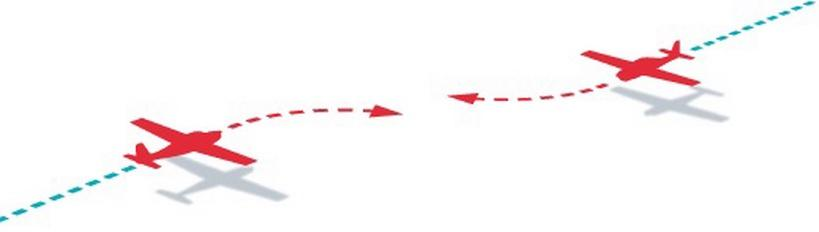
Then they each sidestep right, and if they haven't waited until the very last moment when they were going to crash anyway, all is well.Well there is convergence, 359 vs 182. And based on the picture, even if it was exactly parallel, extrapolate out and they are less than a wing span apart.
The good news is, as long as you see him, you can avoid.But what if the other pilot will not see you? You will be flying directly into the path of the second plane. Which would be stupid as hell.
While the right-of-way rules are nice in an academic sense, I can only see them being routinely useful maybe in seaplane taxiing at a crowded seaplane base (the right-of-way rules, of course, being developed from boating rules). In 28 years of flying I don't think I have ever once had a situation where the right-of-way rules needed to be applied. In any close situation, there is always some other factor that makes the avoidance maneuver obvious - one plane is a little higher than the other, they're not actually going to collide anyway, etc. Even at busy uncontrolled airports or fly-ins and such, where you'd think the rules might come into play, generally everybody's at least moving the same direction and it becomes a matter of just being smart working it out on the radio - "you go first, I'll follow you".
I'm guessing your instructor just flipped a bit, mentally. They would have learned initially that altitude for direction of flight is based on magnetic rather than true directions, then along the way somehow muddled that up with heading vs track.Did a little ground school work with my new CFI regarding navigation, and I asked about how one determines their correct VFR altitude, as in the odd thousand + 500, or even thousand + 500 thing. My understanding was that it's determined by the course you're flying, and NOT on the heading of the plane. In other words, even if you have to point the plane eastward due to the wind, if the plane is overall moving westward, then you'd do even thousand + 500 feet.
He then tells me "no", and you go by whatever the heading of the plane is based on what the compass is telling you. I thought I was misunderstanding him, so I then asked "So, whatever my compass is reading, I go by that in order to determine my correct VFR altitude, no matter how I'm tracking across the ground? In other words, I go by the heading of the plane, and not the course?". To this he said "Yes, you strictly go by where the plane is pointed".
This goes against the FAR, which in a nutshell says this:
(1) On a magnetic course of zero degrees through 179 degrees, any odd thousand foot MSL altitude +500 feet (such as 3,500, 5,500, or 7,500); or
(2) On a magnetic course of 180 degrees through 359 degrees, any even thousand foot MSL altitude +500 feet (such as 4,500, 6,500, or 8,500).
It deinitely says "magnetic COURSE", NOT "magnetic HEADING"!
I couldn't find the definition of magnetic course anywhere in the FAR, but a Google search says:
"Magnetic Course is the airplane’s course across the ground, relative to magnetic north."
This to me makes sense. I'm also thinking that the ATC people watching you on their radar are expecting you to be at the proper VFR altitude based on how you are tracking across the ground. So, if they see you tracking at say 355 degrees magnetically, they consider you going west, and thus expect even thousand + 500. They couldn't care less about where your plane is pointing.
My instructor also said that you never need to compute magnetic course.
The one odd thing with this though is that if I'm right, in that you base your VFR altitude on your magnetic course, then why is it not computed when filling out the VFR Navigation log? In that, it's all about headings.