Scott MacKie
Pre-Flight
Without me digging up a map or foreflight, is there a sane way to do this? I-40? I-20?
T'anks.
T'anks.
How can we possibly say whether the trip is a good idea if we don’t see the airplane first?What the? How could there be a picture of a flight that is in it's imaginary state?
How can we possibly say whether the trip is a good idea if we don’t see the airplane first?
I've actually been watching the route from KLVK to KTOC everyday for the last few months and tracking if route was clear for VFR that day. I tend to plan on ~I-5 to ~I-40, but with some deviations for weather. The personal mins I applied were stable <3k ceilings for VFR and <6sm vis. ICE is anything that would require flying through clouds that might be near the danger zone.Without me digging up a map or foreflight, is there a sane way to do this? I-40? I-20?
T'anks.
The weather looks pretty good today, not so great tomorrow. So yes, it's doable.
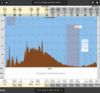
I approximated the route as Los Angeles - Lordsburg NM - El Paso - Atlanta. Roughly speaking, it's I10 from Los Angeles to El Paso, then direct to Georgia. Here's the route view for today, in WeatherSpork.com.
View attachment 92759
Something like this. And, way better CA to GA than westbound!Totally reasonable if you have lots of time. Time for delays and hotel rooms waiting for good weather days...
Send it.

I'm beginning to question @Scott MacKie's motivation.
Are you ferrying this?
I'll be surprised if most of the advice is other than go South first and then go across I-10ish or I-20ish. Not just for altitude, but for weather. You mentioned Flagstaff, but there's plenty of high cold places along I-40 until you get through New Mexico and then there are low cold places.
It's certainly a good idea, but in all the times I've flown coast to coast or VA to Phoenix, I I have only taken the southern route maybe 25% of the time. One reason is the damn wind. Most of the time I've flight planned that route, particularly in the winter, winds in southwestern Texas were blowing 20-30 kts and often cross-wind. Not always the best thing in a taildragger.I'll be surprised if most of the advice is other than go South first and then go across I-10ish or I-20ish. Not just for altitude, but for weather. You mentioned Flagstaff, but there's plenty of high cold places along I-40 until you get through New Mexico and then there are low cold places.
It's certainly a good idea, but in all the times I've flown coast to coast or VA to Phoenix, I I have only taken the southern route maybe 25% of the time. One reason is the damn wind. Most of the time I've flight planned that route, particularly in the winter, winds in southwestern Texas were blowing 20-30 kts and often cross-wind. Not always the best thing in a taildragger.
When I flew my 170 out to Virginia from San Diego, my route was San Diego to Mesa, AZ. Mesa to Albuquerque, then Albuquerque across northern TX to Birmingham, AL and then home to Virginia.
For the OP, following I-40 should work fine to get to ABQ/SAF area and then onward should work fine. Just have 2 to 3 routes planned in order to be flexible for weather.[/QUOTE
I'm diggin' on the I-40 route. Highest spot is Flagstaff, some wiggles over western NM (Grant) then into ABQ, then through Tijeras pass or south of the Manzon's and you're home free. Winds excepted of course.
It's certainly a good idea, but in all the times I've flown coast to coast or VA to Phoenix, I I have only taken the southern route maybe 25% of the time. One reason is the damn wind. Most of the time I've flight planned that route, particularly in the winter, winds in southwestern Texas were blowing 20-30 kts and often cross-wind. Not always the best thing in a taildragger.
When I flew my 170 out to Virginia from San Diego, my route was San Diego to Mesa, AZ. Mesa to Albuquerque, then Albuquerque across northern TX to Birmingham, AL and then home to Virginia.
For the OP, following I-40 should work fine to get to ABQ/SAF area and then onward should work fine. Just have 2 to 3 routes planned in order to be flexible for weather.

I live on the VA/NC border, not much further north than GA.But..... He’s not going to Virginia. He’s going to Georgia.
WeatherSpork and/or windy.comCurious what site/app y'all are using to predict weather like that along a route. Do you mind posting them?
And a great circle route (which is shortest) goes nowhere near El Paso.
At Cessna 120 speeds that is at least an hour of extra flight time to an already long journey. Not exactly trivial, but as I mentioned, there are other issues with the southern route for a slow taildragger. Of all my trips across, I've only taken the southern route once in a tailwheel and I had long enough range on that trip to overfly El Paso.True, but only adds ~100nm, not enough to make a huge difference.