Occasionally I want to fly to a town and find the closest airport. For example Cooks Forest in Clarington (Pa). Since not all small towns are shown on the ForeFlight street map mode I find the town using MAPS. Then I do a stare and compare going back and forth between ForeFlight and MAPS until I find a major city on both near the town I want to fly to. Then zero in on the town, bring up the VFR map and find the closest airport. This is very tedious. Is there a better way to locate the nearest airport to a town in ForeFlight? If not in ForeFlight is there a better way? If possible use Cooks a Forest in Clarington (Pa) in your example. Thanks
You are using an out of date browser. It may not display this or other websites correctly.
You should upgrade or use an alternative browser.
You should upgrade or use an alternative browser.
ForeFlight: Finding an airport near a town
- Thread starter RonP
- Start date
Let'sgoflying!
Touchdown! Greaser!
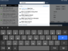
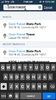
i went to Airports, typed in COOK FOREST, the state park came up.
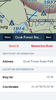
I clicked on that, it took me to maps (which I already had on sectionals)
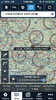
I saved the location (save button) and it looks pretty easy select an airport from there.
the link is a map image (too big for POA apparently)
dont forget the ‘ruler’ function (two fingers) which can give immediate distance between two points
https://ibb.co/6Fbzh83
I clicked on that, it took me to maps (which I already had on sectionals)
I saved the location (save button) and it looks pretty easy select an airport from there.
the link is a map image (too big for POA apparently)
dont forget the ‘ruler’ function (two fingers) which can give immediate distance between two points
https://ibb.co/6Fbzh83
Attachments
Last edited:
Let'sgoflying!
Touchdown! Greaser!
I typed in Cook Forest under Airports, got nothing useful - are you entering it elsewhere?
bluesky74656
Line Up and Wait
It works on my phone, but it shows up toward the bottom after some airport results. Maybe this is something that is dependent on your subscription level? I have Pro Plus.I typed in Cook Forest under Airports, got nothing useful - are you entering it elsewhere?
Let'sgoflying!
Touchdown! Greaser!
Brad Z
Final Approach
I usually type "airport near XYZ" in Google maps search bar. XYZ can be a city, address, business, point of interest, etc. Google maps is more appropriate than FF for this task since I need to see the road distance to the airport rather than just a straight line distance.
Cogito
Pre-takeoff checklist
Any easy way:
1) Use the maps app on your computer or iPad and find the relevant location.
2) Zoom out until you find an airport.
3) Type in the airport or airport code into ForeFlight. Might be a private airport, as in this case, but you can telephone and ask permission, or try one of the other airports nearby.


1) Use the maps app on your computer or iPad and find the relevant location.
2) Zoom out until you find an airport.
3) Type in the airport or airport code into ForeFlight. Might be a private airport, as in this case, but you can telephone and ask permission, or try one of the other airports nearby.