You are using an out of date browser. It may not display this or other websites correctly.
You should upgrade or use an alternative browser.
You should upgrade or use an alternative browser.
Paoli, Indiana runway extension
- Thread starter zaitcev
- Start date

GaryM
Pattern Altitude
Seen this picture on Facebook. U Liek?
Well, I think the prevailing winds will be for landing on 20, and this is the approach end of 2, but still, try not to overrun that runway either.
That's a lot of terraforming, considering it is such a flat state.
Jim Carpenter
Line Up and Wait
Wow. Looks like something you'd find in the Yucatan jungle. Lots of work for a pretty small town airfield. Are they going to employ a full time LSO?
WDD
Final Approach
- Joined
- Oct 16, 2019
- Messages
- 5,348
- Location
- Atlanta / KRYY
- Display Name
Display name:
Vintage Snazzy (so my adult children say)
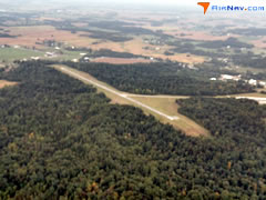
Nice Photoshop. I do know Paoli has Indiana's finest ski runs. Now, the picture would have been more believable if there was a ski run and a chair lift at the end of the runway. (Here's a picture of the actual runway if anyone is reality oriented).
Last edited:
GaryM
Pattern Altitude
Nice Photoshop. I do know Paoli has Indiana's finest ski runs.
No, that would be Terre Haute.

zaitcev
En-Route
- Joined
- Sep 30, 2010
- Messages
- 3,257
- Display Name
Display name:
Pete Zaitcev
Pretty much what a local journalist thought too:Wow. Looks like something you'd find in the Yucatan jungle.
"The runway extension would make Paoli’s airport unique by creating a 400-foot vegetated, mechanically stabilized earth wall that Dillard said would look like a pyramid in the woods. Lambert said it is already a buzzing topic in aviation circles."
What's puzzling though, the 2017 federal infrastructure grant was only $1.5 million. There's no way to move that much earth and pour concrete for the stabilizing container for that much, I think.
WDD
Final Approach
- Joined
- Oct 16, 2019
- Messages
- 5,348
- Location
- Atlanta / KRYY
- Display Name
Display name:
Vintage Snazzy (so my adult children say)
Here is an updated photo shop of the future runway in use.

timwinters
Ejection Handle Pulled
Ever been to Indiana?That's a lot of terraforming, considering it is such a flat state.
GaryM
Pattern Altitude
Ever been to Indiana?
Lived there for four years.
WDD
Final Approach
- Joined
- Oct 16, 2019
- Messages
- 5,348
- Location
- Atlanta / KRYY
- Display Name
Display name:
Vintage Snazzy (so my adult children say)
South part by the Ohio river can get a little hilly.
wrbix
Pattern Altitude
- Joined
- Jul 25, 2013
- Messages
- 2,398
- Display Name
Display name:
Pilot Lite
Grew up a Hoosier (“who’s your Daddy?”).....northern half flat....used to ride a bicycle rally around Brown County aptly named The Hilly Hundred.South part by the Ohio river can get a little hilly.
timwinters
Ejection Handle Pulled
As well as much of the state SSW of Indy...from Bloomington down thru French Lick and on south to the Ohio. Beautiful country.South part by the Ohio river can get a little hilly.
midwestpa24
En-Route
- Joined
- Mar 4, 2016
- Messages
- 4,991
- Display Name
Display name:
midwestpa24
Looking at it from an airport design/managerial standpoint, I can see the FAA funding anything like that. There is no safety area to the sides and especially the end. Look at Charleston WV. While it could be done, it'd be cheaper to move an airport that size.
zaitcev
En-Route
- Joined
- Sep 30, 2010
- Messages
- 3,257
- Display Name
Display name:
Pete Zaitcev
You do realize that the construction is almost completed, don't you?Looking at it from an airport design/managerial standpoint, I can see the FAA funding anything like that. There is no safety area to the sides and especially the end.
Capt. Geoffrey Thorpe
Touchdown! Greaser!
- Joined
- Jun 7, 2008
- Messages
- 15,626
- Location
- DXO124009
- Display Name
Display name:
Light and Sporty Guy
Don't try to confuse us with facts.You do realize that the construction is almost completed, don't you?
Todd82
Line Up and Wait
CRW was what came to mind for me too and don't forget that their built up piece they put the EMAS on collapsed during heavy rains a few years back.FAA funding anything like that. There is no safety area to the sides and especially the end. Look at Charleston WV. While it could be done
From what I hear the new extension at MGW on the south end is going to look similar to the above photo, an unofficial handshake agreement going back to WVU joining the Big 12.
I would say the northern 2/3rd. Around Martinsville is where the hills seem to start to me.Grew up a Hoosier (“who’s your Daddy?”).....northern half flat....used to ride a bicycle rally around Brown County aptly named The Hilly Hundred.