I read that the height above a private airstrip goes up to 1200 where Class E then begins. What is the horizontal distance of the Class G for such an airstrip? I am guessing that it is a 5 mile radius like a wide magenta airspace above a small airport.
You are using an out of date browser. It may not display this or other websites correctly.
You should upgrade or use an alternative browser.
You should upgrade or use an alternative browser.
Area around a private airstrip
- Thread starter Kodiak
- Start date
Capt. Geoffrey Thorpe
Touchdown! Greaser!
- Joined
- Jun 7, 2008
- Messages
- 15,626
- Location
- DXO124009
- Display Name
Display name:
Light and Sporty Guy
Class G goes up to whatever it says on the chart - most often 700 or 1200 and it goes for as far as it goes, assuming it is there at all (typically is, but I'm sure there are exceptions). The fact that there is an airport on the ground is irrelevant beyond what is shown on the charts.
If you spend some money and have someone design a private approach for your private field, you will get your own 700ft class E sector. There are a few uncharted private heliports with approaches at things like nuclear plants .
There's no controlled airspace associated with an airstrip unless there is a rulemaking to create it. The 700' transition area (or surface area) occurs only when there is an instrument approach and such rulemaking. Very few private airports have approaches, so it's unlikely to see a transition area (and certainly not a surface area). Surface areas have additional requirements (weather reporting and sufficient communications).
As pointed out, 1200' class E floor is so ubiquitous in this day that it's now the default depiction on the chart (it used to be shown by the blue vignette). It used to be that it only existed near airports with approaches and along victor airways, but things got so overlaid that it's rare NOT to have it. The 700' area is depicted by the magenta vignette.
When transition areas are created (just like surface areas), they are designed to accommodate the approach involved. I think they start at being 5 SM round but can be larger or irregularly shaped to accommodate the operational necessity.
I guess I got this confused with a public unpaved airstrip. What would be to radius of that kind of airstrip?I read that the height above a private airstrip goes up to 1200 where Class E then begins. What is the horizontal distance of the Class G for such an airstrip? I am guessing that it is a 5 mile radius like a wide magenta airspace above a small airport.
MauleSkinner
Touchdown! Greaser!
I think you’ve got something crossed up in your mind...to try and identify that, what kind of airspace are you thinking exists outside of that radius?I guess I got this confused with a public unpaved airstrip. What would be to radius of that kind of airstrip?
I went through this discussion in another post. Supposedly, this statement is wrong. Class E is everywhere, including from ground up when there is no vignette circle or other type of airport showing.Everywhere under 1200 agl is class g unless otherwise marked.
Huh? Unless there's a surface area depicted (dashed blue or magenta or sold blue or magenta rings) or a transition area (pink vignette), controlled airspace starts at 1200 feet in most of the US. Below that it is uncontrolled (class G).
Are you perhaps confused that there is uncharted communications requirements at towered fields even without controlled airspace existing?
Are you perhaps confused that there is uncharted communications requirements at towered fields even without controlled airspace existing?
I think you’ve got something crossed up in your mind...
Not a difficult thing for a student pilot.
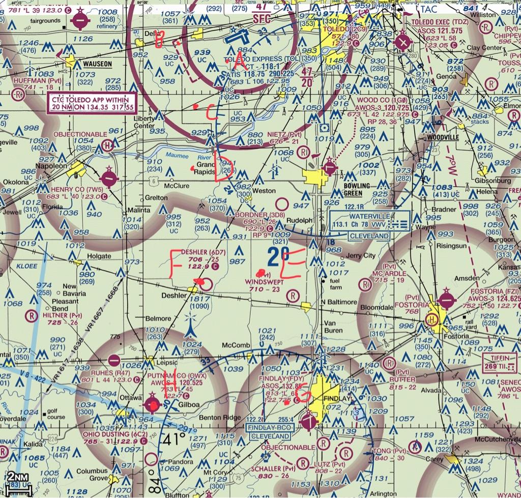
See 6D7. Supposedly the airspace above 6D7 is G up to 1200. If that is correct, what is the horizontal size?
MauleSkinner
Touchdown! Greaser!
It ends where the nearest airport has a Class E or higher surface area.Not a difficult thing for a student pilot.
See 6D7. Supposedly the airspace above 6D7 is G up to 1200. If that is correct, what is the horizontal size?
It has nothing to do with there being an airport there. The 1200' floor is everywhere that it isn't lower for some reason (with small exception). The airspace over my front yard would be class G to 1200' whether there was a runway there or not.
SkyChaser
Pattern Altitude
- Joined
- Mar 22, 2020
- Messages
- 2,019
- Display Name
Display name:
SkyChaser
Class G air space is ground to 1200' agl unless there are vignettes on the chart denoting other airspace that is lower (magenta ring for Class E down to 700', etc.).
Class E only goes to the ground where there is a dashed magenta line.
Class E is everywhere above 1200' agl that is not Class B, C or D (up to FL180, of course).
Class G is everywhere below 1200' agl that is not Class B, C, D, or E.
A runway, airstrip or airport is not required to have any controlled airspace (E, D, C or B) associated with it. The situation described in your first post is a runway without any controlled airspace associated with it. Thus, Class G goes up to 1200' agl. Horizontally, Class G airspace extends until there is another airspace designation below 1200' agl.
Does that help or answer your question?
MauleSkinner
Touchdown! Greaser!
that's not the OP's question...his question is about the horizontal distance.It has nothing to do with there being an airport there. The 1200' floor is everywhere that it isn't lower for some reason (with small exception). The airspace over my front yard would be class G to 1200' whether there was a runway there or not.
Palmpilot
Touchdown! Greaser!
That question was answered in post #2.that's not the OP's question...his question is about the horizontal distance.
MauleSkinner
Touchdown! Greaser!
and he clearly didn't understand that answer, so any vertical answers are still just confusing the issue.That question was answered in post #2.
Capt. Geoffrey Thorpe
Touchdown! Greaser!
- Joined
- Jun 7, 2008
- Messages
- 15,626
- Location
- DXO124009
- Display Name
Display name:
Light and Sporty Guy
And in 3, and 5, and 9 and 11 and kinda in 7 and 13.That question was answered in post #2.
There is no horizontal distance. (#17)
Here is what was pointed to in another post I made here:Class G air space is ground to 1200' agl unless there are vignettes on the chart denoting other airspace that is lower (magenta ring for Class E down to 700', etc.).
Class E only goes to the ground where there is a dashed magenta line.
Class E is everywhere above 1200' agl that is not Class B, C or D (up to FL180, of course).
Class G is everywhere below 1200' agl that is not Class B, C, D, or E.
A runway, airstrip or airport is not required to have any controlled airspace (E, D, C or B) associated with it. The situation described in your first post is a runway without any controlled airspace associated with it. Thus, Class G goes up to 1200' agl. Horizontally, Class G airspace extends until there is another airspace designation below 1200' agl.
Does that help or answer your question?
Class E:
https://www.faa.gov/documentLibrary/media/Order/JO_7400.11D.pdf
Generally, if the airspace is not Class A, Class B, Class C, or Class D, and it is controlled
airspace, it is Class E airspace. Class E airspace extends upward from either the surface or a
designated altitude to the overlying or adjacent controlled airspace. When designated as a
surface area, the airspace will be configured to contain all instrument procedures. Also in this
class are Federal airways, airspace beginning at either 700 or 1,200 feet above ground level used
to transition to/from the terminal or enroute environment, and enroute domestic and offshore
airspace areas designated below 18,000 feet MSL. Class E airspace does not include the airspace
18,000 feet MSL or above.
I was led to believe that Class E is from the surface unless that airspace is marked by lines and/or vignette circles.
Palmpilot
Touchdown! Greaser!
Reading FAA prose is often challenging. In this case, notice that the first sentence contains the qualifier "if...it is controlled airspace." The subsequent sentences go on to describe class E airspace, but none of that applies if the airspace in question is not controlled airspace.Here is what was pointed to in another post I made here:
Class E:
https://www.faa.gov/documentLibrary/media/Order/JO_7400.11D.pdf
Generally, if the airspace is not Class A, Class B, Class C, or Class D, and it is controlled
airspace, it is Class E airspace. Class E airspace extends upward from either the surface or a
designated altitude to the overlying or adjacent controlled airspace. When designated as a
surface area, the airspace will be configured to contain all instrument procedures. Also in this
class are Federal airways, airspace beginning at either 700 or 1,200 feet above ground level used
to transition to/from the terminal or enroute environment, and enroute domestic and offshore
airspace areas designated below 18,000 feet MSL. Class E airspace does not include the airspace
18,000 feet MSL or above.
I was led to believe that Class E is from the surface unless that airspace is marked by lines and/or vignette circles.
SkyChaser
Pattern Altitude
- Joined
- Mar 22, 2020
- Messages
- 2,019
- Display Name
Display name:
SkyChaser
Here is what was pointed to in another post I made here:
Class E:
https://www.faa.gov/documentLibrary/media/Order/JO_7400.11D.pdf
Generally, if the airspace is not Class A, Class B, Class C, or Class D, and it is controlled airspace, it is Class E airspace.
...
I was led to believe that Class E is from the surface unless that airspace is marked by lines and/or vignette circles.
Huh. Can't say I've read it all or anything, but Class E doesn't go down to surface unless it is marked that way with a dashed magenta line.
Your quote specifies that in controlled airspace, it would be class E. Since Class G is by definition not controlled, it wouldn't fall under those designations/definitions. All airspace under 1200' ago is uncontrolled (G space) unless otherwise noted. All airspace above 1200' ago is controlled (or potentially controlled - Class E) unless otherwise noted.
Edit: I see someone beat me to this one!
If it's not a,b,c,d, or g, then it's e. On your sectional, e is assumed to be everywhere above 1200' agl (up to 18000) unless shown otherwise via a blue or magenta vignette, segmented circle, or solid circle.
In a very few areas (mostly in the mountains where there's no radar coverage) class g exists up to 14500. That is shown by a black vignette if I remember correctly.
In a very few areas (mostly in the mountains where there's no radar coverage) class g exists up to 14500. That is shown by a black vignette if I remember correctly.
All right! Thanks everyone. I was definitely confused about that, although I had it right originally. I just listened to FLY8MA youtube.com/watch?v=mJcnSy2EVWc and that also shows the correct interpretation.
Palmpilot
Touchdown! Greaser!
Well, thanks to both. That is how I use to understand it. Now I can't figure out what an airspace that is not Class A, Class B, Class C, or Class D would be.
Airspace that is not Class A, Class B, Class C, or Class D would be either class E or class G. (In some countries, there is also class F, but I don't know much about that, other than the fact that it doesn't exist in the U.S.)
bflynn
Final Approach
What is the horizontal distance of the Class G for such an airstrip?
Until the outside edge of the ADIZ in all directions, except where class B, C, D, or "E to the surface" exists. It is 700 ft under a class E bump down at airports with an IFR approach.
Last edited:
Yes, and my answer is that there's either ZERO or INFINITE distance as what he is alleging DOES NOT EXIST.that's not the OP's question...his question is about the horizontal distance.
MauleSkinner
Touchdown! Greaser!
You should’ve said that.Yes, and my answer is that there's either ZERO or INFINITE distance as what he is alleging DOES NOT EXIST.
Actually, my lack of understanding about the differences between Class E and G was the problem.Yes, and my answer is that there's either ZERO or INFINITE distance as what he is alleging DOES NOT EXIST.
jimhorner
Line Up and Wait
Try this quiz to test your understanding of the various airspaces. I’ve marked 7 points (the red dots) on the sectional around 6D7 and labeled them A-H. Can you describe the vertical profile of each point in terms of airspace? For example, point A.
Surface to and including 4700 ft MSL: Class C.
>4700 ft MSL to <18,000 ft MSL: Class E
18,000 ft MSL to FL600: Class A
above FL600: Class E
Can you do the same for the other points? My flight instructor likes to give me a similar type of quiz whenever I’m doing a flight review with him.. I think it’s a good exercise.
Last edited:
jimhorner
Line Up and Wait
One more:
The airport in the lower area is T16 if that helps to locate the area.
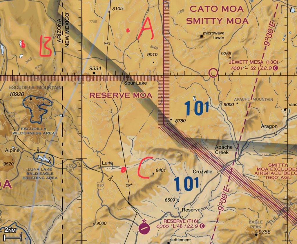
The airport in the lower area is T16 if that helps to locate the area.
luvflyin
Touchdown! Greaser!
I guess I got this confused with a public unpaved airstrip. What would be to radius of that kind of airstrip?
There is no particular number. It’s whatever the airspace around it is. Class G airspace could extend for a hundred miles. Or it could end a mile away if it’s close to a Surface Area. There are some private airports that are in Surface Areas. There are some that have their own Surface Areas.