You are using an out of date browser. It may not display this or other websites correctly.
You should upgrade or use an alternative browser.
You should upgrade or use an alternative browser.
What is this weird cutout in the PDX class "C"
- Thread starter kgruber
- Start date

schmookeeg
En-Route
Looks like Swan island. Probably a 'visual' shelf to assist the little sightseeing choppers.
Considering all of the talking over-educated under-experienced phalluses I live near here, it stands to reason that the PDX Class C would have a dong.
Considering all of the talking over-educated under-experienced phalluses I live near here, it stands to reason that the PDX Class C would have a dong.
midwestpa24
En-Route
- Joined
- Mar 4, 2016
- Messages
- 4,984
- Display Name
Display name:
midwestpa24
Looking at Google Maps, I see some significant sized ships berthed in that area. Ships that could have helicopters land? I don't immediately spot any helipads though. Nor could I figure out why they wouldn't just square it up rather than leave a sliver of Class C to the surface over than small peninsula. To me its like either make it all Class C, or not at all.
Skip Miller
Final Approach
While we are in Portland, notice the word Speedway just to the north of that spot on the map. According to Google Maps, there is a historic speedway there. To the north of that, there is a magenta diamond shape. WTF is the Magenta diamond? -Skip
Timbeck2
Final Approach
Magenta diamond is a stadium
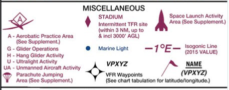
From the Chart User’s guide:While we are in Portland, notice the word Speedway just to the north of that spot on the map. According to Google Maps, there is a historic speedway there. To the north of that, there is a magenta diamond shape. WTF is the Magenta diamond? -Skip
Pilawt
Final Approach
- Joined
- Sep 19, 2005
- Messages
- 9,478
- Display Name
Display name:
Pilawt
They apparently wanted the land area of Swan Island in the Charlie surface area. My guess is for helicopter traffic serving the industrial areas.
BTW, until 1940, Swan Island was Portland's primary airport.


Portland International Raceway, where events are held that qualify for the sports TFR.
BTW, until 1940, Swan Island was Portland's primary airport.
While we are in Portland, notice the word Speedway just to the north of that spot on the map. According to Google Maps, there is a historic speedway there. To the north of that, there is a magenta diamond shape. WTF is the Magenta diamond? -Skip
Portland International Raceway, where events are held that qualify for the sports TFR.
midwestpa24
En-Route
- Joined
- Mar 4, 2016
- Messages
- 4,984
- Display Name
Display name:
midwestpa24
They apparently wanted the land area of Swan Island in the Charlie surface area. My guess is for helicopter traffic serving the industrial areas.
That I can understand, but why the cutout for the waterway?
Pilawt
Final Approach
- Joined
- Sep 19, 2005
- Messages
- 9,478
- Display Name
Display name:
Pilawt
Maybe for the occasional seaplane in the channel?That I can understand, but why the cutout for the waterway?
Perhaps the official description of the Class C surface area says something like "five-mile radius arc from the center of PDX, clockwise to the east bank of the Willamette River, then following the shoreline of the Willamette River to a point x degrees from thus-and-so, then five-mile radius arc ... "
At no point does the Charlie surface area extend into the Willamette River, even though parts of it are less than 5 nm from the airport. I've scooted along the west bank of the river many times, outside the Charlie.
Last edited:
midwestpa24
En-Route
- Joined
- Mar 4, 2016
- Messages
- 4,984
- Display Name
Display name:
midwestpa24
Maybe for the occasional seaplane in the channel?
Perhaps the official description of the Class C surface area says something like "five-mile radius arc from the center of PDX, clockwise to the east bank of the Willamette River, then following the shoreline of the Willamette River to a point x degrees from thus-and-so, then five-mile radius arc ... "
At no point does the Charlie surface area extend into the Willamette River, even though parts of it are less than 5 nm from the airport. I've scooted along the west bank of the river many times, outside the Charlie.
I can buy that. I wasn't considering the prevalence of sea planes in the PNW. So they may have just avoided classifying the water all together. Just don't over fly the peninsula.
If the Class C was to the surface of the water, would a seaplane need authorization to taxi?
RussR
En-Route
In case anybody is interested, here is the official description from the 7400.11D:
That airspace extending upward from the surface to and including 4,000 feet MSL within a 5-mile radius of Portland International Airport, excluding that airspace within a 1-mile radius of Evergreen North-South Airpark and that airspace from the 003° bearing from Evergreen North-South Airpark clockwise to the 105° bearing from Evergreen North-South Airpark, and excluding that airspace up to but not including 1,100 feet MSL in an area bounded by a line beginning at the point where the 019° bearing from Pearson Field intersects the 5-mile arc from Portland International Airport extending southeast to a point 1\1/2\ miles east of Pearson Field on the extended centerline of Runway 8/26 and thence south to the north shore of the Columbia River and thence west via the north shore of the Columbia River to the 5-mile arc from Portland International; and excluding that airspace west of the east bank of the Willamette River; and that airspace extending upward from 2,000 feet MSL to and including 4,000 feet MSL within a 10-mile radius of Portland International Airport from the 004° bearing from the airport clockwise to the 093° bearing from the airport, and that airspace extending upward from 1,700 feet MSL to and including 4,000 feet MSL within a 10- mile radius of the airport from the 093° bearing from the airport clockwise to the 196° bearing from the airport, and that airspace extending upward from 2,300 feet MSL to and including 4,000 feet MSL from the 196° bearing from the airport clockwise to the 268° bearing from the airport, and that airspace extending upward from 1,800 feet MSL to and including 4,000 feet MSL within a 10-mile radius of the airport from the 268° bearing from the airport clockwise to the 004° bearing from the airport.
That airspace extending upward from the surface to and including 4,000 feet MSL within a 5-mile radius of Portland International Airport, excluding that airspace within a 1-mile radius of Evergreen North-South Airpark and that airspace from the 003° bearing from Evergreen North-South Airpark clockwise to the 105° bearing from Evergreen North-South Airpark, and excluding that airspace up to but not including 1,100 feet MSL in an area bounded by a line beginning at the point where the 019° bearing from Pearson Field intersects the 5-mile arc from Portland International Airport extending southeast to a point 1\1/2\ miles east of Pearson Field on the extended centerline of Runway 8/26 and thence south to the north shore of the Columbia River and thence west via the north shore of the Columbia River to the 5-mile arc from Portland International; and excluding that airspace west of the east bank of the Willamette River; and that airspace extending upward from 2,000 feet MSL to and including 4,000 feet MSL within a 10-mile radius of Portland International Airport from the 004° bearing from the airport clockwise to the 093° bearing from the airport, and that airspace extending upward from 1,700 feet MSL to and including 4,000 feet MSL within a 10- mile radius of the airport from the 093° bearing from the airport clockwise to the 196° bearing from the airport, and that airspace extending upward from 2,300 feet MSL to and including 4,000 feet MSL from the 196° bearing from the airport clockwise to the 268° bearing from the airport, and that airspace extending upward from 1,800 feet MSL to and including 4,000 feet MSL within a 10-mile radius of the airport from the 268° bearing from the airport clockwise to the 004° bearing from the airport.
NordicDave
En-Route
In case anybody is interested, here is the official description from the 7400.11D:
That airspace extending upward from the surface to and including 4,000 feet MSL within a 5-mile radius of Portland International Airport, excluding that airspace within a 1-mile radius of Evergreen North-South Airpark and that airspace from the 003° bearing from Evergreen North-South Airpark clockwise to the 105° bearing from Evergreen North-South Airpark, and excluding that airspace up to but not including 1,100 feet MSL in an area bounded by a line beginning at the point where the 019° bearing from Pearson Field intersects the 5-mile arc from Portland International Airport extending southeast to a point 1\1/2\ miles east of Pearson Field on the extended centerline of Runway 8/26 and thence south to the north shore of the Columbia River and thence west via the north shore of the Columbia River to the 5-mile arc from Portland International; and excluding that airspace west of the east bank of the Willamette River; and that airspace extending upward from 2,000 feet MSL to and including 4,000 feet MSL within a 10-mile radius of Portland International Airport from the 004° bearing from the airport clockwise to the 093° bearing from the airport, and that airspace extending upward from 1,700 feet MSL to and including 4,000 feet MSL within a 10- mile radius of the airport from the 093° bearing from the airport clockwise to the 196° bearing from the airport, and that airspace extending upward from 2,300 feet MSL to and including 4,000 feet MSL from the 196° bearing from the airport clockwise to the 268° bearing from the airport, and that airspace extending upward from 1,800 feet MSL to and including 4,000 feet MSL within a 10-mile radius of the airport from the 268° bearing from the airport clockwise to the 004° bearing from the airport.
If a DPE needs to make a boat payment, he should trot this out during his next oral exam. :7) Ahum... Mr. student pilot, read the above paragraph and draw out the airspace.
Shawn
En-Route
That airspace extending upward from the surface to and including 4,000 feet MSL within a 5-mile radius of Portland International Airport, excluding that airspace within a 1-mile radius of Evergreen North-South Airpark and that airspace from the 003° bearing from Evergreen North-South Airpark clockwise to the 105° bearing from Evergreen North-South Airpark, and excluding that airspace up to but not including 1,100 feet MSL in an area bounded by a line beginning at the point where the 019° bearing from Pearson Field intersects the 5-mile arc from Portland International Airport extending southeast to a point 1\1/2\ miles east of Pearson Field on the extended centerline of Runway 8/26 and thence south to the north shore of the Columbia River and thence west via the north shore of the Columbia River to the 5-mile arc from Portland International; and excluding that airspace west of the east bank of the Willamette River; and that airspace extending upward from 2,000 feet MSL to and including 4,000 feet MSL within a 10-mile radius of Portland International Airport from the 004° bearing from the airport clockwise to the 093° bearing from the airport, and that airspace extending upward from 1,700 feet MSL to and including 4,000 feet MSL within a 10- mile radius of the airport from the 093° bearing from the airport clockwise to the 196° bearing from the airport, and that airspace extending upward from 2,300 feet MSL to and including 4,000 feet MSL from the 196° bearing from the airport clockwise to the 268° bearing from the airport, and that airspace extending upward from 1,800 feet MSL to and including 4,000 feet MSL within a 10-mile radius of the airport from the 268° bearing from the airport clockwise to the 004° bearing from the airport.
My head hurts...
Brad Z
Final Approach
LOL, I was just about to post this same 1500 page reference, but it looks like you beat me to it by a few hoursIn case anybody is interested, here is the official description from the 7400.11D:
That airspace extending upward from the surface to and including 4,000 feet MSL within a 5-mile radius of Portland International Airport, excluding that airspace within a 1-mile radius of Evergreen North-South Airpark and that airspace from the 003° bearing from Evergreen North-South Airpark clockwise to the 105° bearing from Evergreen North-South Airpark, and excluding that airspace up to but not including 1,100 feet MSL in an area bounded by a line beginning at the point where the 019° bearing from Pearson Field intersects the 5-mile arc from Portland International Airport extending southeast to a point 1\1/2\ miles east of Pearson Field on the extended centerline of Runway 8/26 and thence south to the north shore of the Columbia River and thence west via the north shore of the Columbia River to the 5-mile arc from Portland International; and excluding that airspace west of the east bank of the Willamette River; and that airspace extending upward from 2,000 feet MSL to and including 4,000 feet MSL within a 10-mile radius of Portland International Airport from the 004° bearing from the airport clockwise to the 093° bearing from the airport, and that airspace extending upward from 1,700 feet MSL to and including 4,000 feet MSL within a 10- mile radius of the airport from the 093° bearing from the airport clockwise to the 196° bearing from the airport, and that airspace extending upward from 2,300 feet MSL to and including 4,000 feet MSL from the 196° bearing from the airport clockwise to the 268° bearing from the airport, and that airspace extending upward from 1,800 feet MSL to and including 4,000 feet MSL within a 10-mile radius of the airport from the 268° bearing from the airport clockwise to the 004° bearing from the airport.
")
For what it’s worth, I used to download a copy of 7400.10, special use airspace, to keep on my iPad back in the days before ForeFlight included SUAS details. Oh how we’re spoiled these days...
Have you been to Portland? Based on the percentage of really screwed up people there, weird stuff is expected...
Pilawt
Final Approach
- Joined
- Sep 19, 2005
- Messages
- 9,478
- Display Name
Display name:
Pilawt
Have you been to Portland? Based on the percentage of really screwed up people there, weird stuff is expected...
Nothing more need be said.
The FAA was trying to "put a bird on it."
schmookeeg
En-Route
Looking at Google Maps, I see some significant sized ships berthed in that area. Ships that could have helicopters land? I don't immediately spot any helipads though. Nor could I figure out why they wouldn't just square it up rather than leave a sliver of Class C to the surface over than small peninsula. To me its like either make it all Class C, or not at all.
There's a fairly busy Robinson flightseeing op that takes off from the top level of a parking garage downtown. I lunch in the 30th floor of the big pink building (Portland City Grill) and watch them take off and land while sipping iced tea.
I think the seaplane theory is better than my own, though. Or it's just legacy and "why mess with it" from the mapmakers. The main jam on Swan Island is the UPS distribution center there. Not really national security stuff.
You can see the helipad under the "Old Town/Chinatown MAX Station" label. Google Maps needs a declutter feature
They usually have 2 or 3 R44s there.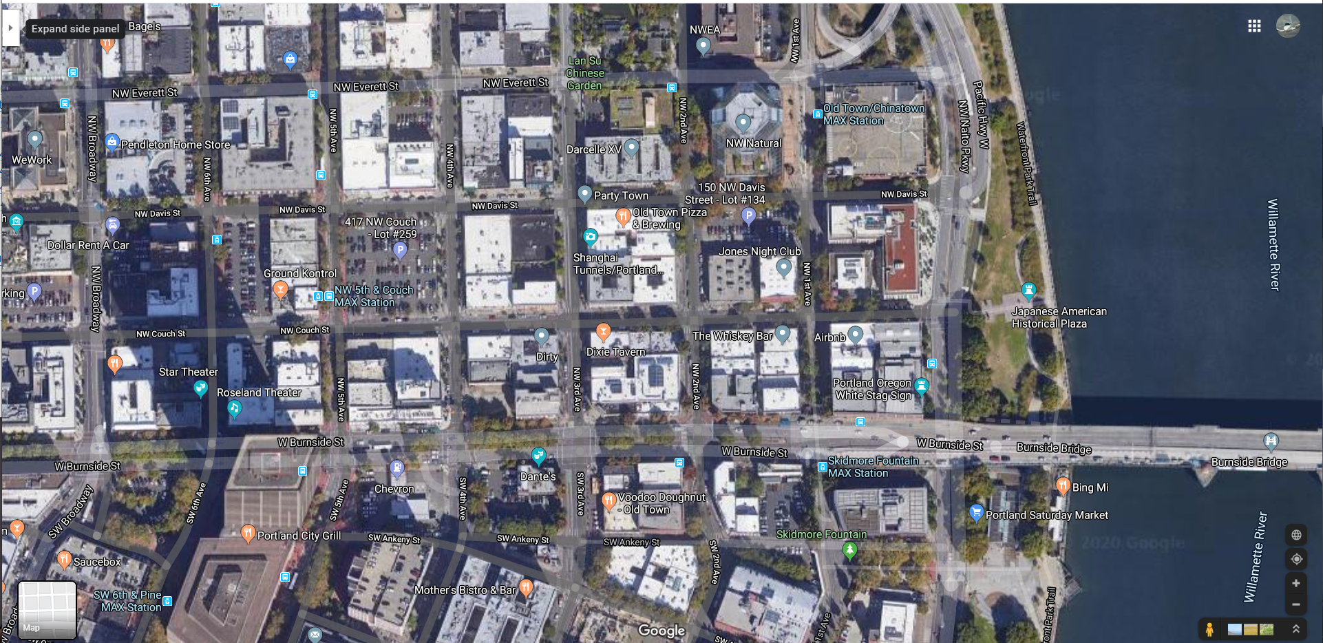
Pilawt
Final Approach
- Joined
- Sep 19, 2005
- Messages
- 9,478
- Display Name
Display name:
Pilawt
I used to live in the slightly-curved 16-story building just to the left of the railroad track and about midway between the two bridges. This pic was about 2011; that neighborhood has a lot more tall condo and apartment buildings now. Swan Island is in the distance on the right. I enjoyed overflying the city over the west bank of the Willamette, 1000' above the tallest building.

luvflyin
Touchdown! Greaser!
Looks like Swan island. Probably a 'visual' shelf to assist the little sightseeing choppers.
Considering all of the talking over-educated under-experienced phalluses I live near here, it stands to reason that the PDX Class C would have a dong.
This is what it’s supposed to look like. I’ll give credit to Lorena Bobbit for doing it right.

Brad Z
Final Approach
“...5-mile arc from Portland International; and excluding that airspace west of the east bank of the Willamette River;”This is what it’s supposed to look like. I’ll give credit to Lorena Bobbit for doing it right.
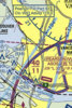
View attachment 82182
It seems to be two different interpretations of “west of the east bank”. The nav data depiction from foreflight you posted above doesn’t seem entirely correct to me either. There is nothing in the legal description to suggest that swan island was to be separated from swan island basin, as depicted on the VFR sectional. In my opinion, swan island basin is not part of the river, and therefore the boundary should follow the swan island Willamette River shoreline until it meets the 5 mile arc.
in reality, itjust doesn’t matter that much.
WillFly4Food
Pre-takeoff checklist
- Joined
- Nov 20, 2016
- Messages
- 207
- Display Name
Display name:
WillFly4Food
Kind of scary trying to peer into the minds of the feds that create this stuff. But interesting nonetheless.
Seems like the intent was to mark the class Charlie boundary in that area as the east bank of the Willamette, and not including the river. Appears that when they encountered to the ship basin, they just continued the same rules: east bank, no river.
For what it’s worth, FlyQ/SeattleAvionics is not trimmed like the graphic above; they have the boundary follow the shoreline, and don’t include the basin.
luvflyin
Touchdown! Greaser!
Of all the sources mentioned here, I think the OP's screenshot of what appears to be the Portland TAC would be the "most correct". All of the 3rd party renditions seem to be a bit suspicious.
It’s an Inset on the Seattle Sectional. I think it’s the same scale as a TAC. Yeah, third party cartographers have their own way of doing it. Based on the description in the 7400.11D I think my ‘fourth’ party rendition is pretty accurate. At any rate, almost all of Swan Island, described as the ‘dong’ in post #5, doesn’t belong in the C Surface area. It’s more than 5 miles from PDX.

luvflyin
Touchdown! Greaser!
LOL, I was just about to post this same 1500 page reference, but it looks like you beat me to it by a few hours
For what it’s worth, I used to download a copy of 7400.10, special use airspace, to keep on my iPad back in the days before ForeFlight included SUAS details. Oh how we’re spoiled these days...
The charting around that area has all kinds of boo boos. Here’s a fun one. What class of airspace is KVUO in. Just look at the Chart. Save the A/FD and the 7400.11 for later.
Brad Z
Final Approach
The charting around that area has all kinds of boo boos. Here’s a fun one. What class of airspace is KVUO in. Just look at the Chart. Save the A/FD and the 7400.11 for later.
The charting around that area has all kinds of boo boos. Here’s a fun one. What class of airspace is KVUO in. Just look at the Chart. Save the A/FD and the 7400.11 for later.
Based on the note regarding part 93 (subpart N) you're pretty much obligated to go off chart to figure out what's going on. But it's class E to the surface (formerly class D) with a communication requirement for communicating with advisory on the CTAF frequency.
Attachments
Pilawt
Final Approach
- Joined
- Sep 19, 2005
- Messages
- 9,478
- Display Name
Display name:
Pilawt
KVUO used to be the only Class D in the country with no operating control tower anywhere in it. A few years ago they changed it from a Class D area to Class E with a Part 93 special flight rule, and tweaked the adjoining Class E surface area boundary a bit. But it didn't change the VFR procedure at KVUO, which requires callup to ATC- on the Pearson CTAF - before entering the area or before departure to get a wake turbulence advisory vis-à-vis PDX jet traffic. After the initial callup it's just like any other uncontrolled field.Based on the note regarding part 93 (subpart N) you're pretty much obligated to go off chart to figure out what's going on. But it's class E to the surface (formerly class D) with a communication requirement for communicating with advisory on the CTAF frequency.
There have been other goofy chart-related things in that region. About ten years ago the sectional came out with Pearson's identifier mis-printed as "VOU". I reported that one to NOS, and a NOTAM was issued forthwith. And around the same time some FAA genius in Renton re-drew the Class D of Salem, greatly enlarging it and adversely affecting VFR operations around Independence (7S5). Cooler heads prevailed, and the SLE Delta was revised to defuse the situation. SLE's Delta is still a weird shape, though, and has a couple of small shelves where the Delta is excluded below 1500' MSL. (Just mind the terrain and obstruction at 1449' MSL just outside that shelf!
)
Last edited:
luvflyin
Touchdown! Greaser!
Based on the note regarding part 93 (subpart N) you're pretty much obligated to go off chart to figure out what's going on. But it's class E to the surface (formerly class D) with a communication requirement for communicating with advisory on the CTAF frequency.
You don’t have to go off Chart to get the Part 93 FAR. It of course does establish the Communication Requirement. But the Chart does depict KVUO in Class G airspace. It is not though. Isn’t going to make any difference to anyone though. Guarding against someone departing VFR Clear of Cloud with 1 mile Visibilty in the day is already covered. Just some fun what does the Chart say stuff.


luvflyin
Touchdown! Greaser!
Nothing more need be said.
That's the Mayor 'campaigning'
Last edited:
Palmpilot
Touchdown! Greaser!
...But the Chart does depict KVUO in Class G airspace....
What about the class E area surface area depicted to the west of VUO? The fact that the magenta dashed line terminates at the class C surface area implies that VUO is inside the class E, since it is not inside the class C surface area. I admit that the depiction is confusing, however.
luvflyin
Touchdown! Greaser!
What about the class E area surface area depicted to the west of VUO? The fact that the magenta dashed line terminates at the class C surface area implies that VUO is inside the class E, since it is not inside the class C surface area. I admit that the depiction is confusing, however.
Yeah. The logic check dictates VUO is in Class E Surface Area. That E Surface Area does not terminate at the edge of the C Surface Area though. It is not an E Surface Area extension to a C Surface Area. That one out to the Northeast is, but not the one to the West. That one IS the VUO Surface Area and it does not stop at the C core Surface Area. It continues farther to the East quite a bit farther than the VUO 'cutout,' but the map makers don't chart it that way.
Pilawt
Final Approach
- Joined
- Sep 19, 2005
- Messages
- 9,478
- Display Name
Display name:
Pilawt
This is a unique situation. Yes, there is only one Class E surface area, but only part of it (the part that used to be the VUO Delta) is the new SFRA. How to chart it? They probably just took the easy route and used the old chart and added the new extension to the west.Yeah. The logic check dictates VUO is in Class E Surface Area. That E Surface Area does not terminate at the edge of the C Surface Area though. It is not an E Surface Area extension to a C Surface Area. That one out to the Northeast is, but not the one to the West. That one IS the VUO Surface Area and it does not stop at the C core Surface Area. It continues farther to the East quite a bit farther than the VUO 'cutout,' but the map makers don't chart it that way.
https://notams.aim.faa.gov/lta/main/viewlta?lookupid=1395914060330964778
"Note: The SFRA replaces the previous Pearson Field Class D airspace with the same dimensions."
luvflyin
Touchdown! Greaser!
This is a unique situation. Yes, there is only one Class E surface area, but only part of it (the part that used to be the VUO Delta) is the new SFRA. How to chart it? They probably just took the easy route and used the old chart and added the new extension to the west.
https://notams.aim.faa.gov/lta/main/viewlta?lookupid=1395914060330964778
"Note: The SFRA replaces the previous Pearson Field Class D airspace with the same dimensions."
Yeah. I’ve thought about how to draw the ‘picture.’ To do it absolutely accurately would look pretty weird. I suppose they could have added a dashed magenta line around the VUO cutout along with solid magenta line that depicts the 1100 foot floor C sector and the feathered blue Part 93 line.