PeterNSteinmetz
Ejection Handle Pulled
I wonder if this basically correlates with whether you learned about maps in 3rd or 4th grade before or after GPS?
")
We already decided north up was the proper way...there was a “checkmate” that should have ended this, pretty sure that’s an Internet rule.
Tom
I wonder if this basically correlates with whether you learned about maps in 3rd or 4th grade before or after GPS?
Why? Do they teach the kids to turn their maps upside down when heading south these days? LOL.
You don't understand, Nate. A "map" isn't a piece of paper anymore, it's an "app."... like a "map" with no "p" and an extra "p"... that tells you where you are, how to get where you're going, and all without any intellectual requirements of any kind on the user. Ain't ejumakashun grate?
It doesn't for me. I learned north up on street maps. When I learned to fly, my primary instructor taught me to turn the sectional track up when I was heading southerly up so things like landmarks were right or left. When I started instrument training I decided I liked north up better for readability, especially approach plates. That carried over to my tablet and it stays north up. My navigator is track up.I wonder if this basically correlates with whether you learned about maps in 3rd or 4th grade before or after GPS?
Common Core map reading skills.Why? Do they teach the kids to turn their maps upside down when heading south these days? LOL.
Yeah, but there was a checkmate after that checkmate for track up.
North up in the plane, track up in the car. Works for me.

it was already decided in the last thread that low wing is the right wing

Two displays, two orientations. Track North on my iFly which shows sectionals and TACs (and my magenta line!), and track up on the EFIS moving map...it shows a lot of towns, roads, etc. that don't show up clearly on the aeronautical charts.
I wonder if this basically correlates with whether you learned about maps in 3rd or 4th grade before or after GPS?
North up in the plane, track up in the car. Works for me.
Me too.
I wish I knew why.
Shrug.
Me too, and I'll tell you why: Because Waze is the best navigation app, hands down, and doesn't really offer north up.
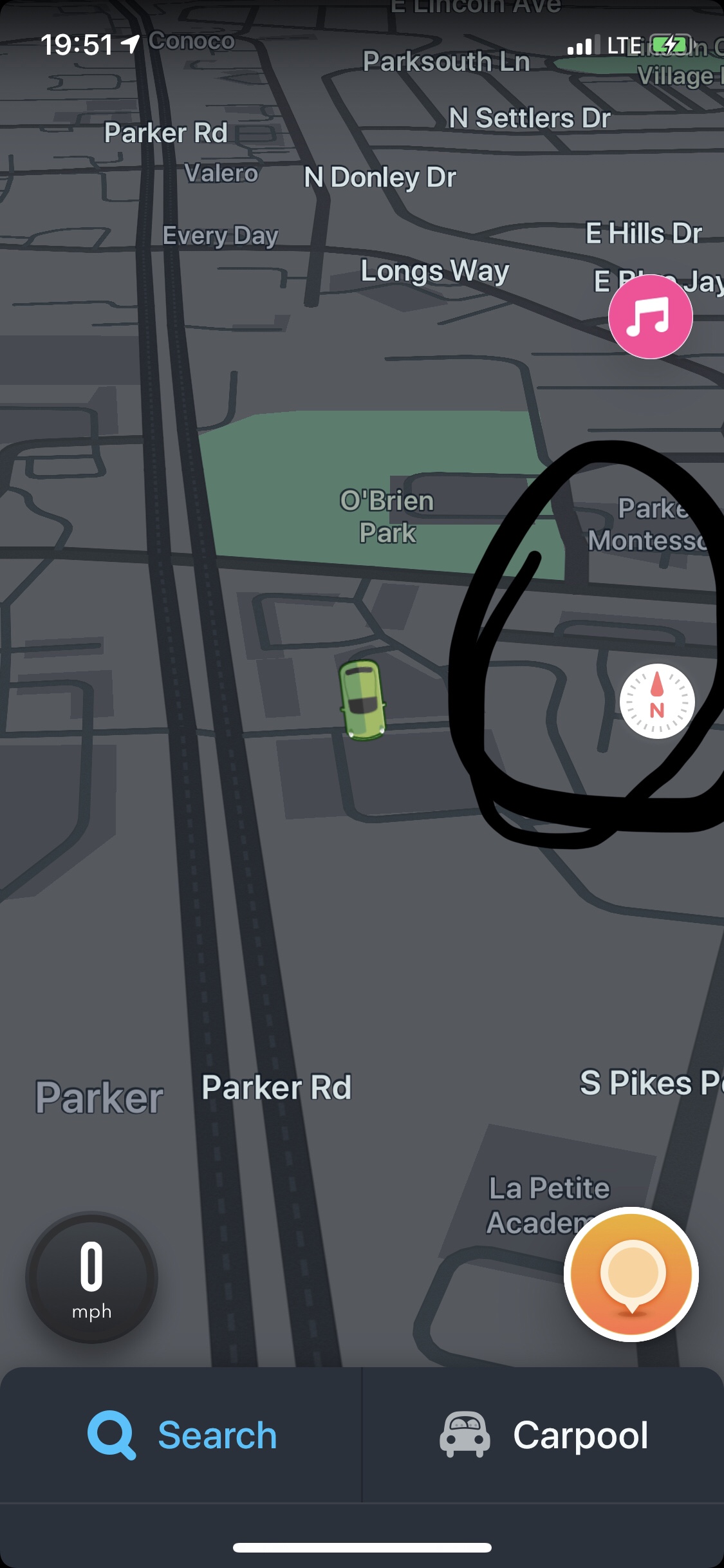
Push the little thing that looks like a compass on the map.
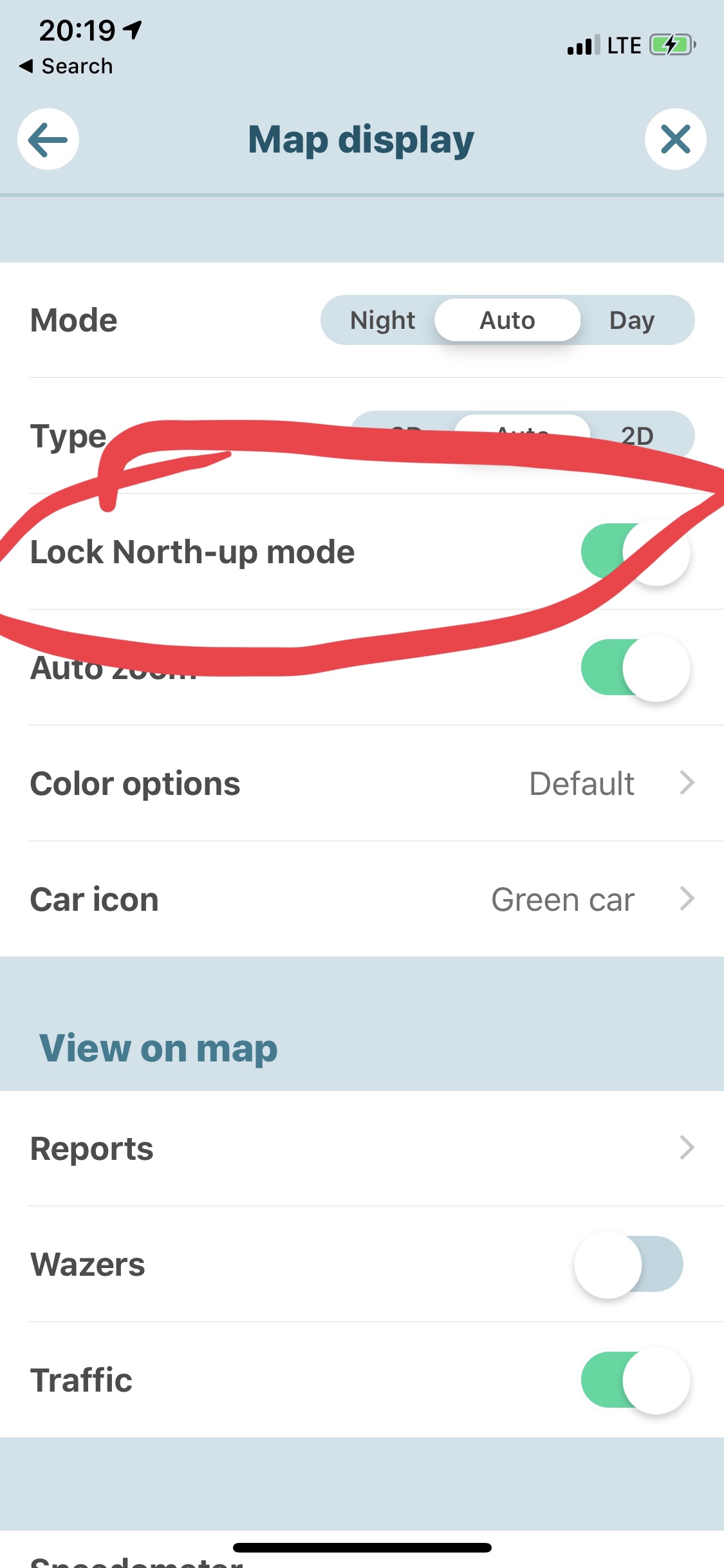
 to access the panel which will show the little settings icon, which then allows a lock north up.
I don’t know what version or platform you’re running Waze on, but on my iPhone you now have to swipe right, with no visual indicator at allto access the panel which will show the little settings icon, which then allows a lock north up.
They use several kinds of swipes now with no visual indication of the need for it. Grrr...
I wonder if this basically correlates with whether you learned about maps in 3rd or 4th grade before or after GPS?
My CFI forced me to to orient the sectional to be track-up. I always flipped it back to north-up whenever he wasn't looking.I doubt it - back in the day “Track Up” folks, myself included, used to turn sectionals to correspond to “Track Up” orientation regardless.
Me too, except I didn't wait until he wasn't looking. It's about the ONLY thing I ever argued with him about, and I told him to feel free to orient the sectional track-up again if I ever made a mistake because it was north-up. That never happened.My CFI forced me to to orient the sectional to be track-up. I always flipped it back to north-up whenever he wasn't looking.
Yellow is better than magenta.

Push the little thing that looks like a compass on the map.
You’re welcome.
Thanks, but... Mine doesn't have that. @PeterNSteinmetz's suggestion did the trick. Awesome!
Discussion arguing about north up and track up using navigators costing tens of thousands and apps we rely on for charts and other critical flight information with a sub-thread showing lack of knowledge of basic functions of a simple, free, car navigation app.You just have to turn it on. I sent screenshots. LOL.
If it’s on AND the north up lock is on, it doesn’t do anything but if force north up isn’t on, it toggles between north and track, which I find more useful than forcing north up on.
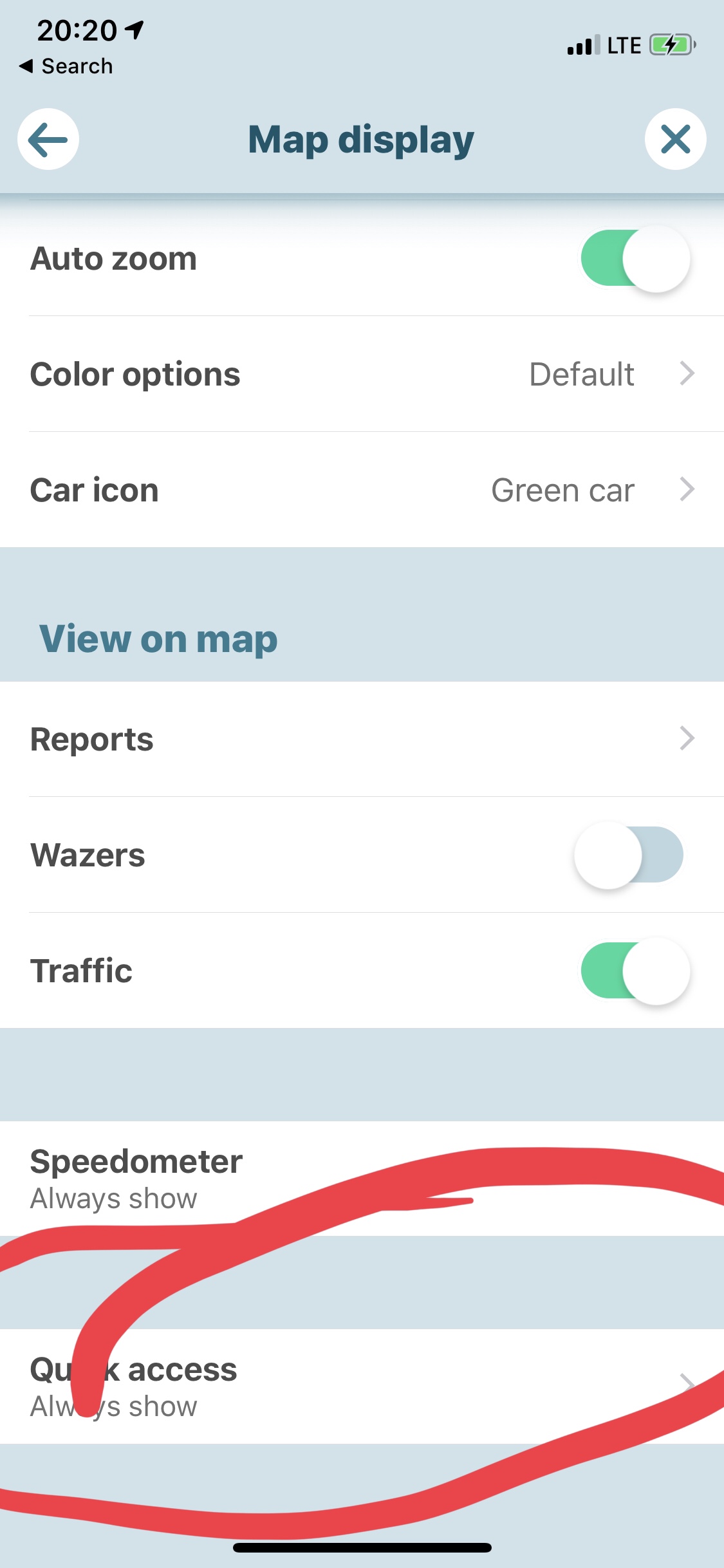
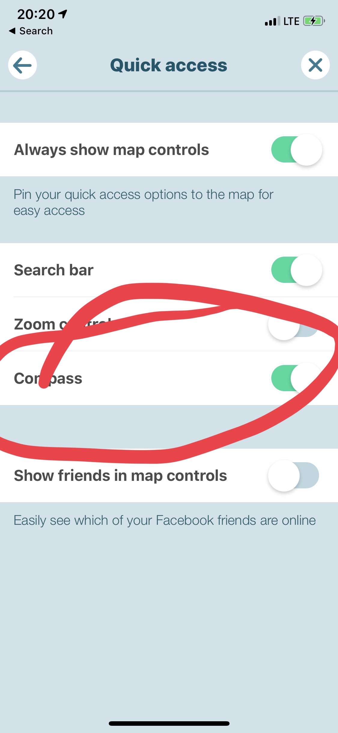
They called it quick access
Discussion arguing about north up and track up using navigators costing tens of thousands and apps we rely on for charts and other critical flight information with a sub-thread showing lack of knowledge of basic functions of a simple, free, car navigation app.
Laugh or cry?
Haha. So a setting that does not really say what it is - some unnamed thing is quick access - is on a second page accessed from a page that is accessed with an unindicated gesture. Really bad UI design. This is why I tend not to use Waze very often anymore.
Pretty much anything else doesn’t have live traffic, so that’s the real value of any of them. I rarely need a map to go anywhere in real time.
My BMW NAV System has a setting for live traffic info. No clue if it uses waze, google, Apple or a mind meld with all German cars in the known universe from HQ in Munich.
But it does have a tendency to act up once in a rare while by changing the setting to nighttime without warning when using track up, according to Dealer Service Department (a clearly impeccable authority). This proves North Up is the correct use of a NAV System. OTOH, as I stated previously, North Up in the Plane, Track Up in the car (with the traffic info off since I couldn’t care less about that).
Cheers
My favorite Waze story is about going to a concert. All of a sudden, Waze goes, "I have a better route. Turn left at [next intersection]. Turns out there was an accident and a tie-up a few miles up. With Waze we lost all of three minutes. Did that - routing us around a sudden traffic tie-up - many times. Crowd-sourced traffic is what makes it worth using. In addition to being smart enough to know the shortcuts.My BMW NAV System has a setting for live traffic info. No clue if it uses waze, google, Apple or a mind meld with all German cars in the known universe from HQ in Munich.
But it does have a tendency to act up once in a rare while by changing the setting to nighttime without warning when using track up, according to Dealer Service Department (a clearly impeccable authority). This proves North Up is the correct use of a NAV System. OTOH, as I stated previously, North Up in the Plane, Track Up in the car (with the traffic info off since I couldn’t care less about that).
Cheers
My favorite Waze story is about going to a concert. All of a sudden, Waze goes, "I have a better route. Turn left at [next intersection]. Turns out there was an accident and a tie-up a few miles up. With Waze we lost all of three minutes. Did that - routing us around a sudden traffic tie-up - many times. Crowd-sourced traffic is what makes it worth using. In addition to being smart enough to know the shortcuts.
The catch is that Waze will offer a change with a very small time differential. At rush hour, things can happen so quickly that once you get there there can be a tie-up where it sends you. We still can't abdicate making decisions.I’ve had similar. Most of the time Waze does a great job.
There’s one “always” traffic jam here on I-70 EVERY rush hour where Waze always sees taking the frontage road for a mile jumping off and back on as one minute faster and it always recommends that. That’s a tad much for me and I just stay on the highway. And Waze is usually wrong in its trickiness depending on how drivers hit the traffic lights on the frontage road.
And then there’s these brilliant folk. Google Maps, not Waze, but hahaha...
https://www.thedenverchannel.com/ne...s-of-colorado-drivers-in-a-mud-mess-on-sunday
I guess I just don’t have much need for live traffic anymore (work mostly from home). I tend to look at Google Maps when I want a map.But I’m curious. What would you recommend? Google Maps is worse. Apple Maps? Laughable.
Unless you live in a neighborhood that takes the brunt of Waze reroutes. Google give the middle finger to the neighborhood, while Wazers tend to give the middle finger to speed limits, stop signs, and no-passing zones (including stopped school buses). Waiting 5+ minutes to get out of your driveway because of the Wazers is not good. And if the municipality tries to stop cut-through so, they get sued.My favorite Waze story is about going to a concert. All of a sudden, Waze goes, "I have a better route. Turn left at [next intersection]. Turns out there was an accident and a tie-up a few miles up. With Waze we lost all of three minutes. Did that - routing us around a sudden traffic tie-up - many times. Crowd-sourced traffic is what makes it worth using. In addition to being smart enough to know the shortcuts.
Must be something about large cities.Unless you live in a neighborhood that takes the brunt of Waze reroutes. Google give the middle finger to the neighborhood, while Wazers tend to give the middle finger to speed limits, stop signs, and no-passing zones (including stopped school buses). Waiting 5+ minutes to get out of your driveway because of the Wazers is not good. And if the municipality tries to stop cut-through so, they get sued.
Google and Waze are the antithesis of corporate social responsibility.